Borówno, Chełmno County: Difference between revisions
Appearance
Content deleted Content added
No edit summary |
Marcin 303 (talk | contribs) No edit summary |
||
| Line 4: | Line 4: | ||
| settlement_type = Village |
| settlement_type = Village |
||
| total_type = |
| total_type = |
||
| image_skyline = Vistula, Borowno, tower.jpg |
|||
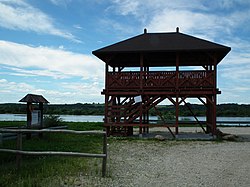
| image_caption = Observation tower near the Vistula River in Borówno |
|||
| image_flag = |
| image_flag = |
||
| image_shield = |
| image_shield = |
||
| Line 15: | Line 17: | ||
| subdivision_type3 = [[Gmina]] |
| subdivision_type3 = [[Gmina]] |
||
| subdivision_name3 = [[Gmina Chełmno]] |
| subdivision_name3 = [[Gmina Chełmno]] |
||
| coordinates = {{coord|53|18|N|18|21|E|region:PL|display=inline}} |
| coordinates = {{coord|53|18|N|18|21|E|region:PL|display=inline,title}} |
||
|pushpin_map=Poland |
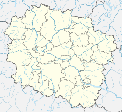
| pushpin_map = Poland#Poland Kuyavian-Pomeranian Voivodeship |
||
| timezone = [[Central European Time|CET]] |
|||
| utc_offset = +1 |
|||
| timezone_DST = [[Central European Summer Time|CEST]] |
|||
| utc_offset_DST = +2 |
|||
| elevation_m = |
| elevation_m = |
||
| population_total = |
| population_total = |
||
| registration_plate = CCH |
|||
| blank_name_sec2 = [[Voivodeship road]]s |
|||
| blank_info_sec2 = [[File:DW248-PL.svg|32px]] [[File:DW550-PL.svg|32px]] |
|||
| website = }} |
| website = }} |
||
'''Borówno''' {{IPAc-pl|b|o|'|r|u|w|n|o}} ({{lang-de|Kulmischborau}}) is a village in the administrative district of [[Gmina Chełmno]], within [[Chełmno County]], [[Kuyavian-Pomeranian Voivodeship]], in north-central Poland.<ref name="TERYT">{{cite web |url=http://www.stat.gov.pl/broker/access/prefile/listPreFiles.jspa |title=Central Statistical Office (GUS) - TERYT (National Register of Territorial Land Apportionment Journal) |date=2008-06-01 |language=Polish}}</ref> It lies approximately {{convert|9|km|mi|0}} south-west of [[Chełmno]], {{convert|31|km|mi|0|abbr=on}} north-east of Bydgoszcz, and {{convert|35|km|mi|0|abbr=on}} north-west of Toruń. |
'''Borówno''' {{IPAc-pl|b|o|'|r|u|w|n|o}} ({{lang-de|Kulmischborau}}) is a village in the administrative district of [[Gmina Chełmno]], within [[Chełmno County]], [[Kuyavian-Pomeranian Voivodeship]], in north-central Poland.<ref name="TERYT">{{cite web |url=http://www.stat.gov.pl/broker/access/prefile/listPreFiles.jspa |title=Central Statistical Office (GUS) - TERYT (National Register of Territorial Land Apportionment Journal) |date=2008-06-01 |language=Polish}}</ref> It lies approximately {{convert|9|km|mi|0}} south-west of [[Chełmno]], {{convert|31|km|mi|0|abbr=on}} north-east of [[Bydgoszcz]], and {{convert|35|km|mi|0|abbr=on}} north-west of [[Toruń]]. It is located on the right bank of the [[Vistula]] river, in the [[Chełmno Land]] in the historic region of [[Pomerania]]. |
||
==History== |
|||
During the [[Occupation of Poland (1939–1945)|German occupation]] ([[World War II]]), in 1939, farmers from Borówno were murdered by the German ''[[Selbstschutz]]'' in the massacre of [[Poles]] committed in nearby [[Płutowo]] as part of the ''[[Intelligenzaktion]]''.<ref>{{cite book|last=Wardzyńska|first=Maria|year=2009|title=Był rok 1939. Operacja niemieckiej policji bezpieczeństwa w Polsce. Intelligenzaktion|language=pl|location=Warszawa|publisher=[[Institute of National Remembrance|IPN]]|pages=166}}</ref> |
|||
==References== |
==References== |
||
| Line 28: | Line 41: | ||
{{Gmina Chełmno}} |
{{Gmina Chełmno}} |
||
{{coord|53.3000|N|18.3500|E|region:PL_type:city_source:enwiki-GNS-gminamatcher|display=title}} |
|||
{{DEFAULTSORT:Borowno, Chelmno County}} |
{{DEFAULTSORT:Borowno, Chelmno County}} |
||
Revision as of 10:45, 28 August 2021
Borówno | |
|---|---|
Village | |
 Observation tower near the Vistula River in Borówno | |
| Coordinates: 53°18′N 18°21′E / 53.300°N 18.350°E | |
| Country | |
| Voivodeship | Kuyavian-Pomeranian |
| County | Chełmno |
| Gmina | Gmina Chełmno |
| Time zone | UTC+1 (CET) |
| • Summer (DST) | UTC+2 (CEST) |
| Vehicle registration | CCH |
| Voivodeship roads | |
Borówno [bɔˈruvnɔ] (Template:Lang-de) is a village in the administrative district of Gmina Chełmno, within Chełmno County, Kuyavian-Pomeranian Voivodeship, in north-central Poland.[1] It lies approximately 9 kilometres (6 mi) south-west of Chełmno, 31 km (19 mi) north-east of Bydgoszcz, and 35 km (22 mi) north-west of Toruń. It is located on the right bank of the Vistula river, in the Chełmno Land in the historic region of Pomerania.
History
During the German occupation (World War II), in 1939, farmers from Borówno were murdered by the German Selbstschutz in the massacre of Poles committed in nearby Płutowo as part of the Intelligenzaktion.[2]
References
- ^ "Central Statistical Office (GUS) - TERYT (National Register of Territorial Land Apportionment Journal)" (in Polish). 2008-06-01.
- ^ Wardzyńska, Maria (2009). Był rok 1939. Operacja niemieckiej policji bezpieczeństwa w Polsce. Intelligenzaktion (in Polish). Warszawa: IPN. p. 166.


