Libohovë: Difference between revisions
Rrapi i Libohovës? |
mNo edit summary |
||
| Line 5: | Line 5: | ||
| emblem = Stema e Bashkisë Libohovë.svg |
| emblem = Stema e Bashkisë Libohovë.svg |
||
| skyline = Libohova.jpg |
| skyline = Libohova.jpg |
||
| caption = Main |
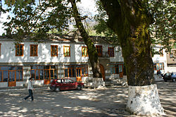
| caption = Main street of Libohovë |
||
| county = Gjirokastër |
| county = Gjirokastër |
||
| mayor = Luiza Mandi |
| mayor = Luiza Mandi |
||
Revision as of 13:40, 5 September 2021
Libohovë | |
|---|---|
 Main street of Libohovë | |
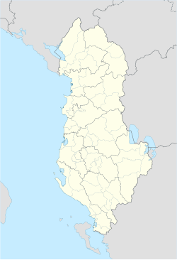
| Coordinates: 40°2′N 20°16′E / 40.033°N 20.267°E | |
| Country | |
| County | Gjirokastër |
| Government | |
| • Mayor | Luiza Mandi (PS) |
| Area | |
| • Municipality | 248.42 km2 (95.92 sq mi) |
| Elevation | 408 m (1,339 ft) |
| Population (2011) | |
| • Municipality | 3,667 |
| • Municipality density | 15/km2 (38/sq mi) |
| • Municipal unit | 1,992 |
| Time zone | UTC+1 (CET) |
| • Summer (DST) | UTC+2 (CEST) |
| Postal Code | 6003 |
| Area Code | (0)881 |
| Website | Official Website |
Libohovë (Albanian definite form: Libohova) is a town and a municipality in southern Albania. It is overlooked by Libohovë Castle and has a main street with views across the Drino valley. Libohovë is at the foot of the Bureto Mountain. The region forms part of the Zagori Regional Nature Park[1] located in Zagori region.
The municipality was formed at the 2015 local government reform by the merger of the former municipalities Libohovë, Qendër Libohovë and Zagori, that became municipal units. The seat of the municipality is the town Libohovë.[2] The total population is 3,667 (2011 census),[3] in a total area of 248.42 km2.[4] The population of the former municipality at the 2011 census was 1,992.[3]
History
The archaeological evidence indicates a very ancient settlement which reached its zenith in the 17th century. It may be the exact site of present Dropull's former Catholic Diocese of Hadrianopolis in Epiro.[5] In the late 17th century, the Ottoman traveler Evliya Çelebi passed through Libohovë noting it was inhabited by Muslim Albanians and had 200 houses, a mosque, prayer house, inn and small bathhouse.[6] Between 1796-1798 the Libohovë Castle was built in the city. In the early 19th century during the rule of Ali Pasha, British diplomat William Martin Leake during his journey from Vlorë to Gjirokastra and later to present-day Greece, in his diary describes his arrival on December 26, 1804, in the region of Derópoli, or Dropull as it was known from the local Albanians. According to him, Libohovë, then part of the same region, numbered about 1000 Muslim families and 100 Christian families.[7]
It is the home of a well-known Albanian noble family, which shares its name with the town. Prior to the communist era they held considerable sway over the country's politics. The castle is a substantial fortress with four polygonal corner towers and a curtain wall surrounding a wide courtyard. The sister of Ali Pasha of Tepelenë, Shanica, married one of the most important members of the Libohovë family and the castle was the dowry that Ali Pasha presented to her.[citation needed] In the town centre was an old plane tree around which a bar-restaurant has been built. Also in the centre is the house of Myfit (Bey) Libohovë (1876–1927), a renowned politician, the first minister of internal affairs and foreign affairs serving in the Albanian Government of 1912.
During the interwar period (20th century) Libohovë was a well watered, large and wealthy settlement located among extensive groves containing 500 houses, its inhabitants spoke Albanian and were mostly Muslim.[8] Libohovë was a centre for the Muslim Sufi Bektashi order with several tekkes located in Dropull.[8]
Places of interest
- Libohovë Castle is the most visited site in city.
- Myfit Bej Libohova's home is located in the centre of the city.
Notable locals
- Myfit Libohova, Albanian government member on nine occasions from 1912 until his death in 1927, holding the positions of Justice Minister, Minister of the Interior, Minister of Finance, and Minister of Foreign Affairs. He was also the founder of the Bank of Albania.
- Abedin Nepravishta, twice former mayor of Tirana, Albania, during 1933-1935 and 1937–1939
- Servet Libohova, mayor of Tiranë
- Eni Çobani, lawyer
- Avni Rustemi, leftist activist of the 1920s.
- Nexhmie Zaimi, Albanian American author and journalist
- Kadri Gjata, Albanian educator
References
- ^ "Archived copy". Archived from the original on December 8, 2015. Retrieved December 3, 2015.
{{cite web}}: CS1 maint: archived copy as title (link) - ^ Law nr. 115/2014 Archived 2015-09-24 at the Wayback Machine
- ^ a b "Population and housing census - Gjirokastër 2011" (PDF). INSTAT. Retrieved 2019-09-25.
- ^ "Correspondence table LAU – NUTS 2016, EU-28 and EFTA / available Candidate Countries" (XLS). Eurostat. Retrieved 2019-09-25.
- ^ http://www.gcatholic.org/dioceses/former/t0063.htm
- ^ Dankoff, Robert; Elsie, Robert (2000). Evliya Çelebi in Albania and Adjacent Regions: Kossovo, Montenegro, Ohrid. Brill. p. 91. ISBN 9789004116245. "We continued westwards from Delvinaki for 6 hours and arrived at the village of Libohova. It is on the border of the kadi-district of Gjirokastër at the foot of a mountain with flowing water, like the fabled garden of Irem. It consists of 200 houses with slate roofs and is inhabited by Albanians, who are, however, Muslims. It has a congregational mosque, a prayer house, a han and a small bathhouse."
- ^ Martin Leake, William (December 1835). Travels in Northern Greece. Vol. 1. New Bond Street, London: Rodwell & Martin. p. 25. ISBN 9781108020114.
- ^ a b Hammond, Nicholas Geoffrey Lemprière (1967). Epirus: the Geography, the Ancient Remains, the History and Topography of Epirus and Adjacent Areas. Oxford: Clarendon Press. p. 29. ISBN 9780198142539. "Libohovë, with some 500 houses, is also a religious centre of the progressive Bektashi sect of Muslims and there were several heroa (teke) with Dervishes in Dhropul during the years between the two World Wars."; p.207 "On the Albanian side the largest and richest village is Libohovë (500 houses), which is situated among the extensive groves and is well watered in contrast to Agyrokastro. The population is almost entirely Mohammedan." p. 209. "Whereas Libohovë and the village north of it are Albanian in speech,"


