Haupt (mountain): Difference between revisions
Appearance
Content deleted Content added
JJMC89 bot (talk | contribs) Migrate {{Infobox mountain}} coordinates parameters to {{Coord}}, see Wikipedia:Coordinates in infoboxes |
#suggestededit-translate 1.0 Tags: Mobile edit Mobile app edit Android app edit |
||
| Line 1: | Line 1: | ||
{{Infobox mountain |
{{Short description|Mountain in switzerland}}{{Infobox mountain |
||
| name = Haupt |
| name = Haupt |
||
| other_name = |
| other_name = |
||
Revision as of 21:51, 12 September 2021
| Haupt | |
|---|---|
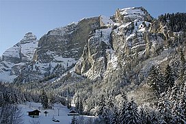
 The Haupt (summit on the left) seen from Stöckalp | |
| Highest point | |
| Elevation | 2,313 m (7,589 ft) |
| Prominence | 145 m (476 ft)[1] |
| Parent peak | Glogghüs |
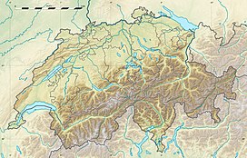
| Coordinates | 46°47′13″N 8°15′10″E / 46.78694°N 8.25278°E |
| Geography | |
| Location | Obwalden, Switzerland |
| Parent range | Urner Alps |
The Haupt is a mountain of the Urner Alps, located between the Klein Melchtal and the Melchtal in the canton of Obwalden. Its east side consists of steep limestone cliffs overlooking Stöckalp and Melchsee-Frutt. On its west side it overlooks the Älggi-Alp.
References
External links

