Arugot: Difference between revisions
Appearance
Content deleted Content added
mNo edit summary |
Don't really see the point of this |
||
| Line 2: | Line 2: | ||
|name = Arugot |
|name = Arugot |
||
|hebname = ערוגות |
|hebname = ערוגות |
||
|arname = عروغوت / عروجوت |
|||
|image = Arugot Aerial View.jpg |
|image = Arugot Aerial View.jpg |
||
|imgsize = 250 |
|imgsize = 250 |
||
Revision as of 17:23, 7 October 2021
Arugot
ערוגות | |
|---|---|
 | |
| Coordinates: 31°44′5″N 34°46′15″E / 31.73472°N 34.77083°E | |
| Country | Israel |
| Council | Be'er Tuvia Regional Council |
| Affiliation | Moshavim Movement |
| Founded | 1949 |
| Founded by | Polish and Romanian Jews |
| Population (2022)[1] | 1,154 |
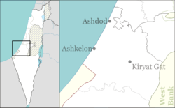
Arugot (Template:Lang-he),[2] is a moshav in central Israel. Located near Kiryat Malakhi, it falls under the jurisdiction of Be'er Tuvia Regional Council. In 2022 its population was 1,154.[1]
History
The moshav was founded in 1949 by Jewish immigrants from Poland and Romania on the land belonging to the depopulated Palestinian village of Qastina.[3] Its name was taken from the Book of Ezekiel 17:7.[4]
References
- ^ a b "Regional Statistics". Israel Central Bureau of Statistics. Retrieved 21 March 2024.
- ^ arugah. Strong's Concordance via biblehub.com. Retrieved 6 Oct 2021.
- ^ Khalidi, Walid (1992). All That Remains: The Palestinian Villages Occupied and Depopulated by Israel in 1948. Washington D.C.: Institute for Palestine Studies. p. 131. ISBN 0-88728-224-5.
- ^ Elʻazari, Yuval, ed. (2005). Mapa's concise gazetteer of Israel (in Hebrew). Tel-Aviv: Mapa Publishing. p. 435. ISBN 965-7184-34-7.

