Mtwapa: Difference between revisions
Appearance
Content deleted Content added
adding |
|||
| Line 25: | Line 25: | ||
== The population of Mtwapa == |
== The population of Mtwapa == |
||
The population growth is shown in the following table.<ref>{{cite web|title=Kenia: Provinzen, Städte, Gemeinden & Urbane Zentren - Einwohnerzahlen in Karten und Tabellen|periodical=|publisher=|url=http://www.citypopulation.de/Kenya-Cities_d.html|url-status=|format=|access-date=|archive-url=|archive-date=|last=|date=|year=|language=|pages=|quote=}}</ref> |
The population growth is shown in the following table.<ref>{{cite web|title=Kenia: Provinzen, Städte, Gemeinden & Urbane Zentren - Einwohnerzahlen in Karten und Tabellen|periodical=|publisher=|url=http://www.citypopulation.de/Kenya-Cities_d.html|url-status=|format=|access-date=|archive-url=|archive-date=|last=|date=|year=|language=|pages=|quote=}}</ref> |
||
{| border="0" cellspacing="0" cellpadding=" |
{| border="0" cellspacing="0" cellpadding="0" |
||
| valign="top" | |
| valign="top" | |
||
{| class="wikitable" |
{| class="wikitable" |
||
Revision as of 10:01, 14 November 2021
Mtwapa | |
|---|---|
| Coordinates: 3°57′00″S 39°44′40″E / 3.95000°S 39.74444°E | |
| Country | Kenya |
| County | Kilifi County |
| Division | Kikambala Division |
| Time zone | UTC+3 (EAT) |


Mtwapa is a town located in Kenya's Kilifi County. It is situated 16 kilometres (10 mi) north of Mombasa on the Mombasa-Malindi road.[1] It is close to the Mombasa Marine National Park and Reserve and Jumba la Mtwana.[2] Two informal settlements in Mtwapa, Majengo and Mzambarauni, are participating in the UN-HABITAT Participatory Slum Upgrading Program.[3] It is run by resident committees and aims to provide every household with drinking water and a toilet.[4][5]
Mtwapa is also a destination for sex tourism, including child sex tourism.[6][7]
The population of Mtwapa
The population growth is shown in the following table.[8]
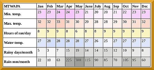
ClimateMtwapa has a tropical wet and dry climate (Köppen: As). The rainiest months are April, May, June and October–November. References
Wikivoyage has a travel guide for Mtwapa. Wikimedia Commons has media related to Mtwapa. |


