Tonashen: Difference between revisions
AntonSamuel (talk | contribs) |
AntonSamuel (talk | contribs) |
||
| Line 40: | Line 40: | ||
== Historical heritage sites == |
== Historical heritage sites == |
||
Historical heritage sites in and around the village include the [[Jraberd]] Fortress ({{lang-hy|Ջրաբերդ}}) from between the 9th and 18th centuries, a medieval church, a 12th/13th-century cemetery, a 13th-century khachkar, the medieval village of ''Mets Tvot'' ({{lang-hy|Մեծ |
Historical heritage sites in and around the village include the [[Jraberd]] Fortress ({{lang-hy|Ջրաբերդ}}) from between the 9th and 18th centuries, a medieval church, a 12th/13th-century cemetery, a 13th-century khachkar, the medieval village of ''Mets Tvot'' ({{lang-hy|Մեծ Թթոտ}}), the 13th-century Kotrats Yeghtsi Church ({{lang-hy|Կոտրած եղցի}}), and the [[Yerits Mankants Monastery]] ({{lang-hy|Երից Մանկանց Վանք}}) built in 1691.<ref name="2015statistics"/> |
||
== Economy and culture == |
== Economy and culture == |
||
Revision as of 13:19, 30 December 2021
Tonashen
Տոնաշեն | |
|---|---|
| Təpəkənd | |
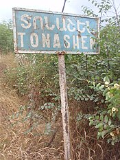
 Village entrance, 2011 | |
| Coordinates: 40°18′10″N 46°41′26″E / 40.30278°N 46.69056°E | |
| Country | |
| District | Tartar (de jure) |
| Province | Martakert (de facto) |
| Population (2015)[1] | |
• Total | 84 |
| Time zone | UTC+4 (AMT) |
Tonashen (Template:Lang-hy; Template:Lang-az) or Tapakend (Template:Lang-az) is a village de facto in the Martakert Province of the self-proclaimed Republic of Artsakh, de jure in the Tartar District of Azerbaijan. The village has an ethnic Armenian-majority population, and also had an Armenian majority in 1989.[2]
History
During the Soviet period, the village was a part of the Mardakert District of the Nagorno-Karabakh Autonomous Oblast.
Historical heritage sites
Historical heritage sites in and around the village include the Jraberd Fortress (Template:Lang-hy) from between the 9th and 18th centuries, a medieval church, a 12th/13th-century cemetery, a 13th-century khachkar, the medieval village of Mets Tvot (Template:Lang-hy), the 13th-century Kotrats Yeghtsi Church (Template:Lang-hy), and the Yerits Mankants Monastery (Template:Lang-hy) built in 1691.[1]
Economy and culture
The population is mainly engaged in agriculture and animal husbandry. As of 2015, the village has a municipal building, a secondary school and a medical centre.[1]
Demographics
The village had 79 inhabitants in 2005,[3] and 84 inhabitants in 2015.[1]
References
- ^ a b c d Hakob Ghahramanyan. "Directory of socio-economic characteristics of NKR administrative-territorial units (2015)".
- ^ Андрей Зубов. "Андрей Зубов. Карабах: Мир и Война". drugoivzgliad.com.
- ^ "The Results of the 2005 Census of the Nagorno-Karabakh Republic" (PDF). National Statistic Service of the Republic of Artsakh.


