Strahovice: Difference between revisions
Appearance
Content deleted Content added
No edit summary |
population, infobox, history, twin towns |
||
| Line 1: | Line 1: | ||
{{Infobox settlement |
{{Infobox settlement |
||
|name=Strahovice |
| name = Strahovice |
||
| native_name = |
|||
| ⚫ | |||
| other_name = |
|||
| ⚫ | |||
| ⚫ | |||
|image_caption= |
|||
<!-- images, nickname, motto --> |
|||
| ⚫ | |||
| ⚫ | |||
| ⚫ | |||
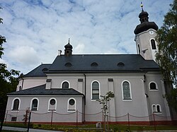
| image_caption = Church of Saint Augustin |
|||
| ⚫ | |||
| ⚫ | |||
|subdivision_name={{CZE}} |
|||
| ⚫ | |||
| ⚫ | |||
| etymology = |
|||
| ⚫ | |||
<!-- location --> |
|||
|subdivision_type2=[[Districts of the Czech Republic|District]] |
|||
| ⚫ | |||
| ⚫ | |||
| |
| subdivision_name = {{CZE}} |
||
| ⚫ | |||
| ⚫ | |||
| ⚫ | |||
| ⚫ | |||
| |
| subdivision_type2 = [[Districts of the Czech Republic|District]] |
||
| ⚫ | |||
| ⚫ | |||
<!-- maps and coordinates --> |
|||
|population_total=886<ref>{{cite web | url=https://www.czso.cz/documents/10180/45964084/13007217.pdf/ | title=Population of Municipalities as of 1 January 2017 | work=Czech Statistical Office | accessdate=26 December 2017}}</ref> |
|||
| image_map = |
|||
| ⚫ | |||
| map_caption = |
|||
| ⚫ | |||
| pushpin_map = Czech Republic |
|||
| ⚫ | |||
| pushpin_relief = 1 |
|||
| ⚫ | |||
| pushpin_map_caption = Location in the Czech Republic |
|||
| ⚫ | |||
| ⚫ | |||
|website= |
|||
| coordinates_footnotes = |
|||
<!-- government type, leaders --> |
|||
| leader_title = Mayor |
|||
| ⚫ | |||
<!-- established --> |
|||
| established_title = First mentioned |
|||
| established_date = 1349 |
|||
<!-- area --> |
|||
| area_footnotes = |
|||
| ⚫ | |||
<!-- elevation --> |
|||
| elevation_footnotes = |
|||
| ⚫ | |||
<!-- population --> |
|||
| ⚫ | |||
| population_footnotes = <ref>{{cite web |title=Population of Municipalities – 1 January 2021|url=https://www.czso.cz/csu/czso/population-of-municipalities-1-january-2021|publisher=[[Czech Statistical Office]]|date=2021-04-30}}</ref> |
|||
| population_total = 885 |
|||
| ⚫ | |||
<!-- time zone(s) --> |
|||
| timezone1 = [[Central European Time|CET]] |
|||
| utc_offset1 = +1 |
|||
| timezone1_DST = [[Central European Summer Time|CEST]] |
|||
| utc_offset1_DST = +2 |
|||
<!-- postal codes, area code --> |
|||
| ⚫ | |||
| ⚫ | |||
| area_code_type = |
|||
| area_code = |
|||
<!-- website, footnotes --> |
|||
| website = {{URL|https://www.strahovice.cz/}} |
|||
| footnotes = |
|||
}} |
}} |
||
'''Strahovice''' ({{lang-de|Strandorf}}) is a village in [[Moravian-Silesian Region]] of the [[Czech Republic]]. It is part of |
'''Strahovice''' ({{lang-de|Strandorf}}) is a municipality and village in [[Opava District]] in the [[Moravian-Silesian Region]] of the [[Czech Republic]]. It has about 900 inhabitants. It is a part of the historic [[Hlučín Region]]. |
||
The first written mention of the village was in 1349. |
|||
==History== |
==History== |
||
The first written mention of Strahovice is from 1349.<ref>{{cite web |title=O obci a okolí|url=https://www.strahovice.cz/obec/o-obci-a-okoli/|publisher=Obec Strahovice|language=cs|access-date=2022-03-08}}</ref> |
|||
Since 1742 the village belonged to Prussia after Maria Theresa had been defeated. |
|||
==Twin towns – sister cities== |
|||
{{See also|List of twin towns and sister cities in the Czech Republic}} |
|||
Strahovice is [[Sister city|twinned]] with:<ref>{{cite web |title=Partnerské obce|url=https://www.strahovice.cz/prakticke-informace/internetove-odkazy/partnerske-obce-1/|website=strahovice.cz|publisher=Obec Strahovice|language=cs|access-date=2022-03-08}}</ref> |
|||
*{{flagicon|POL}} [[Gmina Krzanowice|Krzanowice]], Poland |
|||
*{{flagicon|GER}} [[Ruppach-Goldhausen]], Germany |
|||
==References== |
==References== |
||
| Line 36: | Line 71: | ||
==External links== |
==External links== |
||
| ⚫ | |||
* [http://www.strahovice.cz/ Official website] |
|||
*{{official|https://www.strahovice.cz/}} |
|||
| ⚫ | |||
{{Opava District}} |
{{Opava District}} |
||
{{authority control}} |
{{authority control}} |
||
Revision as of 12:19, 8 March 2022
Strahovice | |
|---|---|
 Church of Saint Augustin | |
| Coordinates: 50°0′7″N 18°5′14″E / 50.00194°N 18.08722°E | |
| Country | |
| Region | Moravian-Silesian |
| District | Opava |
| First mentioned | 1349 |
| Government | |
| • Mayor | Elen Malchárková |
| Area | |
• Total | 5.07 km2 (1.96 sq mi) |
| Elevation | 228 m (748 ft) |
| Population (2021-01-01)[1] | |
• Total | 885 |
| • Density | 170/km2 (450/sq mi) |
| Time zone | UTC+1 (CET) |
| • Summer (DST) | UTC+2 (CEST) |
| Postal code | 747 24 |
| Website | www |
Strahovice (Template:Lang-de) is a municipality and village in Opava District in the Moravian-Silesian Region of the Czech Republic. It has about 900 inhabitants. It is a part of the historic Hlučín Region.
History
The first written mention of Strahovice is from 1349.[2]
Twin towns – sister cities
Strahovice is twinned with:[3]
 Krzanowice, Poland
 Ruppach-Goldhausen, Germany
References
- ^ "Population of Municipalities – 1 January 2021". Czech Statistical Office. 2021-04-30.
- ^ "O obci a okolí" (in Czech). Obec Strahovice. Retrieved 2022-03-08.
- ^ "Partnerské obce". strahovice.cz (in Czech). Obec Strahovice. Retrieved 2022-03-08.
External links
Wikimedia Commons has media related to Strahovice.


