M41 highway: Difference between revisions
YitzhakNat (talk | contribs) |
YitzhakNat (talk | contribs) |
||
| Line 54: | Line 54: | ||
==Galley== |
==Galley== |
||
<gallery widths="280" perrow="5" mode=" |
<gallery widths="280" perrow="5" mode="packed" heights="250"> |
||
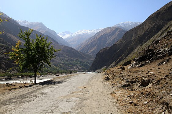
File:Pamir Highway - Tajikistan.jpg|Pamir highway in Tajikistan |
File:Pamir Highway - Tajikistan.jpg|Pamir highway in Tajikistan |
||
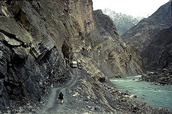
File:Transport-dush-khorog.jpg|The Pamir Highway between Dushanbe and Khorugh |
File:Transport-dush-khorog.jpg|The Pamir Highway between Dushanbe and Khorugh |
||
Revision as of 14:51, 21 April 2022
| M41 highway | |
|---|---|
| Pamir Highway, Pamirsky Trakt, Памирский тракт | |
 The historical Pamir Highway travels through the Central Asian nations of Afghanistan, Uzbekistan, Tajikistan, and Kyrgyzstan. The modern M41 extends further from Osh to Kara-Balta in the western suburbs of Bishkek | |
 Pamir highway from Khargush to Murghab, Tajikistan | |
| Route information | |
| Part of | |
| Length | 1,252 km[1] (778 mi) |
| History | The road formed one link of the ancient Silk Road trade route |
| Location | |
| Countries | |
| Highway system | |
The M41, known informally and more commonly as the Pamir Highway (Russian: "Pamirsky Trakt", Памирский тракт) is a road traversing the Pamir Mountains through Afghanistan, Uzbekistan, Tajikistan, and Kyrgyzstan in Central Asia. It is the only continuous route through the difficult terrain of the mountains and serves as the main supply route to Tajikistan's Gorno-Badakhshan Autonomous Region. The route has been in use for millennia, as there are a limited number of viable routes through the high Pamir Mountains. The road formed one link of the ancient Silk Road trade route. M41 is the Soviet road number, but no road number is generally signposted along the road today, only destinations.
Route description
Sources disagree on the termini of the highway, with Mazari Sharif, Afghanistan; Termiz, Uzbekistan; Dushanbe, Tajikistan; and Khorog, Tajikistan all being offered as the beginning of the highway. All sources, however, agree that the highway ends in Osh, Kyrgyzstan. Today, the route is part of the M41 highway, which starts at Termiz at 37°12′39″N 67°16′20″E / 37.21083°N 67.27222°E and ends at Kara-Balta to the west of Bishkek, Kyrgyzstan at 42°49′40″N 73°52′53″E / 42.82778°N 73.88139°E.[2][3] The route passes northward through Termiz before turning east and crossing into Tajikistan. It then follows a general eastward route through Dushanbe, the capital of Tajikistan, to Khorog, crossing the Kafirnigan, Vakhsh, and Bartang Rivers. From there, it continues east for about 310 kilometers to Murghab, where it crosses the Murghab River. The highway then passes through the 4,655-meter (15,270 ft) high Ak-Baital Pass and past Lake Karakul before crossing into Kyrgyzstan to its terminus in Osh.
The road was constructed partly in the end of 19th century (during The Great Game),[4] and mostly in 1930s by the Soviet Union.[5]
In 2000s Pamir Highway was connected with China and Karakoram Highway.[6]
The Pamir Highway is designated as route M-41 over much of its length in Tajikistan and Kyrgyzstan, and is known as the second highest altitude international highway in the world (4,655 m). The section between Dushanbe and Murghab has the European route number E 008. The section between Sary-Tash and Osh, Kyrgyzstan has the European route number E 007.
Construction and maintenance levels vary substantially along the highway. The roadway is unpaved in some areas, but otherwise paved most of the way.[7] Except for its stretches in Kyrgyzstan and nearing Dushanbe, the road is heavily damaged in most of its length by erosion, earthquakes, landslides, and avalanches.
Sometimes referred to as the "Heroin Highway," much of the ninety tonnes of heroin that are trafficked through Tajikistan each year pass along this route.[8][9]
Popular culture
In the 1985 film Spies Like Us, the decoy GLG-20s played by Chevy Chase and Dan Aykroyd are told to meet their contacts on the "road to Dushanbe," a reference to the M41 highway.
Galley
-
Pamir highway in Tajikistan
-
The Pamir Highway between Dushanbe and Khorugh
-
Pamyr highway near Rushan
-
Pamir highway in Afghanistan
-
Pamir highway along the Afghan border
-
Wakhan river valley
-
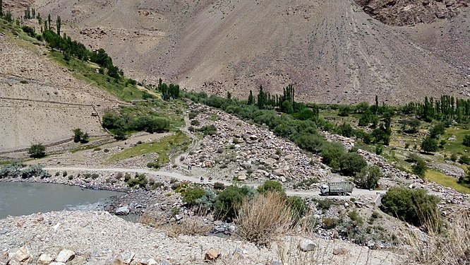
Agricultural landscape near Pamir highway
References
- ^ Noll, Audrey Scott and Daniel. "Driving one of the world's most remote highways". www.bbc.com. Retrieved 2022-04-20.
- ^ Google Maps (Map). Google.
- ^ Bing Maps (Map). Microsoft and Harris Corporation Earthstar Geographics LLC.
- ^ "Pamir Highway History". Retrieved August 15, 2021.
- ^ Salopek, Paul (August 15, 2017). "Sliding off the Roof of the World". National Geographic.
We walk along the Pamir highway—Soviet-built in the 1930s, crumbling back into the elements, and the second highest road in the world after the Karakoram.
- ^ Жизнь у дороги, GEO, Russian Edition, 4 May 2011
- ^ "Pamir Highway Travel Guide". Caravanistan.
- ^ "Road of Sorrow".
- ^ "I Took a Trip Down Tajikistan's 'Heroin Highway'".


