Susanlıq: Difference between revisions
AntonSamuel (talk | contribs) No edit summary |
AntonSamuel (talk | contribs) Expansion, cleanup |
||
| Line 3: | Line 3: | ||
| native_name = Susanlıq / Մոխրենես |
| native_name = Susanlıq / Մոխրենես |
||
| image_skyline = Եկեղեցի Օխտը դռնի։.jpg |
| image_skyline = Եկեղեցի Օխտը դռնի։.jpg |
||
| image_caption = |
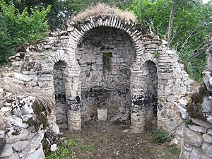
| image_caption = The monastery church of Okhty Drni |
||
| image_size = 300px |
| image_size = 300px |
||
| pushpin_map = Azerbaijan#Republic of Artsakh |
| pushpin_map = Azerbaijan#Republic of Artsakh |
||
| Line 32: | Line 32: | ||
}} |
}} |
||
''' |
'''Susanlyg''' ({{lang-az|Susanlıq}}) or '''Mokhrenes''' ({{lang-hy|Մոխրենես}}) is a village in the [[Khojavend District]] of [[Azerbaijan]], in the [[Political status of Nagorno-Karabakh|disputed]] region of [[Nagorno-Karabakh]]. The village had an ethnic [[Armenians|Armenian]]-majority population prior to the [[2020 Nagorno-Karabakh war]], and also had an Armenian majority in 1989.<ref>{{cite web |url=https://drugoivzgliad.com/karabach-mir-i-voina-a-zubov/ |title=Андрей Зубов. Карабах: Мир и Война |author=Андрей Зубов |date= |website=drugoivzgliad.com |publisher= |access-date= |quote=}}</ref> |
||
== History == |
== History == |
||
During the [[Soviet Union|Soviet]] period, the village was |
During the [[Soviet Union|Soviet]] period, the village was part of the [[Hadrut District (NKAO)|Hadrut District]] of the [[Nagorno-Karabakh Autonomous Oblast]]. After the [[First Nagorno-Karabakh War]], the village was administrated as part of the [[Hadrut Province]] of the breakaway [[Republic of Artsakh]]. The village came under the control of Azerbaijan during the [[2020 Nagorno-Karabakh war]].<ref>{{Cite web |url=https://www.trt.net.tr/azerbaycan/aktual/2020/11/20/az-rbaycanin-isgaldan-azad-edilmis-s-h-r-v-k-ndl-ri-1531478 |title=Azərbaycanın işğaldan azad edilmiş şəhər və kəndləri |trans-title=Liberated cities and villages of Azerbaijan |date=20 November 2020 |access-date=28 January 2021 |work=TRT Azerbaijani |language=az }}</ref> |
||
== Historical heritage sites == |
|||
The village was captured by Armenian forces during the [[First Nagorno-Karabakh War]] and was administrated as part of the [[Hadrut Province]] of the self-proclaimed [[Republic of Artsakh]]. The village was recaptured by Azerbaijan during the [[2020 Nagorno-Karabakh war]].<ref>{{Cite web |url=https://www.trt.net.tr/azerbaycan/aktual/2020/11/20/az-rbaycanin-isgaldan-azad-edilmis-s-h-r-v-k-ndl-ri-1531478 |title=Azərbaycanın işğaldan azad edilmiş şəhər və kəndləri |trans-title=Liberated cities and villages of Azerbaijan |date=20 November 2020 |access-date=28 January 2021 |work=TRT Azerbaijani |language=az }}</ref> |
|||
Historical heritage sites in and around the village include the 5th/6th-century monastery church of ''Okhty Drni'' ({{lang-hy|Օխտը դռնի}}), a 10th/11th-century [[khachkar]], a 13th-century bridge, an 18th/19th-century cemetery, and the church of ''[[Sargis the General|Surb Sargis]]'' ({{lang-hy|Սուրբ Սարգիս}}) built in 1840.<ref name="2015statistics"/> |
|||
== Demographics == |
|||
The village had 212 inhabitants in 2005,<ref name="2005nkrcensus">{{Cite web|url=http://census.stat-nkr.am/nkr/1-1.pdf|title=The Results of the 2005 Census of the Nagorno-Karabakh Republic|website=National Statistic Service of the Republic of Artsakh}}</ref> and 180 inhabitants in 2015.<ref name="2015statistics"/> |
|||
== Gallery == |
|||
<gallery mode="packed" heights="200"> |
|||
Խաչքար Օխտը եղցու տարածքում.jpg|[[Khachkar]] near the monastery church of Okhty Drni with an inscription from 1044<ref>{{cite web|url=https://monumentwatch.org/hy/monument/%D5%B4%D5%B8%D5%AD%D6%80%D5%A5%D5%B6%D5%A5%D5%BD%D5%AB-%D6%85%D5%AD%D5%BF%D5%A8-%D5%A4%D5%BC%D5%B6%D5%AB-%D5%BE%D5%A1%D5%B6%D6%84%D5%A8/|title=Մոխրենեսի «Օխտը դռնի» վանքը|website=monumentwatch.org}}</ref> |
|||
</gallery> |
|||
== References == |
== References == |
||
| Line 50: | Line 59: | ||
{{Portal bar|Geography}} |
{{Portal bar|Geography}} |
||
{{DEFAULTSORT: |
{{DEFAULTSORT:Susanlyg}} |
||
[[Category:Populated places in Khojavend District]] |
[[Category:Populated places in Khojavend District]] |
||
Revision as of 08:48, 20 May 2022
Susanlyg / Mokhrenes
Susanlıq / Մոխրենես | |
|---|---|
 The monastery church of Okhty Drni | |
| Coordinates: Template:Xb_type:city(180) 39°34′10″N 46°55′47″E / 39.56944°N 46.92972°E | |
| Country | |
| District | Khojavend |
| Population (2015)[1] | |
• Total | 180 |
| Time zone | UTC+4 (AZT) |
Susanlyg (Template:Lang-az) or Mokhrenes (Template:Lang-hy) is a village in the Khojavend District of Azerbaijan, in the disputed region of Nagorno-Karabakh. The village had an ethnic Armenian-majority population prior to the 2020 Nagorno-Karabakh war, and also had an Armenian majority in 1989.[2]
History
During the Soviet period, the village was part of the Hadrut District of the Nagorno-Karabakh Autonomous Oblast. After the First Nagorno-Karabakh War, the village was administrated as part of the Hadrut Province of the breakaway Republic of Artsakh. The village came under the control of Azerbaijan during the 2020 Nagorno-Karabakh war.[3]
Historical heritage sites
Historical heritage sites in and around the village include the 5th/6th-century monastery church of Okhty Drni (Template:Lang-hy), a 10th/11th-century khachkar, a 13th-century bridge, an 18th/19th-century cemetery, and the church of Surb Sargis (Template:Lang-hy) built in 1840.[1]
Demographics
The village had 212 inhabitants in 2005,[4] and 180 inhabitants in 2015.[1]
Gallery
References
- ^ a b c Hakob Ghahramanyan. "Directory of socio-economic characteristics of NKR administrative-territorial units (2015)".
- ^ Андрей Зубов. "Андрей Зубов. Карабах: Мир и Война". drugoivzgliad.com.
- ^ "Azərbaycanın işğaldan azad edilmiş şəhər və kəndləri" [Liberated cities and villages of Azerbaijan]. TRT Azerbaijani (in Azerbaijani). 20 November 2020. Retrieved 28 January 2021.
- ^ "The Results of the 2005 Census of the Nagorno-Karabakh Republic" (PDF). National Statistic Service of the Republic of Artsakh.
- ^ "Մոխրենեսի «Օխտը դռնի» վանքը". monumentwatch.org.


![Khachkar near the monastery church of Okhty Drni with an inscription from 1044[5]](/upwiki/wikipedia/commons/thumb/7/71/%D4%BD%D5%A1%D5%B9%D6%84%D5%A1%D6%80_%D5%95%D5%AD%D5%BF%D5%A8_%D5%A5%D5%B2%D6%81%D5%B8%D6%82_%D5%BF%D5%A1%D6%80%D5%A1%D5%AE%D6%84%D5%B8%D6%82%D5%B4.jpg/399px-%D4%BD%D5%A1%D5%B9%D6%84%D5%A1%D6%80_%D5%95%D5%AD%D5%BF%D5%A8_%D5%A5%D5%B2%D6%81%D5%B8%D6%82_%D5%BF%D5%A1%D6%80%D5%A1%D5%AE%D6%84%D5%B8%D6%82%D5%B4.jpg)

