Ambodiriana: Difference between revisions
Appearance
Content deleted Content added
Add hatnote |
img |
||
| Line 9: | Line 9: | ||
|motto = |
|motto = |
||
<!-- images and maps -----------> |
<!-- images and maps -----------> |
||
|image_skyline = |
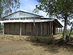
|image_skyline =School Madagascar EPP Ambodiriana.jpg |
||
|imagesize =240px |
|imagesize =240px |
||
|image_caption = |
|image_caption = The school of Ambodiriana |
||
|image_flag = |
|image_flag = |
||
|flag_size = |
|flag_size = |
||
Latest revision as of 01:13, 3 June 2022
Ambodiriana | |
|---|---|
 The school of Ambodiriana | |
| Coordinates: 17°53′10″S 49°11′15″E / 17.88611°S 49.18750°E | |
| Country | |
| Region | Atsinanana |
| District | Toamasina II |
| Area | |
• Total | 226 km2 (87 sq mi) |
| Population (2019)Census | |
• Total | 9,861 |
| Time zone | UTC3 (EAT) |
| Postal code | 501 |
Ambodiriana is a rural commune in the district of Toamasina II (district), in the region of Atsinanana, on the east coast of Madagascar.
Economy
[edit]The economy is based on agriculture. Rice, manioc & corn are grown, other crops are lychee, cloves, cacao, coffee, papaya, banana and sugar cane.[1]
Rivers
[edit]Two rivers cross the municipality: Ivoloina and Ifontsy.
Nature
[edit]- The Betampona Reserve is partly located in this municipality.


