Branišov: Difference between revisions
Appearance
population, infobox, history |
m FromCzech moved page Branišov (České Budějovice District) to Branišov: the only municipality with this name |
(No difference)
| |
Revision as of 05:21, 6 June 2022
Branišov | |
|---|---|
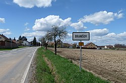
 Entrance to Branišov | |
| Coordinates: 48°58′44″N 14°23′45″E / 48.97889°N 14.39583°E | |
| Country | |
| Region | South Bohemian |
| District | České Budějovice |
| First mentioned | 1391 |
| Area | |
• Total | 5.18 km2 (2.00 sq mi) |
| Elevation | 409 m (1,342 ft) |
| Population (2022-01-01)[1] | |
• Total | 275 |
| • Density | 53/km2 (140/sq mi) |
| Time zone | UTC+1 (CET) |
| • Summer (DST) | UTC+2 (CEST) |
| Postal code | 373 84 |
| Website | branisov |
Branišov is a municipality and village in České Budějovice District in the South Bohemian Region of the Czech Republic. It has about 300 inhabitants.
Branišov lies approximately 6 kilometres (4 mi) west of České Budějovice and 124 km (77 mi) south of Prague.
History
The first written mention of Branišov is from 1391.[2]
References
- ^ "Population of Municipalities – 1 January 2022". Czech Statistical Office. 2022-04-29.
- ^ "Bošilec" (in Czech). Obec Branišov. Retrieved 2022-06-06.
Wikimedia Commons has media related to Branišov.

