Kováň: Difference between revisions
Appearance
Content deleted Content added
population, infobox |
flag |
||
| Line 6: | Line 6: | ||
| image_skyline = Kováň, zástavba (2).jpg |
| image_skyline = Kováň, zástavba (2).jpg |
||
| image_caption = A street in Kováň |
| image_caption = A street in Kováň |
||
| image_flag = |
| image_flag = Kováň Flag.jpg |
||
| image_shield = |
| image_shield = Kováň CoA.jpg |
||
<!-- location --> |
<!-- location --> |
||
| subdivision_type = Country |
| subdivision_type = Country |
||
Revision as of 08:39, 13 June 2022
Kováň | |
|---|---|
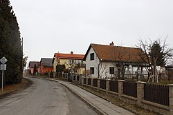
 A street in Kováň | |
| Coordinates: 50°25′24″N 14°46′40″E / 50.42333°N 14.77778°E | |
| Country | |
| Region | Central Bohemian |
| District | Mladá Boleslav |
| First mentioned | 1219 |
| Area | |
• Total | 1.63 km2 (0.63 sq mi) |
| Elevation | 301 m (988 ft) |
| Population (2022-01-01)[1] | |
• Total | 150 |
| • Density | 92/km2 (240/sq mi) |
| Time zone | UTC+1 (CET) |
| • Summer (DST) | UTC+2 (CEST) |
| Postal code | 294 25 |
| Website | www |
Kováň is a municipality and village in Mladá Boleslav District in the Central Bohemian Region of the Czech Republic. It has about 200 inhabitants.
References
Wikimedia Commons has media related to Kováň.


