Karle (Svitavy District): Difference between revisions
Appearance
Content deleted Content added
m Added a word. This article requires more work. |
population, infobox, parts |
||
| Line 1: | Line 1: | ||
{{For|the cave monuments in India|Karla Caves}} |
|||
{{unreferenced|date=March 2016}} |
|||
{{Infobox settlement |
{{Infobox settlement |
||
| name = Karle |
| name = Karle |
||
| native_name = |
|||
| other_name = |
| other_name = |
||
| settlement_type = |
| settlement_type = [[Obec|Municipality]] |
||
<!-- images, nickname, motto --> |
<!-- images, nickname, motto --> |
||
| image_skyline = Karle, municipal office.jpg |
| image_skyline = Karle, municipal office.jpg |
||
| Line 12: | Line 8: | ||
| image_flag = Karle_flag_CZ.svg |
| image_flag = Karle_flag_CZ.svg |
||
| image_shield = Karle_CoA_CZ.svg |
| image_shield = Karle_CoA_CZ.svg |
||
| motto = |
|||
| nickname = |
|||
| etymology = Charles' well (source, spring) |
|||
<!-- location --> |
<!-- location --> |
||
| subdivision_type = Country |
| subdivision_type = Country |
||
| subdivision_name = |
| subdivision_name = {{CZE}} |
||
| subdivision_type1 = |
| subdivision_type1 = [[Regions of the Czech Republic|Region]] |
||
| subdivision_name1 = |
| subdivision_name1 = [[Pardubice Region|Pardubice]] |
||
| subdivision_type2 = [[ |
| subdivision_type2 = [[Districts of the Czech Republic|District]] |
||
| subdivision_name2 = [[ |
| subdivision_name2 = [[Svitavy District|Svitavy]] |
||
| subdivision_type3 = [[Districts of the Czech Republic|District]] |
|||
| subdivision_name3 = [[Svitavy District|Svitavy]] |
|||
| subdivision_type4 = |
|||
| subdivision_name4 = |
|||
<!-- maps and coordinates --> |
<!-- maps and coordinates --> |
||
| image_map = |
| image_map = |
||
| map_caption = |
| map_caption = |
||
| pushpin_map = |
| pushpin_map = Czech Republic |
||
| pushpin_relief = 1 |
| pushpin_relief = 1 |
||
| pushpin_map_caption = Location in the Czech Republic |
| pushpin_map_caption = Location in the Czech Republic |
||
| coordinates = {{coord|49| |
| coordinates = {{coord|49|45|58|N|16|21|53|E|display=inline,title}} |
||
| coordinates_footnotes = |
| coordinates_footnotes = |
||
<!-- government type, leaders --> |
<!-- government type, leaders --> |
||
| leader_title = |
| leader_title = |
||
| leader_name = |
| leader_name = |
||
<!-- established --> |
<!-- established --> |
||
| established_title = First mentioned |
| established_title = First mentioned |
||
| Line 42: | Line 31: | ||
<!-- area --> |
<!-- area --> |
||
| area_footnotes = |
| area_footnotes = |
||
| area_total_km2 = 19. |
| area_total_km2 = 19.03 |
||
| area_total_sq_mi = |
|||
| area_land_sq_mi = |
|||
| area_water_sq_mi = |
|||
<!-- elevation --> |
<!-- elevation --> |
||
| elevation_footnotes = |
| elevation_footnotes = |
||
| elevation_m = 492 |
| elevation_m = 492 |
||
| elevation_ft = |
|||
<!-- population --> |
<!-- population --> |
||
| population_as_of = |
| population_as_of = 2022-01-01 |
||
| population_footnotes = <ref>{{cite web |title=Population of Municipalities – 1 January 2022|url=https://www.czso.cz/csu/czso/population-of-municipalities-1-january-2022|publisher=[[Czech Statistical Office]]|date=2022-04-29}}</ref> |
|||
| population_footnotes = |
|||
| population_total = |
| population_total = 409 |
||
| population_density_km2 = auto |
| population_density_km2 = auto |
||
| population_density_sq_mi= |
|||
| population_demonym = |
|||
<!-- time zone(s) --> |
<!-- time zone(s) --> |
||
| timezone1 = [[Central European Time|CET]] |
| timezone1 = [[Central European Time|CET]] |
||
| Line 65: | Line 48: | ||
| postal_code_type = Postal code |
| postal_code_type = Postal code |
||
| postal_code = 568 02 |
| postal_code = 568 02 |
||
| area_code_type = |
| area_code_type = |
||
| area_code = |
| area_code = |
||
| geocode = |
|||
| iso_code = |
|||
<!-- website, footnotes --> |
<!-- website, footnotes --> |
||
| website = |
| website = {{URL|http://www.svitavskoweb.cz/index.php?obec=karle}} |
||
| footnotes = |
| footnotes = |
||
}} |
}} |
||
'''Karle''' ({{IPA-cs|ˈkarlɛ}}; {{lang-de|Karlsbrunn}}) is a municipality and village in [[Svitavy District]] in the [[Pardubice Region]] of the [[Czech Republic]]. It has about 400 inhabitants. |
|||
==Administrative parts== |
|||
'''Karle''' ({{IPA-cs|ˈkarlɛ}}, {{lang-de|Karlsbrunn}}) is a village and municipality in [[Pardubice Region]] of the [[Czech Republic]] located about 8 km west of [[Svitavy]]. It has a population of 395 (2007). [https://web.archive.org/web/20110523215845/http://vdb.czso.cz/vdbvo/tabdetail.jsp?cislotab=MOS+ZV01&kapitola_id=5&kontext=t&razeni=ta&pro_3260478=572748] |
|||
The village of Ostrý Kámen is an administrative part of Karle. |
|||
==References== |
|||
The first written mention of the village (''Karelsprun'') dates back to 1336. |
|||
{{reflist}} |
|||
| ⚫ | |||
==External links== |
|||
| ⚫ | |||
{{Svitavy District}} |
{{Svitavy District}} |
||
{{authority control}} |
{{authority control}} |
||
{{DEFAULTSORT:Karle}} |
|||
[[Category:Villages in Svitavy District]] |
[[Category:Villages in Svitavy District]] |
||
Revision as of 09:57, 26 July 2022
Karle | |
|---|---|
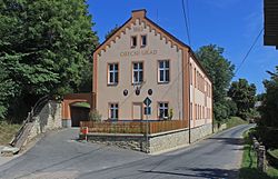
 Municipal office | |
| Coordinates: 49°45′58″N 16°21′53″E / 49.76611°N 16.36472°E | |
| Country | |
| Region | Pardubice |
| District | Svitavy |
| First mentioned | 1336 |
| Area | |
• Total | 19.03 km2 (7.35 sq mi) |
| Elevation | 492 m (1,614 ft) |
| Population (2022-01-01)[1] | |
• Total | 409 |
| • Density | 21/km2 (56/sq mi) |
| Time zone | UTC+1 (CET) |
| • Summer (DST) | UTC+2 (CEST) |
| Postal code | 568 02 |
| Website | www |
Karle (Czech pronunciation: [ˈkarlɛ]; Template:Lang-de) is a municipality and village in Svitavy District in the Pardubice Region of the Czech Republic. It has about 400 inhabitants.
Administrative parts
The village of Ostrý Kámen is an administrative part of Karle.
References
Wikimedia Commons has media related to Karle.


