Espelkamp: Difference between revisions
Appearance
Content deleted Content added
add pic from Commons #WPWP Tag: Contest or editathon |
|||
| Line 1: | Line 1: | ||
{{Infobox German |
{{Infobox German place |
||
|name = Espelkamp |
|name = Espelkamp |
||
|type |
|type = Stadt |
||
|image_photo = |
|image_photo = Espelkamp Breslauer Straße Brunnen.jpg |
||
|imagesize = <!-- Photo size. Default is 250px --> |
|imagesize = <!-- Photo size. Default is 250px --> |
||
|image_caption = <!-- Caption --> |
|image_caption = <!-- Caption --> |
||
| Line 44: | Line 44: | ||
|} |
|} |
||
=== |
=== Town subdivisions === |
||
After the local government reforms of 1973 Espelkamp consists of 9 districts: |
After the local government reforms of 1973 Espelkamp consists of 9 districts: |
||
{| class="wikitable" |
{| class="wikitable" |
||
| Line 84: | Line 84: | ||
==External links== |
==External links== |
||
{{Commons category}} |
|||
* [http://www.espelkamp.de/ Official site] {{in lang|de}} |
* [http://www.espelkamp.de/ Official site] {{in lang|de}} |
||
{{Cities and towns in Minden-Lübbecke (district)}} |
{{Cities and towns in Minden-Lübbecke (district)}} |
||
{{Authority control}} |
{{Authority control}} |
||
Revision as of 15:53, 9 August 2022
Espelkamp | |
|---|---|
 | |
Location of Espelkamp within Minden-Lübbecke district  | |
| Coordinates: 52°22′38″N 8°37′58″E / 52.37722°N 8.63278°E | |
| Country | Germany |
| State | North Rhine-Westphalia |
| Admin. region | Detmold |
| District | Minden-Lübbecke |
| Subdivisions | 9 districts |
| Government | |
| • Mayor (2020–25) | Henning Vieker[1] (CDU) |
| • Governing parties | CDU |
| Area | |
• Total | 84.1 km2 (32.5 sq mi) |
| Elevation | 50 m (160 ft) |
| Population (2023-12-31)[2] | |
• Total | 25,294 |
| • Density | 300/km2 (780/sq mi) |
| Time zone | UTC+01:00 (CET) |
| • Summer (DST) | UTC+02:00 (CEST) |
| Postal codes | 32339 |
| Dialling codes | 05772 |
| Vehicle registration | MI |
| Website | www.espelkamp.de |
Espelkamp is a town in the Minden-Lübbecke district, in North Rhine-Westphalia, Germany.
Geography
Espelkamp is situated approximately 10 kilometers north of Lübbecke and 20 kilometers north-west of Minden.
Neighbouring places
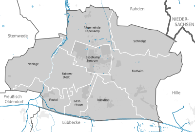
Town subdivisions
After the local government reforms of 1973 Espelkamp consists of 9 districts:
| village | population 31. Dez. 2007[3] |
Stadtgliederung  |
|---|---|---|
| Altgemeinde Espelkamp | 965 | |
| Fabbenstedt | 829 | |
| Fiestel | 1.023 | |
| Frotheim | 2.674 | |
| Gestringen | 1.834 | |
| Isenstedt | 2.658 | |
| Schmalge | 399 | |
| Vehlage | 618 | |
| Espelkamp Zentrum¹ | 15.553 | |
Twin towns – sister cities
 Angermünde, Germany
 Borås, Sweden
 Nagykőrös, Hungary
 Torgelow, Germany
References
- ^ Wahlergebnisse in NRW Kommunalwahlen 2020, Land Nordrhein-Westfalen, accessed 21 June 2021.
- ^ "Bevölkerung der Gemeinden Nordrhein-Westfalens am 31. Dezember 2023 – Fortschreibung des Bevölkerungsstandes auf Basis des Zensus vom 9. Mai 2011" (in German). Landesbetrieb Information und Technik NRW. Retrieved 2024-06-20.
- ^ Espelkamp: Stadtportrait, Statistik
- ^ "Partnerstädte" (in German). Espelkamp. Retrieved 2021-12-09.
External links
Wikimedia Commons has media related to Espelkamp.
- Official site (in German)


