Aviapolis: Difference between revisions
correct subdivisions |
Pic update |
||
| Line 41: | Line 41: | ||
==Retail== |
==Retail== |
||
[[Image:Kauppakeskus |
[[Image:Kauppakeskus Jumbon keskusaukio.jpg|thumb|right|[[Jumbo shopping centre]]]] |
||
Central Aviapolis holds [[Jumbo Shopping Centre]], which is Finland's fourth largest shopping center, with an adjacent entertainment center [[Flamingo, Finland|Flamingo]] that began operating in 2008. |
Central Aviapolis holds [[Jumbo Shopping Centre]], which is Finland's fourth largest shopping center, with an adjacent entertainment center [[Flamingo, Finland|Flamingo]] that began operating in 2008. |
||
Revision as of 16:11, 23 August 2022
Aviapolis | |
|---|---|
Major Region of Vantaa | |
 Apartment buildings along the Pehtoorintie street in Pakkala, Aviapolis, Vantaa | |
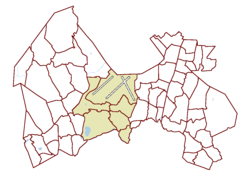
 The Aviapolis major region in Vantaa | |
| Coordinates: 60°18′N 24°57′E / 60.300°N 24.950°E | |
| Country | |
| City | |
| Area | |
• Total | 38.0 km2 (14.7 sq mi) |
| Population (1 January 2014)[1] | |
• Total | 18,327 |
| • Density | 480/km2 (1,200/sq mi) |
| Time zone | GMT +2 |
| Postal Code(s) | 01510, 01520, 01530, 01690, 01740 |
| Website | www |
Aviapolis is a business, retail, entertainment, and housing marketing brand area in central Vantaa, Finland, covering roughly 40 square kilometres (15 sq mi), including Finland's main airline hub and airport, Helsinki Airport.
The term is officially used as the name of one of the major regions of Vantaa, encompassing the districts of Lentokenttä, Pakkala, Tammisto, Veromies, Viinikkala, and Ylästö. It is Vantaa's only major region not named after a city district.
Business
Currently Aviapolis is referred to as the most popular business site in Greater Helsinki, surpassing even the Helsinki City center.[2] Businesses areas already located at Aviapolis include Technopolis Technology Park, Airport Plaza Business Park Oy, and the WTC Helsinki Airport.
Transport

Having Finland's largest airport, Helsinki Airport, the international connections of Aviapolis are broad, boasting the shortest flying distances from EU to many Asian destinations.[3]
The Ring III beltway going through the Aviapolis area connects it with all main highways in and out of the Helsinki Metropolitan Area. Several bus lines connect the airport both to many Finnish cities as well as to many suburbs in Helsinki, Espoo, and Vantaa.
Aviapolis and the airport are linked by the Ring Rail Line to the main railway line, downtown Helsinki, and suburbs of western and eastern Vantaa. The line opened in July 2015, with two stations in the area: Aviapolis railway station and Airport railway station.
Public transportation in and out of the area is also done through Helsinki Regional Transport Authority bus connections.
Retail

Central Aviapolis holds Jumbo Shopping Centre, which is Finland's fourth largest shopping center, with an adjacent entertainment center Flamingo that began operating in 2008.
Housing

The Aviapolis area includes, among others, the Kartanonkoski housing district, located in Pakkala, which houses the International School of Vantaa. The Helsinki Central Park is situated south of the district, in the neighboring capital city.
See also
References
- ^ Vantaan väestö 2013/2014 (PDF) (Report). Vantaa: City of Vantaa, Tietopalveluyksikkö. 20 August 2014. p. 33. ISBN 978-952-443-480-5. Archived from the original (PDF) on 2 February 2015. Retrieved 1 May 2015.
- ^ Helsingin Sanomat International Edition Aviapolis trade centre to accommodate major trade fair facilities, 17 March 2008
- ^ City of Vantaa Your journey starts at Helsinki-Vantaa, 10 July 2007
External links
- https://web.archive.org/web/20080324115401/http://www.aviapolis.fi/en.php Aviapolis Official Web Site
- http://www.fgo.fi/ Flamingo entertainment centre & Spa
- http://www.jumbo.fi/ Jumbo Shopping Centre

