Přepychy (Pardubice District): Difference between revisions
Appearance
Content deleted Content added
population, infobox |
symbols |
||
| Line 6: | Line 6: | ||
| image_skyline = Přepychy křížek a zvonička.JPG |
| image_skyline = Přepychy křížek a zvonička.JPG |
||
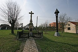
| image_caption = Cross and belfry in the centre of Přepychy |
| image_caption = Cross and belfry in the centre of Přepychy |
||
| image_flag = |
| image_flag = Přepychy Flag.jpg |
||
| image_shield = |
| image_shield = Přepychy CoA.jpg |
||
<!-- location --> |
<!-- location --> |
||
| subdivision_type = Country |
| subdivision_type = Country |
||
Revision as of 11:27, 23 September 2022
Přepychy | |
|---|---|
 Cross and belfry in the centre of Přepychy | |
| Coordinates: 50°6′23″N 15°31′12″E / 50.10639°N 15.52000°E | |
| Country | |
| Region | Pardubice |
| District | Pardubice |
| First mentioned | 1337 |
| Area | |
• Total | 2.55 km2 (0.98 sq mi) |
| Elevation | 225 m (738 ft) |
| Population (2022-01-01)[1] | |
• Total | 82 |
| • Density | 32/km2 (83/sq mi) |
| Time zone | UTC+1 (CET) |
| • Summer (DST) | UTC+2 (CEST) |
| Postal code | 533 16 |
| Website | www |
Přepychy is a municipality and village in Pardubice District in the Pardubice Region of the Czech Republic. It has about 80 inhabitants.
References
External links
Wikimedia Commons has media related to Přepychy (Pardubice District).


