Byadagi: Difference between revisions
Image added Tags: Mobile edit Mobile web edit Advanced mobile edit |
m →top: Fixed grammar, fixed links, fixed typo Tags: Mobile edit Mobile app edit Android app edit |
||
| Line 3: | Line 3: | ||
{{EngvarB|date=March 2014}} |
{{EngvarB|date=March 2014}} |
||
{{Infobox settlement |
{{Infobox settlement |
||
|official_name = |
|official_name = Byadagi |
||
|image_skyline =Byadagi Menasinakaayi.jpg |
|image_skyline =Byadagi Menasinakaayi.jpg |
||
|caption = |
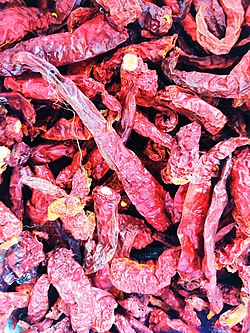
|caption = [[Byadagi chilli]] |
||
|native_name = |
|native_name = ಬ್ಯಾಡಗಿ |
||
|native_name_lang = kn |
|native_name_lang = kn |
||
|other_name = |
|other_name = |
||
| Line 14: | Line 14: | ||
| subdivision_name = {{flagu|India}} |
| subdivision_name = {{flagu|India}} |
||
|subdivision_type1 = State |
|subdivision_type1 = State |
||
|subdivision_name1 = [[ |
|subdivision_name1 = [[Karnataka]] |
||
|subdivision_type2 = [[ |
|subdivision_type2 = [[Region]] |
||
|subdivision_name2 = [[ |
|subdivision_name2 = [[Bayalu Seeme]] |
||
|subdivision_type3 = [[List of districts of Karnataka|District]] |
|||
|subdivision_name3 = [[Haveri district|Haveri]] |
|||
|pushpin_map = India Karnataka |
|pushpin_map = India Karnataka |
||
|pushpin_map_caption = Location of |
|pushpin_map_caption = Location of Byadagi in Karnataka |
||
|coordinates = {{coord|14|41|17.93|N|75|29|18.98|E|region:IN-KN|format=dec|display=inline,title}} |
|coordinates = {{coord|14|41|17.93|N|75|29|18.98|E|region:IN-KN|format=dec|display=inline,title}} |
||
|pushpin_label_position = left |
|pushpin_label_position = left |
||
| Line 28: | Line 30: | ||
|postal_code_type = [[Postal Index Number]] |
|postal_code_type = [[Postal Index Number]] |
||
|postal_code = 581106 |
|postal_code = 581106 |
||
|registration_plate = KA |
|registration_plate = KA 27 [[Haveri]] |
||
|blank1_name_sec1 = [[Communications in India|Telephone]] |
|blank1_name_sec1 = [[Communications in India|Telephone]] |
||
|blank1_info_sec1 = 91-(0)8375 |
|blank1_info_sec1 = 91-(0)8375 |
||
|website = {{URL| |
|website = {{URL|http://www.byadagitown.mrc.gov.in/en }} |
||
|footnotes = {{Reflist|group=upper-alpha}} |
|footnotes = {{Reflist|group=upper-alpha}} |
||
}} |
}} |
||
''' |
'''Byadagi''' is a popular town in [[Haveri district]], in the state of [[Karnataka]], it is agricultural business centre. |
||
The town is known for its long, red [[Byadagi chilli|Byadgi chilli]]. The areas surrounding Byadgi produce the chilli which is then dried in sunlight and sent to different markets. |
The town is known for its long, red [[Byadagi chilli|Byadgi chilli]]. The areas surrounding Byadgi produce the chilli which is then dried in sunlight and sent to different markets. |
||
Revision as of 14:14, 17 November 2022
Byadagi
ಬ್ಯಾಡಗಿ | |
|---|---|
Town | |
 | |
| Coordinates: 14°41′17.93″N 75°29′18.98″E / 14.6883139°N 75.4886056°E | |
| Country | |
| State | Karnataka |
| Region | Bayalu Seeme |
| District | Haveri |
| Languages | |
| • Official | Kannada |
| Time zone | UTC+05:30 (IST) |
| Postal Index Number | 581106 |
| Vehicle registration | KA 27 Haveri |
| Telephone | 91-(0)8375 |
| Website | www |
Byadagi is a popular town in Haveri district, in the state of Karnataka, it is agricultural business centre.
The town is known for its long, red Byadgi chilli. The areas surrounding Byadgi produce the chilli which is then dried in sunlight and sent to different markets.
Geography
Byadgi is located at 14°41′N 75°29′E / 14.68°N 75.48°E.[1] It has an average elevation of 601 meters (1971 feet).
Demographics
As of 2011[update] India census,[2] Byadgi had a population of 30,014. Males constitute 51% of the population and females 49%. Byadgi has an average literacy rate of 67%, higher than the national average of 59.5%. Male literacy is 74% and female literacy, 60%. 13% of the population is under 6 years of age.
Tourism
The sacred site, Kaginele is located in the Byadgi taluk and 15km northeast in the direction from Byadgi town. Kadaramandalagi is another sacred site which is located 6 km away from Byadgi. An idol of Lord Kantesha (Hanuman) is present in the temple.
Education
Byadagi has a number of government and private schools and colleges which offer courses in PU, degree and other technical courses. [citation needed]
References
- ^ Falling Rain Genomics, Inc – Byadagi
- ^ "Census of India 2001: Data from the 2001 Census, including cities, villages and towns (Provisional)". Census Commission of India. Archived from the original on 16 June 2004. Retrieved 1 November 2008.

