Pomichna: Difference between revisions
m Set "punct" to "." in {{Ua-pop-est2021}} per AWB request |
population update |
||
| Line 53: | Line 53: | ||
| elevation_m = |
| elevation_m = |
||
| population_footnotes = |
| population_footnotes = |
||
| population_total = |
| population_total = 8608 |
||
| population_as_of = |
| population_as_of = 2022 |
||
| population_density_km2 = auto |
| population_density_km2 = auto |
||
| population_demonym = |
| population_demonym = |
||
| Line 70: | Line 70: | ||
| footnotes = |
| footnotes = |
||
}} |
}} |
||
'''Pomichna''' ({{Lang-uk|Помічна}}) is a city in [[Novoukrainka Raion]], [[Kirovohrad Oblast]] ([[oblast|region]]) of [[Ukraine]]. It hosts the administration of [[Pomichna urban hromada]], one of the [[hromada]]s of Ukraine.<ref name="admreform_2020_pomichna">{{cite web |title=Помичнянская громада |url=https://gromada.info/ru/obschina/pomichnyanska/ |publisher=Портал об'єднаних громад України |language=ru}}</ref> Population: {{Ua-pop- |
'''Pomichna''' ({{Lang-uk|Помічна}}) is a city in [[Novoukrainka Raion]], [[Kirovohrad Oblast]] ([[oblast|region]]) of [[Ukraine]]. It hosts the administration of [[Pomichna urban hromada]], one of the [[hromada]]s of Ukraine.<ref name="admreform_2020_pomichna">{{cite web |title=Помичнянская громада |url=https://gromada.info/ru/obschina/pomichnyanska/ |publisher=Портал об'єднаних громад України |language=ru}}</ref> Population: {{Ua-pop-est2022|8,608|punct=.}} |
||
== History == |
== History == |
||
Revision as of 15:45, 2 January 2023
Pomichna
Помічна | |
|---|---|
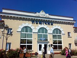
 Pomichna railway station | |
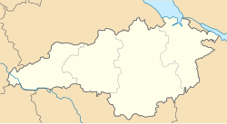
| Coordinates: 48°15′N 31°25′E / 48.25°N 31.42°E | |
| Country | |
| Oblast | |
| Raion | Novoukrainka Raion |
| Population (2022) | |
• Total | 8,608 |
Pomichna (Template:Lang-uk) is a city in Novoukrainka Raion, Kirovohrad Oblast (region) of Ukraine. It hosts the administration of Pomichna urban hromada, one of the hromadas of Ukraine.[1] Population: 8,608 (2022 estimate).[2]
History
In 1775, after the liquidation of Zaporozhian Sich, the Cossacks, leaving the Cossack winter quarters, settled in the slobodas, turning into peasants.
One of these liberties was the modern village of Pomichna. Near the fortress of St. Elizaveta was garrisoned by Zaporozhian Cossacks. The village of Pomichna provided the garrison with food, thereby providing help, "pomich", and hence the name of the settlement "Pomichna".
Former settlement in Kherson Governorate of the Russian Empire.
During World War II, the settlement was occupied by German troops. On March 18, 1944, Pomichna was liberated from the Nazi occupiers by the troops of the 2nd Ukrainian Front.
On May 14, 1967, by the Decree of the Presidium of the Verkhovna Rada of the Ukrainian SSR, Pomichna received the status of a city.[3]
In 1989, population was 12322 people.[4]
In 2013, population was 9210 people.[5]
Until 18 July 2020, Pomichna belonged to Dobrovelychkivka Raion. The raion was abolished in July 2020, as part of the administrative reform of Ukraine, which reduced the number of raions of Kirovohrad Oblast to four. The area of Dobrovelychkivka Raion was merged into Novoukrainka Raion.[6][7]
Climate
| Climate data for Pomichna (1981–2010) | |||||||||||||
|---|---|---|---|---|---|---|---|---|---|---|---|---|---|
| Month | Jan | Feb | Mar | Apr | May | Jun | Jul | Aug | Sep | Oct | Nov | Dec | Year |
| Mean daily maximum °C (°F) | −1.1 (30.0) |
−0.1 (31.8) |
6.0 (42.8) |
14.8 (58.6) |
21.4 (70.5) |
24.5 (76.1) |
26.8 (80.2) |
26.5 (79.7) |
20.4 (68.7) |
13.6 (56.5) |
5.4 (41.7) |
0.3 (32.5) |
13.2 (55.8) |
| Daily mean °C (°F) | −3.8 (25.2) |
−3.2 (26.2) |
1.6 (34.9) |
9.2 (48.6) |
15.4 (59.7) |
18.7 (65.7) |
20.9 (69.6) |
20.3 (68.5) |
14.8 (58.6) |
8.7 (47.7) |
2.1 (35.8) |
−2.3 (27.9) |
8.5 (47.3) |
| Mean daily minimum °C (°F) | −6.4 (20.5) |
−6.2 (20.8) |
−1.9 (28.6) |
4.2 (39.6) |
9.7 (49.5) |
13.4 (56.1) |
15.2 (59.4) |
14.6 (58.3) |
9.8 (49.6) |
4.7 (40.5) |
−0.6 (30.9) |
−4.8 (23.4) |
4.3 (39.7) |
| Average precipitation mm (inches) | 29.7 (1.17) |
29.5 (1.16) |
31.5 (1.24) |
34.4 (1.35) |
49.6 (1.95) |
80.5 (3.17) |
63.9 (2.52) |
61.5 (2.42) |
54.8 (2.16) |
38.6 (1.52) |
37.4 (1.47) |
34.5 (1.36) |
545.9 (21.49) |
| Average precipitation days (≥ 1.0 mm) | 7.1 | 6.5 | 6.6 | 6.2 | 7.5 | 9.2 | 6.6 | 5.9 | 6.1 | 5.1 | 6.3 | 6.8 | 79.9 |
| Average relative humidity (%) | 86.8 | 84.1 | 78.2 | 66.4 | 62.9 | 68.5 | 66.9 | 64.7 | 72.0 | 78.4 | 86.9 | 88.7 | 75.4 |
| Source: World Meteorological Organization[8] | |||||||||||||
References
- ^ "Помичнянская громада" (in Russian). Портал об'єднаних громад України.
- ^ Чисельність наявного населення України на 1 січня 2022 [Number of Present Population of Ukraine, as of January 1, 2022] (PDF) (in Ukrainian and English). Kyiv: State Statistics Service of Ukraine. Archived (PDF) from the original on 4 July 2022.
- ^ "Коли зійде щаслива зірка Помічної?".
- ^ Всесоюзная перепись населения 1989 г. Численность городского населения союзных республик, их территориальных единиц, городских поселений и городских районов по полу
- ^ Чисельність наявного населення України на 1 січня 2013 року. Державна служба статистики України. Київ, 2013. стор.71
- ^ "Про утворення та ліквідацію районів. Постанова Верховної Ради України № 807-ІХ". Голос України (in Ukrainian). 2020-07-18. Retrieved 2020-10-03.
- ^ "Нові райони: карти + склад" (in Ukrainian). Міністерство розвитку громад та територій України.
- ^ "World Meteorological Organization Climate Normals for 1981–2010". World Meteorological Organization. Archived from the original on 17 July 2021. Retrieved 17 July 2021.


