Obingwa: Difference between revisions
Appearance
Content deleted Content added
add {{Use Nigerian English}} |
|||
| Line 1: | Line 1: | ||
{{Use Nigerian English|date=January 2023}} |
|||
{{Infobox settlement |
{{Infobox settlement |
||
| official_name = Obingwa |
| official_name = Obingwa |
||
| Line 30: | Line 31: | ||
| government_footnotes = |
| government_footnotes = |
||
| government_type = [[Democracy|Democratic]] |
| government_type = [[Democracy|Democratic]] |
||
| leader_title = [[Chairman (Nigeria)| |
| leader_title = [[Chairman (Nigeria)|Chairman]] |
||
| established_title = 21, August 1991 |
| established_title = 21, August 1991 |
||
| leader_name = |
| leader_name = |
||
| Line 98: | Line 99: | ||
==External links== |
==External links== |
||
*{{Official website|www.uzopedia.wordpress.com}} |
*{{Official website|www.uzopedia.wordpress.com}} |
||
| Line 105: | Line 105: | ||
{{DEFAULTSORT:Uzomedia}} |
{{DEFAULTSORT:Uzomedia}} |
||
[[Category:Local Government Areas in Abia State]] |
[[Category:Local Government Areas in Abia State]] |
||
{{AbiaNG-geo-stub}} |
{{AbiaNG-geo-stub}} |
||
Revision as of 22:31, 28 January 2023
Obingwa
Obiomangwa | |
|---|---|
 | |
| Country | |
| State | Abia State |
| Capital | Mgboko |
| Government | |
| • Type | Democratic |
| Area | |
• Total | 153 sq mi (395 km2) |
| Population (2006) | |
• Total | 181,439 |
| Time zone | UTC+1 (WAT) |
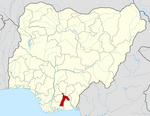
Obingwa is a Local Government Area of Abia State, Nigeria. Its headquarters are in the town of Mgboko.
It has an area of 395 km2 and a population of 181,439 at the 2006 census.
The postal code of the area is 453.[1]
Populated areas
- Mgboko
- Abayi Okoroato
- Abala-Ibeme
- Mgboko Ngwa
- Ohanze
- Owoelu
- Ndiakata
- Nlagu
- Oberete
- Umuoha
- Obete-Ukwu
- Onicha-Ngwa
- Umuiroma
See also
References
- ^ "Post Offices- with map of LGA". NIPOST. Archived from the original on 2009-09-26. Retrieved 2009-10-20.
External links
5°09′19″N 7°27′26″E / 5.1554°N 7.4571°E

