MS Prinsendam (1972): Difference between revisions
General clean-up (organization, reduced jargon and unexplained abbreviations, corrected anachronistic terminology, standardized date format, etc.). |
Nauticalized phrasing. |
||
| Line 64: | Line 64: | ||
''Prinsendam'' was in the [[Gulf of Alaska]] approximately {{convert|120|nmi|lk=in|0}} south of [[Yakutat, Alaska|Yakutat]], [[Alaska]], at midnight on 4 October 1980 when a fire broke out in the [[engine room]]. Her [[Sea captain|master]], Cornelis Dirk Wabeke (13 April 1928 – 16 August 2011), declared the fire out of control one hour later and ''Prinsendam'' sent a radio call requesting immediate assistance. The [[United States Coast Guard]] at Communications Station Kodiak in [[Kodiak, Alaska|Kodiak]], Alaska, requested that ''Prinsendam'' send out an [[SOS]] to alert other vessels in the area, but Wabeke declined. Chief Radio Officer Jack van der Zee sent one out anyway about a half-hour later.<ref>{{cite web |url=http://www.qsl.net/n1ea/sos.jpg |title=Manuscript log of supertanker ''Williamsburgh'' |date=4 October 1980 |accessdate=19 December 2019 |url-status=live |archive-url=https://web.archive.org/web/20161201203822/http://www.qsl.net/n1ea/sos.jpg |archivedate=1 December 2016 }}</ref> |
''Prinsendam'' was in the [[Gulf of Alaska]] approximately {{convert|120|nmi|lk=in|0}} south of [[Yakutat, Alaska|Yakutat]], [[Alaska]], at midnight on 4 October 1980 when a fire broke out in the [[engine room]]. Her [[Sea captain|master]], Cornelis Dirk Wabeke (13 April 1928 – 16 August 2011), declared the fire out of control one hour later and ''Prinsendam'' sent a radio call requesting immediate assistance. The [[United States Coast Guard]] at Communications Station Kodiak in [[Kodiak, Alaska|Kodiak]], Alaska, requested that ''Prinsendam'' send out an [[SOS]] to alert other vessels in the area, but Wabeke declined. Chief Radio Officer Jack van der Zee sent one out anyway about a half-hour later.<ref>{{cite web |url=http://www.qsl.net/n1ea/sos.jpg |title=Manuscript log of supertanker ''Williamsburgh'' |date=4 October 1980 |accessdate=19 December 2019 |url-status=live |archive-url=https://web.archive.org/web/20161201203822/http://www.qsl.net/n1ea/sos.jpg |archivedate=1 December 2016 }}</ref> |
||
[[File:Een model van de Prinsendam, Bestanddeelnr 931-8039.jpg|left|thumb|224x224px|A model of |
[[File:Een model van de Prinsendam, Bestanddeelnr 931-8039.jpg|left|thumb|224x224px|A model of MS ''Prinsendam''.]] |
||
U.S. Coast Guard, [[United States Air Force]] [[Air Rescue Service]], and [[Canadian Armed Forces]] [[Royal Canadian Air Force|Air Command]] [[CH-113]] helicopters, which had greater range, rescued the passengers and crew. The rescue took place during a period of steadily deteriorating weather. |
U.S. Coast Guard, [[United States Air Force]] [[Air Rescue Service]], and [[Canadian Armed Forces]] [[Royal Canadian Air Force|Air Command]] [[CH-113]] helicopters, which had greater range, rescued the passengers and crew. The rescue took place during a period of steadily deteriorating weather. |
||
Revision as of 11:56, 8 July 2023
 MS Prinsendam on fire off Alaska, 1980
| |
| History | |
|---|---|
| Name | Prinsendam |
| Operator | Holland America Line |
| Builder | De Merwede in Hardinxveld-Giessendam, Netherlands |
| Cost | US$27 million |
| Launched | 7 July 1972 |
| Completed | 1973 |
| Maiden voyage | 1973 |
| In service | 1973 |
| Out of service | October 4, 1980 |
| Identification | IMO number: 7224734 |
| Fate | Sank 11 October 1980 |
| General characteristics | |
| Length | 427 ft (130 m) |
| Capacity | 350 passengers |
| Crew | 200 |
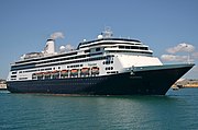
MS Prinsendam, was a Holland-America Line cruise ship built at Shipyard de Merwede in the Netherlands in 1973. She was 427 feet (130 m) long and typically carried about 350 passengers and 200 crew members.
Sinking
Prinsendam was in the Gulf of Alaska approximately 120 nautical miles (222 km; 138 mi) south of Yakutat, Alaska, at midnight on 4 October 1980 when a fire broke out in the engine room. Her master, Cornelis Dirk Wabeke (13 April 1928 – 16 August 2011), declared the fire out of control one hour later and Prinsendam sent a radio call requesting immediate assistance. The United States Coast Guard at Communications Station Kodiak in Kodiak, Alaska, requested that Prinsendam send out an SOS to alert other vessels in the area, but Wabeke declined. Chief Radio Officer Jack van der Zee sent one out anyway about a half-hour later.[1]

U.S. Coast Guard, United States Air Force Air Rescue Service, and Canadian Armed Forces Air Command CH-113 helicopters, which had greater range, rescued the passengers and crew. The rescue took place during a period of steadily deteriorating weather.
The U.S. Coast Guard cutters USCGC Boutwell (WHEC-719), USCGC Mellon (WHEC-717), and USCGC Woodrush (WLB-407) responded in concert with other vessels in the area, and the American tankers Sohio Intrepid and Williamsburgh assisted on scene. Williamsburgh served a vital role as a communications platform and was the first vessel to arrive on scene and take passengers on board. The Sohio Intrepid served as a platform for one of the U.S. Air Force helicopters that was unable to refuel in flight. Two U.S. Air Force pararescuemen went aboard one of Prinsendam′s lifeboats, and this boat was the last rescued after a lookout aboard Woodrush, Seaman Louis Roderick, sighted a flare from the boat and word of the sighting was relayed to the on-scene commander aboard Boutwell.
The rescue is particularly noteworthy because of the distance traveled by the rescuers, the coordination of independent organizations, and the fact that all 520 passengers and crew were rescued without loss of life or serious injury.[2]
Prinsendam finally capsized and sank on 11 October 1980.
References
- ^ "Manuscript log of supertanker Williamsburgh". 4 October 1980. Archived from the original on 1 December 2016. Retrieved 19 December 2019.
- ^ "Top Ten Coast Guard Rescues". Coast Guard News. Jul 31, 2007. Archived from the original on May 27, 2014. Retrieved 19 December 2019.
External links
- David J. Ring, Jr., N1EA, Radio Officer, "T/T WILLIAMSBURGH", "SOS from ms PRINSENDAM - Marine Radio History - Morse Code", August 17, 2018.

