Mandritsara: Difference between revisions
No edit summary |
river, postal code |
||
| Line 105: | Line 105: | ||
|elevation_ft = |
|elevation_ft = |
||
<!-- Area/postal codes & others --------> |
<!-- Area/postal codes & others --------> |
||
|postal_code_type = |
|postal_code_type = Postal code |
||
|postal_code = |
|postal_code = 415 |
||
|area_code = |
|area_code = |
||
|blank_name = |
|blank_name = |
||
| Line 117: | Line 117: | ||
'''Mandritsara''' {{IPA-mg|maɳɖʐiˈtsarə̥|}} is a city and commune (commune urbain, {{lang-mg|kaominina}}) in northern [[Madagascar]]. It belongs to the [[Districts of Madagascar|district]] of [[Mandritsara District|Mandritsara]], which is a part of [[Sofia Region]]. The population of the commune was estimated to be approximately 17,000 in 2001 commune [[census]].<ref name="pop"/> |
'''Mandritsara''' {{IPA-mg|maɳɖʐiˈtsarə̥|}} is a city and commune (commune urbain, {{lang-mg|kaominina}}) in northern [[Madagascar]]. It belongs to the [[Districts of Madagascar|district]] of [[Mandritsara District|Mandritsara]], which is a part of [[Sofia Region]]. The population of the commune was estimated to be approximately 17,000 in 2001 commune [[census]].<ref name="pop"/> |
||
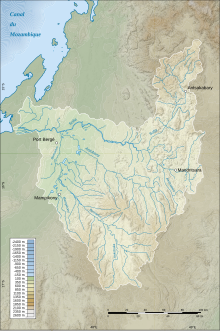
[[File:Carte bassin Sofia.svg|thumb|left|Sofia river bassin, Mandritsara on the right]] |
|||
Farming and raising livestock provides employment for 40% and 35% of the working population. The most important crop is [[rice]], while other important products are [[peanut]]s and [[cassava]]. Services provide employment for 25% of the population.<ref name="pop">{{cite web |
Farming and raising livestock provides employment for 40% and 35% of the working population. The most important crop is [[rice]], while other important products are [[peanut]]s and [[cassava]]. Services provide employment for 25% of the population.<ref name="pop">{{cite web |
||
| url=http://www.ilo.cornell.edu/ilo/data.html |
| url=http://www.ilo.cornell.edu/ilo/data.html |
||
| Line 136: | Line 136: | ||
* Mandritsara is served by a local [[Mandritsara Airport|airport]]. |
* Mandritsara is served by a local [[Mandritsara Airport|airport]]. |
||
==River== |
|||
Mandritsara lies on the [[Mangarahara]] river, an affluent of the [[Sofia River]]. |
|||
== References and notes == |
== References and notes == |
||
{{reflist}} |
{{reflist}} |
||
Revision as of 01:24, 23 August 2023
Mandritsara | |
|---|---|
| Coordinates: 15°50′S 48°49′E / 15.833°S 48.817°E | |
| Country | |
| Region | Sofia |
| District | Mandritsara |
| Elevation | 322 m (1,056 ft) |
| Population (2001)[2] | |
• Total | 17,000 |
| Time zone | UTC3 (EAT) |
| Postal code | 415 |
Mandritsara [maɳɖʐiˈtsarə̥] is a city and commune (commune urbain, Template:Lang-mg) in northern Madagascar. It belongs to the district of Mandritsara, which is a part of Sofia Region. The population of the commune was estimated to be approximately 17,000 in 2001 commune census.[2]

Farming and raising livestock provides employment for 40% and 35% of the working population. The most important crop is rice, while other important products are peanuts and cassava. Services provide employment for 25% of the population.[2]
Education
In addition to primary schooling the town offers secondary education at both junior and senior levels. The Social Sciences Training and Research Unit (UFRSS) is the Mandritsara branch of the University of Mahajanga.
Healthcare
Mandritsara is home to Hopitaly Vaovao Mahafaly, a hospital which aims to show God’s love to those in need and to proclaim the Gospel of Jesus Christ to every patient. It has 57 inpatient beds, maternity facilities, and the only operating theatre for a 200km radius.
Transport
River
Mandritsara lies on the Mangarahara river, an affluent of the Sofia River.
References and notes
- ^ Estimated based on DEM data from Shuttle Radar Topography Mission
- ^ a b c "ILO census data". Cornell University. 2002. Retrieved 2008-02-28.
15°50′S 48°49′E / 15.833°S 48.817°E


