Waikanae River: Difference between revisions
add |
Citation bot (talk | contribs) Removed parameters. | Use this bot. Report bugs. | #UCB_CommandLine |
||
| Line 14: | Line 14: | ||
== Bridges == |
== Bridges == |
||
The first bridge was built about 1885 by the [[Wellington and Manawatu Railway Company]]. It was a 3-span timber truss bridge.<ref>{{Cite web|last=|first=|date=|title=Wellington and Manawatu Railway bridge over Waikanae river about 1885|url=https://natlib.govt.nz/records/22693186 |
The first bridge was built about 1885 by the [[Wellington and Manawatu Railway Company]]. It was a 3-span timber truss bridge.<ref>{{Cite web|last=|first=|date=|title=Wellington and Manawatu Railway bridge over Waikanae river about 1885|url=https://natlib.govt.nz/records/22693186|access-date=2021-04-17|website=National Library of New Zealand|language=en}}</ref> In 1925 a fence of old rails was built to protect the bridge, backed by fifteen old square iron tanks (sent from [[East Town Railway Workshops|East Town]]), filled with river bed stones.<ref name=":23">{{Cite web|last=|first=|date=|title=Stations|url=http://railheritage.org.nz/assets/Heritage_listings.pdf|archive-url=|archive-date=|access-date=2020-08-10|website=NZR Rolling Stock Lists|language=en}}</ref> By 1938 the bridge had been rebuilt in steel and concrete.<ref>{{Cite web|title=Wellington-Napier Express crossing the bridge at Waikanae|url=http://nzetc.victoria.ac.nz/tm/scholarly/Gov12_12Rail-fig-Gov12_12Rail041a.html|access-date=2021-04-17|website=nzetc.victoria.ac.nz}}</ref> |
||
The next bridge was built nearby and opened in 1901. It was also 3 timber spans and {{Convert|247|ft|abbr=on}} long.<ref>{{Cite web|date=30 Sep 1901|title=WAIKANAE BRIDGE. THE OPENING CEREMONY. EVENING POST|url=https://paperspast.natlib.govt.nz/newspapers/EP19010930.2.49 |
The next bridge was built nearby and opened in 1901. It was also 3 timber spans and {{Convert|247|ft|abbr=on}} long.<ref>{{Cite web|date=30 Sep 1901|title=WAIKANAE BRIDGE. THE OPENING CEREMONY. EVENING POST|url=https://paperspast.natlib.govt.nz/newspapers/EP19010930.2.49|access-date=2021-04-17|website=paperspast.natlib.govt.nz}}</ref> |
||
The latest bridge is on the [[Kāpiti Expressway]]. It is a single [[T-beam#Reinforced concrete T-beams|T-beam]], {{Convert|35|m|abbr=on}} above the river, with a {{Convert|39|m|abbr=on}} span.<ref>{{Cite web|date=Oct 2018|title=REFINEMENT ERA FOR PRESTRESSED BRIDGES IN NEW ZEALAND (2003 - TODAY)|url=https://cdn.ymaws.com/concretenz.org.nz/resource/resmgr/docs/conf/2018/s6_p2.pdf |
The latest bridge is on the [[Kāpiti Expressway]]. It is a single [[T-beam#Reinforced concrete T-beams|T-beam]], {{Convert|35|m|abbr=on}} above the river, with a {{Convert|39|m|abbr=on}} span.<ref>{{Cite web|date=Oct 2018|title=REFINEMENT ERA FOR PRESTRESSED BRIDGES IN NEW ZEALAND (2003 - TODAY)|url=https://cdn.ymaws.com/concretenz.org.nz/resource/resmgr/docs/conf/2018/s6_p2.pdf}}</ref> |
||
There are also a couple walking bridges built by the Kāpiti Coast District years ago on the river walking paths, such as the Otaihanga Domain Bridge.{{Citation needed|date=September 2023}} |
There are also a couple walking bridges built by the Kāpiti Coast District years ago on the river walking paths, such as the Otaihanga Domain Bridge.{{Citation needed|date=September 2023}} |
||
Revision as of 09:11, 27 September 2023
This article needs additional citations for verification. (March 2007) |


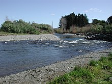
Waikanae River is located on the Kāpiti Coast in the North Island of New Zealand.
The river drains the western flanks of the Tararua Ranges around Reikorangi and the Akatarawa Valley, then passes to the south of the town of Waikanae to the north of the river and Otaihanga/ Paraparaumu to the south before entering the Tasman Sea at Waikanae - Paraparaumu Beach. Tributaries include the Maungakotukutuku Stream, Ngatiawa River, and Reikorangi Stream. The estuary of the river is a significant reserve providing shelter and habitat for local and migratory seabirds. It also provides a major recreational location, both for residents and tourists. Walking and cycling tracks are present on both sides of the river, leading from Waikanae Beach and Otaihanga Domain to the old state highway bridge just south Waikanae.
Water up to a maximum amount is taken out of the river as water supply for Waikanae and Paraparaumu. This sometimes leads to water restrictions if the river runs low, however in January 2005 the river burst its banks after heavy rain. The river has good water quality and high aquatic biodiversity, but there are occasional blooms of toxic cyanobacteria after prolonged periods of low flow during hot, dry weather.[citation needed]
There have been multiple instances in earlier years (2020, 2021) where the river back has burst, leading to several floods in the elevated areas south of the river. It came with heavy rainfall and heavy storms and cyclones in the area.[citation needed]
The estuary of the Waikanae River is ever changing, with major and minor storms disrupting the banks and causing it to change shape. Prior to storms in 2016/17, the river seamlessly transitioned into the sea, but after storms, long sandbars and banks have caused the river to take an winding path to reach the Tasman Sea.[citation needed]
Bridges
The first bridge was built about 1885 by the Wellington and Manawatu Railway Company. It was a 3-span timber truss bridge.[1] In 1925 a fence of old rails was built to protect the bridge, backed by fifteen old square iron tanks (sent from East Town), filled with river bed stones.[2] By 1938 the bridge had been rebuilt in steel and concrete.[3]
The next bridge was built nearby and opened in 1901. It was also 3 timber spans and 247 ft (75 m) long.[4]
The latest bridge is on the Kāpiti Expressway. It is a single T-beam, 35 m (115 ft) above the river, with a 39 m (128 ft) span.[5]
There are also a couple walking bridges built by the Kāpiti Coast District years ago on the river walking paths, such as the Otaihanga Domain Bridge.[citation needed]
History
In December 2017 the part of the river near State Highway 1, a popular swimming location, was filled with thumb tacks.[6]
References
- ^ "Wellington and Manawatu Railway bridge over Waikanae river about 1885". National Library of New Zealand. Retrieved 17 April 2021.
- ^ "Stations" (PDF). NZR Rolling Stock Lists. Retrieved 10 August 2020.
- ^ "Wellington-Napier Express crossing the bridge at Waikanae". nzetc.victoria.ac.nz. Retrieved 17 April 2021.
- ^ "WAIKANAE BRIDGE. THE OPENING CEREMONY. EVENING POST". paperspast.natlib.govt.nz. 30 September 1901. Retrieved 17 April 2021.
- ^ "REFINEMENT ERA FOR PRESTRESSED BRIDGES IN NEW ZEALAND (2003 - TODAY)" (PDF). October 2018.
- ^ Maxwell, Joel (12 December 2017). "Kāpiti Coast swimming hole booby-trapped with hundreds of thumb tacks". Stuff. Retrieved 1 September 2023.
External links
- Photo of the Waikanae River from the Cyclopaedia of New Zealand c1897
- Photo of the Waikanae rail and road bridges and express train on bridge c1939
- Photo of the Waikanae rail and road bridges and express train leaving bridge c1938
- South bank of Waikanae River with strata identified
- 132793862 Waikanae River on OpenStreetMap
