Karaçoban: Difference between revisions
Appearance
Content deleted Content added
infobox, neighbourhoods, references |
Vartolu3566 (talk | contribs) No edit summary Tags: Visual edit Mobile edit Mobile web edit |
||
| Line 3: | Line 3: | ||
| name = Karaçoban |
| name = Karaçoban |
||
| image_skyline = |
| image_skyline = |
||
| image_caption = |
| image_caption = |
||
| image_shield = |
|||
| image_logo = Karacobanbelediyesilogo.png |
|||
| image_map = Erzurum location Karaçoban.png |
| image_map = Erzurum location Karaçoban.png |
||
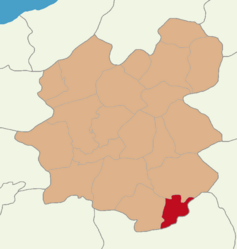
| map_caption = Map showing Karaçoban District in Erzurum Province |
| map_caption = Map showing Karaçoban District in Erzurum Province |
||
Revision as of 20:07, 27 September 2023
Karaçoban | |
|---|---|
 Map showing Karaçoban District in Erzurum Province | |
| Coordinates: 39°21′03″N 42°06′43″E / 39.35083°N 42.11194°E | |
| Country | Turkey |
| Province | Erzurum |
| Government | |
| • Mayor | Halit Uğun (HDP) |
Area | 571 km2 (220 sq mi) |
| Elevation | 1,550 m (5,090 ft) |
| Population (2022)[1] | 22,250 |
| • Density | 39/km2 (100/sq mi) |
| Time zone | UTC+3 (TRT) |
| Postal code | 25610 |
| Area code | 0442 |
| Climate | Dfb |
| Website | www |
Karaçoban (Template:Lang-ku)[2] is a municipality and district of Erzurum Province, Turkey.[3] Its area is 571 km2,[4] and its population is 22,250 (2022).[1]
Composition
There are 27 neighbourhoods in Karaçoban District:[5]
References
- ^ a b "Address-based population registration system (ADNKS) results dated 31 December 2022, Favorite Reports" (XLS). TÜİK. Retrieved 12 July 2023.
- ^ İbrahim Sediyani (2009). Adını arayan coğrafya. Özedönüş Yayınları. p. 185. ISBN 9786054296002.
- ^ Büyükşehir İlçe Belediyesi, Turkey Civil Administration Departments Inventory. Retrieved 12 July 2023.
- ^ "İl ve İlçe Yüz ölçümleri". General Directorate of Mapping. Retrieved 12 July 2023.
- ^ Mahalle, Turkey Civil Administration Departments Inventory. Retrieved 12 July 2023.


