Manchac Swamp Bridge: Difference between revisions
Changing short description from "Bridge through the Manchac Swamp in the United States state of Louisiana." to "Bridge in Louisiana, US" |
m v2.05b - Fix errors for CW project (Category before last heading) |
||
| Line 33: | Line 33: | ||
[[File:Lake Pontchartrain by Sentinel-2.jpg|thumb|A satellite view of the Manchac Swamp bridge (to the left) and the nearby [[Lake_Pontchartrain_Causeway|Pontchartrain bridge]]]] |
[[File:Lake Pontchartrain by Sentinel-2.jpg|thumb|A satellite view of the Manchac Swamp bridge (to the left) and the nearby [[Lake_Pontchartrain_Causeway|Pontchartrain bridge]]]] |
||
| ⚫ | |||
==See also== |
==See also== |
||
| Line 45: | Line 44: | ||
{{Reflist}} |
{{Reflist}} |
||
| ⚫ | |||
[[Category:Bridges completed in 1979]] |
[[Category:Bridges completed in 1979]] |
||
[[Category:Buildings and structures in St. John the Baptist Parish, Louisiana]] |
[[Category:Buildings and structures in St. John the Baptist Parish, Louisiana]] |
||
Revision as of 00:44, 4 October 2023
Manchac Swamp Bridge | |
|---|---|
 | |
| Coordinates | 30°18′11″N 90°24′21″W / 30.302946°N 90.405807°W |
| Carries | |
| Crosses | Manchac Swamp |
| Locale | St. John the Baptist Parish / Tangipahoa Parish, Louisiana, USA |
| Other name(s) | I-55 Manchac Swamp Crossing |
| Maintained by | LA DOTD |
| Characteristics | |
| Total length | 22.8 miles (36.7 km) |
| Width | 312 feet (95 m) |
| History | |
| Opened | 1979[1] |
| Location | |
 | |
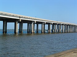
The Manchac Swamp Bridge is a twin concrete trestle bridge near Manchac in the US state of Louisiana.[1] With a total length of 22.80 miles (36.69 km),[2][3] it is one of the longest bridges in the world over water and is the longest bridge on the Interstate Highway System. Some claim it is the longest toll-free road bridge in the world.[4] The bridge carries Interstate 55 and U.S. Route 51 over the Manchac Swamp in Louisiana and represents a third of the highway's approximately 66 miles (106 km) in Louisiana. Opening in 1979,[1] its piles were driven 250 feet (76 m) beneath the swamp and with the cost of the span being $7 million per mile ($4.3 million/km) (equivalent to $23.7 million per mile ($15 million/km) in 2023[5]) to complete.[6]

See also
 Transport portal
 Engineering portal
 United States portal
- List of bridges in the United States
- List of longest bridges
References
- ^ a b c Melaragno, Michele G. (1998). Preliminary Design of Bridges for Architects and Engineers. CRC Press. p. 377. ISBN 978-0-8247-0184-0. Retrieved June 20, 2010.
- ^ "Manchac Swamp Bridge". Atlas Obscura. Retrieved May 2, 2019.
- ^ "Manchac Swamp Bridge, one of the longest bridges in the world over water". www.dangerousroads.org. Retrieved March 7, 2022.
- ^ "Longest Bridges in North America". WorldAtlas. August 1, 2017. Retrieved March 7, 2022.
- ^ Johnston, Louis; Williamson, Samuel H. (2023). "What Was the U.S. GDP Then?". MeasuringWorth. Retrieved November 30, 2023. United States Gross Domestic Product deflator figures follow the MeasuringWorth series.
- ^ Loh, Jules (June 8, 1977). "Louisiana 'oasis' is cypress-paneled". The Tuscaloosa News. Tuscaloosa, Alabama. p. 6. Retrieved July 20, 2010.
- U.S. Route 51
- Bridges completed in 1979
- Buildings and structures in St. John the Baptist Parish, Louisiana
- Buildings and structures in Tangipahoa Parish, Louisiana
- Transportation in Tangipahoa Parish, Louisiana
- Road bridges in Louisiana
- Interstate 55
- Bridges on the Interstate Highway System
- Transportation in St. John the Baptist Parish, Louisiana
- Concrete bridges in the United States
- Trestle bridges in the United States
- Southern United States bridge (structure) stubs
- Louisiana building and structure stubs
- Louisiana transportation stubs
