Pelėdnagiai Eldership: Difference between revisions
Appearance
Content deleted Content added
No edit summary Tags: Mobile edit Mobile web edit |
No edit summary Tags: Mobile edit Mobile web edit |
||
| Line 1: | Line 1: | ||
{{Infobox settlement<!--more fields are available for this Infobox--See Template:Infobox Settlement--> |
{{Infobox settlement<!--more fields are available for this Infobox--See Template:Infobox Settlement--> |
||
|official_name = Pelėdnagiai |
|official_name = Pelėdnagiai Sen |
||
|native_name = |
|native_name = Pelėdnagių seniunyja |
||
|native_name_lang = lt |
|native_name_lang = lt |
||
|settlement_type = [[Elderships of Lithuania|Eldership]] |
|settlement_type = [[Elderships of Lithuania|Eldership]] |
||
Revision as of 13:10, 29 November 2023
Pelėdnagiai Sen
Pelėdnagių seniunyja | |
|---|---|
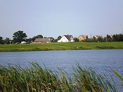
 Pamėkliai village and the Labūnava Reservoir | |
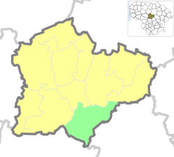
 Location of Pelėdnagiai Eldership | |
| Country | |
| Ethnographic region | Aukštaitija |
| County | |
| Municipality | |
| Administrative centre | Pelėdnagiai |
| Area | |
• Total | 141 km2 (54 sq mi) |
| Population (2011)[2] | |
• Total | 3,780 |
| • Density | 27/km2 (69/sq mi) |
| Time zone | UTC+2 (EET) |
| • Summer (DST) | UTC+3 (EEST) |
Pelėdnagiai Eldership (Template:Lang-lt) is a Lithuanian eldership, located in the south eastern part of Kėdainiai District Municipality.
Eldership was created from the Pelėdnagiai selsovet in 1993.
Geography
The territory of Pelėdnagiai Eldership is located mostly in the Nevėžis Plain and the Nevėžis river valley. Relief is mostly flat, cultivated as agriculture lands. Forests cover about 40 % of the eldership.[1]
- Rivers: Nevėžis, Barupė, Urka, Mėkla, Lankesa, Ašarėna
- Lakes and ponds: Labūnava Reservoir.
- Forests: Labūnava Forest.
- Protected areas: Barupė Hydrographical Sanctuary, Lankesa Botanical Sanctuary, Pelėdnagiai Botanical Sanctuary, Labūnava Forest Biosphere Polygon.
Places of interest
- Catholic church of the Divine in Labūnava
- Juciūnai cemetery chapel
- Aukupėnai cemetery tomb-chapel
- Labūnava manor tower
- Gelnai wayside chapel
- Ancient burial site in Nociūnai and former cemetery site in Pašiliai
- Soviet mosaic the "Land Improvers" in Pelėdnagiai
Populated places
Following settlements are located in the Pelėdnagiai Eldership (as for the 2011 census):[2]
- Villages: Akmeniai · Ansainiai · Aukupėnai · Baldinka · Beinaičiai · Bučiūnai · Eiguliai · Gelnai · Ivaniškiai · Jagminai · Juciūnai · Kačergiai · Kruopiai · Kudžioniai · Labūnava · Liaudiškiai ·Lineliai · Liogailiškiai · Medekšiai · Nartautai · Nociūnai · Pabarupys · Pacūnai · Pamėkliai · Paobelys · Pašiliai · Pėdžiai · Pelėdnagiai · Puzaičiai · Saviečiai · Serbinai · Servitgaliai · Sičioniai · Slikiai · Stašaičiai · Šilainėliai · Šilainiai · Užkapiai · Vainiūnai · Zabieliškis · Žiogaičiai
- Hamlets: Rimuoliai
- Railway station settlements: Slikių GS
- Former settlements: Činkiai
References
- ^ a b "Trumpai apie seniūniją". Kėdainių rajono savivaldybė. Retrieved 2021-01-01.
- ^ a b "2011 census". Statistikos Departamentas (Lithuania). Retrieved August 21, 2017.

