Möhrenbach: Difference between revisions
Tags: Reverted Visual edit |
Tags: Reverted Visual edit |
||
| Line 25: | Line 25: | ||
== History == |
== History == |
||
Möhrenbach was first mentioned in 1374. The village belonged to the County of Schwarzburg and was once ruled by the Lords of Berlstedt as Schwarzburg feudatories. In its early days, the village lived from mining copper, silver and lead, as well as from forestry and wood processing, and from the 17th century also from weaving and a glassworks mentioned in 1690. In 1811, a fire caused severe damage to the village. It destroyed 48 houses. |
|||
==References== |
==References== |
||
Revision as of 12:09, 5 December 2023
Möhrenbach | |
|---|---|
 Möhrenbach | |
| Coordinates: 50°37′24″N 10°59′41″E / 50.62333°N 10.99472°E | |
| Country | Germany |
| State | Thuringia |
| District | Ilm-Kreis |
| Municipality | Gehren |
| Area | |
• Total | 13.86 km2 (5.35 sq mi) |
| Elevation | 540 m (1,770 ft) |
| Population (2012-12-31) | |
• Total | 654 |
| • Density | 47/km2 (120/sq mi) |
| Time zone | UTC+01:00 (CET) |
| • Summer (DST) | UTC+02:00 (CEST) |
| Postal codes | 98708 |
| Dialling codes | 036783 |
| Vehicle registration | IK |
| Website | Möhrenbach |
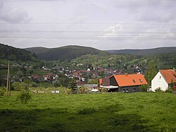
Möhrenbach is a village and a former municipality in the district Ilm-Kreis, in Thuringia, Germany. Since 31 December 2013, it is part of the municipality Gehren.
Geography
Möhrenbach is located in the Thuringian Forest. The municipal area can be divided into three strips. In the west lies the Thuringian Forest with its mountains, in the middle the broad Möhrenbach valley and in the east the Lange Berg, which already belongs to the Thuringian Slate Mountains. In the western part of the municipality lies the Wohlrose valley, above which rises the 771-metre-high Silberberg. To the east are the Möhrenbach and Ilmsenbach valleys, which join to form the Talwasser in Möhrenbach. The village of Möhrenbach lies in the central north-south valley at an altitude of around 550 meters. The landscape here is characterized by meadows interspersed with small forests and only rises again to the east to the Lange Berg, which at 808 metres is the highest point in the municipality. The forests in the west and east of the municipality are dominated by spruce trees. In the extreme south of the municipality lies the Hohe Tanne, the pass between Lange Berg and the Thuringian Forest or the Ilm and Saale catchment areas. The neighboring village to the north is Gehren, to the south behind the Hohe Tanne is Großbreitenbach and to the east beyond the Lange Berg is Gillersdorf.
History
Möhrenbach was first mentioned in 1374. The village belonged to the County of Schwarzburg and was once ruled by the Lords of Berlstedt as Schwarzburg feudatories. In its early days, the village lived from mining copper, silver and lead, as well as from forestry and wood processing, and from the 17th century also from weaving and a glassworks mentioned in 1690. In 1811, a fire caused severe damage to the village. It destroyed 48 houses.
References


