Hafizabad: Difference between revisions
Ira Leviton (talk | contribs) m Fixed a typo. |
No edit summary |
||
| Line 45: | Line 45: | ||
In 327 BC, the area around Hafizabad was reportedly well-populated during [[Alexander the Great|Alexander]]'s invasion of [[Punjab]].<ref>{{cite web |title=Hafizabad: History |url=http://punjab.gov.pk/hafizabad_history |url-status=dead |archive-url=https://web.archive.org/web/20140705115808/http://punjab.gov.pk/hafizabad_history |archive-date=5 July 2014 |access-date=5 March 2014 |publisher=Government of the Punjab}}</ref> During the [[Delhi Sultanate]] period, majority of the local population were converted to [[Islam]]. A large city was situated at the site of the present village of Mehdiabad, northwest of present day Hafizabad. Later it became unpopulated due to shortage of water and [[Pashtun people|Afghan]] incursions. The region remained uninhabited until the reign of [[Mughal emperors|Mughal emperor]] [[Akbar]], when it became the site of a [[Mahal (palace)|Mahal]] as documented in ''[[Ain-i-Akbari]]''.<ref name="IGI">{{Cite web |title=Imperial Gazetteer2 of India, Volume 13, page 5 – Imperial Gazetteer of India – Digital South Asia Library |url=https://dsal.uchicago.edu/reference/gazetteer/pager.html?objectid=DS405.1.I34_V13_011.gif |website=dsal.uchicago.edu}}</ref> |
In 327 BC, the area around Hafizabad was reportedly well-populated during [[Alexander the Great|Alexander]]'s invasion of [[Punjab]].<ref>{{cite web |title=Hafizabad: History |url=http://punjab.gov.pk/hafizabad_history |url-status=dead |archive-url=https://web.archive.org/web/20140705115808/http://punjab.gov.pk/hafizabad_history |archive-date=5 July 2014 |access-date=5 March 2014 |publisher=Government of the Punjab}}</ref> During the [[Delhi Sultanate]] period, majority of the local population were converted to [[Islam]]. A large city was situated at the site of the present village of Mehdiabad, northwest of present day Hafizabad. Later it became unpopulated due to shortage of water and [[Pashtun people|Afghan]] incursions. The region remained uninhabited until the reign of [[Mughal emperors|Mughal emperor]] [[Akbar]], when it became the site of a [[Mahal (palace)|Mahal]] as documented in ''[[Ain-i-Akbari]]''.<ref name="IGI">{{Cite web |title=Imperial Gazetteer2 of India, Volume 13, page 5 – Imperial Gazetteer of India – Digital South Asia Library |url=https://dsal.uchicago.edu/reference/gazetteer/pager.html?objectid=DS405.1.I34_V13_011.gif |website=dsal.uchicago.edu}}</ref> |
||
After the [[Partition of India |
After the [[Partition of India]] in 1947, the minority [[Hindu|Hindus]] and [[Sikh|Sikhs]] migrated to [[India]] while [[Muslim]] refugees from [[India]] settled in Hafizabad. Most of the refugees have since settled and inter-married with the local population.{{fact|date=April 2023}} |
||
== Geography == |
== Geography == |
||
Revision as of 16:34, 9 December 2023
Hafizabad
حافظ آباد | |
|---|---|
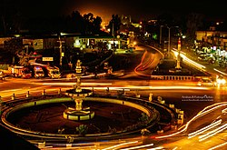
 Night view of Fawara Chowk, Hafizabad | |
| Coordinates: 32°04′17″N 73°41′16″E / 32.07139°N 73.68778°E | |
| Country | |
| Province | |
| Division | Gujrat |
| District | Hafizabad |
| Union councils | 25 |
| Government | |
| • Type | Municipal Committee |
| • Administrator | Umer Farooq[1] |
| Area | |
• Total | 38.5 km2 (14.9 sq mi) |
| Elevation | 208 m (682 ft) |
| Population (2017) | |
• Total | 245,751 |
| • Rank | 31st, Pakistan |
| • Density | 6,400/km2 (17,000/sq mi) |
| Language | |
| • Official | Urdu, Punjabi |
| Time zone | UTC+5 (PST) |
| Postal code | 52110 |
| Calling code | 0547 |
| Website | Municipal Committee Hafizabad |
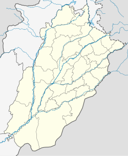
Hafizabad (Template:Lang-ur) is a city and capital of Hafizabad District located in Punjab, Pakistan.[2] It is located to the east of Chenab River. As of 2017, its total population is 245,751.[3]
History
In 327 BC, the area around Hafizabad was reportedly well-populated during Alexander's invasion of Punjab.[4] During the Delhi Sultanate period, majority of the local population were converted to Islam. A large city was situated at the site of the present village of Mehdiabad, northwest of present day Hafizabad. Later it became unpopulated due to shortage of water and Afghan incursions. The region remained uninhabited until the reign of Mughal emperor Akbar, when it became the site of a Mahal as documented in Ain-i-Akbari.[5]
After the Partition of India in 1947, the minority Hindus and Sikhs migrated to India while Muslim refugees from India settled in Hafizabad. Most of the refugees have since settled and inter-married with the local population.[citation needed]
Geography
Hafizabad is located 48 kilometres west of Gujranwala, and 60 kilometres southwest of Wazirabad. It hosts the eighth railway station on the Wazirabad-Faisalabad Railway.[6] Its average elevation is 208 metres above the sea level.[7]
Climate
Hafizabad has a hot semi-arid climate (Köppen BSh). The monsoon season is from July to September. It sees the most precipitation in July, with an average rainfall of 138.1 millimetres or 5.44 inches; and the least precipitation in November, with an average rainfall of 5.5 millimetres or 0.22 inches.
| Climate data for Hafizabad | |||||||||||||
|---|---|---|---|---|---|---|---|---|---|---|---|---|---|
| Month | Jan | Feb | Mar | Apr | May | Jun | Jul | Aug | Sep | Oct | Nov | Dec | Year |
| Mean daily maximum °C (°F) | 19 (66) |
22 (72) |
27 (81) |
33 (91) |
39 (102) |
40 (104) |
36 (97) |
35 (95) |
34 (93) |
31 (88) |
26 (79) |
21 (70) |
30 (87) |
| Daily mean °C (°F) | 12 (54) |
15 (59) |
20 (68) |
27 (81) |
32 (90) |
34 (93) |
32 (90) |
31 (88) |
29 (84) |
25 (77) |
18 (64) |
13 (55) |
24 (75) |
| Mean daily minimum °C (°F) | 6 (43) |
9 (48) |
14 (57) |
20 (68) |
25 (77) |
27 (81) |
28 (82) |
27 (81) |
24 (75) |
18 (64) |
11 (52) |
7 (45) |
18 (64) |
| Average rainfall mm (inches) | 18.1 (0.71) |
30.5 (1.20) |
32.8 (1.29) |
25.5 (1.00) |
17.0 (0.67) |
46.2 (1.82) |
138.1 (5.44) |
121.0 (4.76) |
51.7 (2.04) |
11.6 (0.46) |
5.5 (0.22) |
11.6 (0.46) |
509.6 (20.07) |
| Average rainy days (≥ 1 mm) | 3.1 | 3.6 | 4.7 | 4.0 | 3.7 | 7.2 | 14.5 | 13.6 | 6.7 | 2.4 | 0.9 | 2.0 | 66.4 |
| Mean daily daylight hours | 10.3 | 11.1 | 12.0 | 13.0 | 13.8 | 14.2 | 14.0 | 13.3 | 12.3 | 11.4 | 10.5 | 10.1 | 12.2 |
| Source: Weatherspark.com[8] | |||||||||||||
References
- ^ "Our Administrator / Chairman - Hafizabad". 2 August 2022. Retrieved 26 April 2023.
- ^ "Hafizabad | Punjab Portal".
- ^ "Punjāb (Pakistan): Province, Major Cities, Municipalites & Towns - Population Statistics, Maps, Charts, Weather and Web Information". www.citypopulation.de. Retrieved 27 April 2023.
- ^ "Hafizabad: History". Government of the Punjab. Archived from the original on 5 July 2014. Retrieved 5 March 2014.
- ^ "Imperial Gazetteer2 of India, Volume 13, page 5 – Imperial Gazetteer of India – Digital South Asia Library". dsal.uchicago.edu.
- ^ "Our History | Hafizabad". hafizabad.punjab.gov.pk. Retrieved 27 April 2023.
- ^ "Hafizabad topographic map, elevation, terrain". Topographic maps. Retrieved 27 April 2023.
- ^ "Climate and Average Weather Year Round in Hāfizābād, Pakistan". weatherspark.com. Retrieved 26 April 2023.


