Komańcza: Difference between revisions
c |
No edit summary |
||
| Line 8: | Line 8: | ||
image_seal =| |
image_seal =| |
||
subdivision_type1 =Region | |
subdivision_type1 =Region | |
||
region_type_local = | |
region_type_local = [[Bieszczady Mountains]]| |
||
subdivision_name1 =Subcarpathian Voivodship | |
subdivision_name1 =Subcarpathian Voivodship | |
||
region_link =| |
region_link =| |
||
Revision as of 10:02, 2 April 2007
49°21′N 22°04′E / 49.350°N 22.067°E
Komańcza
Komańcza | |
|---|---|
Village | |
 | |
| Country | Poland |
| Region | Subcarpathian Voivodship |
| Founded | 1512 |
| Population | |
• Total | 880 |
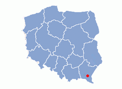
Komańcza is a village in the Sanok County in the East Małopolska in the Lesser Beskid mountains, located near the towns of Medzilaborce and Palota (in northeastern Slovakia). Latin parish in loco.
History
Komanycza, Crziemyenna – 1512, de Komancza – 1524. In historical records the village was first mentioned in 1512. The church was "Patronage of the Blessed Virgin Mary" buit in 1805, still standing. The wooden church was renovated in 1919. After WWII the church was still in use until 1962, when it was taken by the Orthodox. Services were then held in a Roman Catholic chapel until 1987 when a Ukrainian Catholic church was built. Filial churches located in Czystohorb (3 km away), and Dołżyca (4 km). The priest was killed by the UPA here in 1944. The wooden church is protected as an architectural landmark by the Polish government. The church houses a number of ancient liturgical books dated 1638 to 1793. The village was burned down 1946 by the UPA. In 1785 the village lands comprised 8.94 km². There were c. 470 Catholics and 15 Jews.
Geography
The municipality lies at an elevation of 482 metres and covers an area of 8.3 km². It has a population of about 880.
Time zone :
UTC+1/SummerUTC+2
External links
