Erg Chebbi: Difference between revisions
No edit summary Tag: Reverted |
Restored revision 1187680932 by 38.32.141.250 (talk): Restoring older version |
||
| Line 81: | Line 81: | ||
}} |
}} |
||
[[File:Erg Chebbi pano.jpg|thumb|right|280px|Panorama showing the transition of flat desert to dunes]] |
[[File:Erg Chebbi pano.jpg|thumb|right|280px|Panorama showing the transition of flat desert to dunes]] |
||
'''Erg Chebbi''' ({{lang-ar|عرق الشبي}}; {{lang-ber|ⴻⵔⴳ ⵛⴱⵉ}}) is one of [[Morocco]]'s several [[erg (landform)|ergs]] – large seas of dunes formed by wind-blown sand. <ref>https:// |
'''Erg Chebbi''' ({{lang-ar|عرق الشبي}}; {{lang-ber|ⴻⵔⴳ ⵛⴱⵉ}}) is one of [[Morocco]]'s several [[erg (landform)|ergs]] – large seas of dunes formed by wind-blown sand. It is located on the far western edge of the [[Sahara]] Desert.<ref>https://www.britannica.com/place/Sahara-desert-Africa/Climate#/media/1/516375/61717</ref> There are several other ergs in Morocco, such as [[Erg Chigaga]] near [[M'Hamid El Ghizlane|M'hamid]]. |
||
This area is not part of the Sahara desert , which is still a few hundred kilometers on the other side of the Algerian border. It is still very spectacular. Very well worth a visit. |
|||
see the map |
|||
https://eztouregypt.com/wp-content/uploads/2023/02/Downloader_la_-63f108321e1b2-transformed.jpeg |
|||
==Description== |
==Description== |
||
In places, the dunes of Erg Chebbi rise to 150 meters from the surrounding [[hamada]] (rocky desert) and altogether span an area of approximately 28 kilometers from north to south and 5–7 kilometers from east to west lining the [[Algeria]]n border.<ref>[http://www.roughguides.com/destinations/africa/morocco/southern-oases-routes/ziz-tafilalt/merzouga-erg-chebbi/ Merzouga and the Erg Chebbi – Rough Guides]</ref> |
In places, the dunes of Erg Chebbi rise to 150 meters from the surrounding [[hamada]] (rocky desert) and altogether span an area of approximately 28 kilometers from north to south and 5–7 kilometers from east to west lining the [[Algeria]]n border.<ref>[http://www.roughguides.com/destinations/africa/morocco/southern-oases-routes/ziz-tafilalt/merzouga-erg-chebbi/ Merzouga and the Erg Chebbi – Rough Guides]</ref> |
||
The nearest sizable town is [[Erfoud]], about 60 kilometers further north. One other city is [[Rissani]], around 40 kilometers from [[Merzouga]]. Rissani was the site of a kingdom known as Sijilmassa, which became prosperous from the 8th to the 14th century due to its control of the caravan routes. |
The nearest sizable town is [[Erfoud]], about 60 kilometers further north. One other city is [[Rissani]], around 40 kilometers from [[Merzouga]]. Rissani was the site of a kingdom known as Sijilmassa, which became prosperous from the 8th to the 14th century due to its control of the caravan routes. |
||
| Line 97: | Line 91: | ||
==Tourism== |
==Tourism== |
||
[[Merzouga]], the local tourist center, is located on the western lee of the dunes, together with hotels and auberges running |
[[Merzouga]], the local tourist center, is located on the western lee of the dunes, together with hotels and auberges running north-south along the dunes. Many companies offer camel trips into the dunes, taking tourists on overnight trips to permanent campsites on the outer sections of the erg. Erg Chebbi's proximity to the tourist center has led to the erg sometimes being referred to as the "dunes of Merzouga".<ref>{{cite book|last1=Jean Michel|first1=Jarre|title=Jean Michel Jarre - The Making of Water for Life|date=2007|publisher=Idesine|isbn=9781903527238|page=31}}</ref> |
||
During the warmest part of the year, some Moroccans come to Erg Chebbi to be buried neck-deep in the hot sand for a few minutes at a time. This is considered to be a treatment for [[rheumatism]]. |
During the warmest part of the year, some Moroccans come to Erg Chebbi to be buried neck-deep in the hot sand for a few minutes at a time. This is considered to be a treatment for [[rheumatism]]. |
||
Revision as of 17:17, 23 February 2024
Erg Chebbi
عرق الشبي ⴻⵔⴳ ⵛⴱⵉ | |
|---|---|
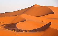
 Landscape of the Erg Chebbi at sunset | |
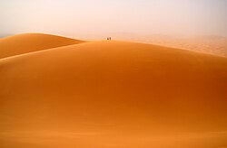
 Two people atop one of the main dunes | |
| Coordinates: 31°10′N 03°59′W / 31.167°N 3.983°W | |
| Country | Morocco |
| Elevation | 730 m (2,400 ft) |

Erg Chebbi (Template:Lang-ar; Template:Lang-ber) is one of Morocco's several ergs – large seas of dunes formed by wind-blown sand. It is located on the far western edge of the Sahara Desert.[1] There are several other ergs in Morocco, such as Erg Chigaga near M'hamid.
Description
In places, the dunes of Erg Chebbi rise to 150 meters from the surrounding hamada (rocky desert) and altogether span an area of approximately 28 kilometers from north to south and 5–7 kilometers from east to west lining the Algerian border.[2]
The nearest sizable town is Erfoud, about 60 kilometers further north. One other city is Rissani, around 40 kilometers from Merzouga. Rissani was the site of a kingdom known as Sijilmassa, which became prosperous from the 8th to the 14th century due to its control of the caravan routes.
Although rainfall is not very common, in 2006 flooding adjacent to the dunes destroyed many buildings and killed three people.
Tourism
Merzouga, the local tourist center, is located on the western lee of the dunes, together with hotels and auberges running north-south along the dunes. Many companies offer camel trips into the dunes, taking tourists on overnight trips to permanent campsites on the outer sections of the erg. Erg Chebbi's proximity to the tourist center has led to the erg sometimes being referred to as the "dunes of Merzouga".[3]
During the warmest part of the year, some Moroccans come to Erg Chebbi to be buried neck-deep in the hot sand for a few minutes at a time. This is considered to be a treatment for rheumatism.
Features

-
the Erg Chebbi seen from the outskirts of Merzouga
-
Camels used for tours into the erg
See also

References
- ^ https://www.britannica.com/place/Sahara-desert-Africa/Climate#/media/1/516375/61717
- ^ Merzouga and the Erg Chebbi – Rough Guides
- ^ Jean Michel, Jarre (2007). Jean Michel Jarre - The Making of Water for Life. Idesine. p. 31. ISBN 9781903527238.


