Suchitepéquez Department: Difference between revisions
Appearance
Content deleted Content added
No edit summary |
No edit summary |
||
| Line 89: | Line 89: | ||
| population_blank1 = |
| population_blank1 = |
||
| population_blank2_title = Religions |
| population_blank2_title = Religions |
||
| population_blank2 = [[Roman Catholicism]], [[Evangelicalism]], [[ |
| population_blank2 = [[Roman Catholicism]], [[Evangelicalism]], [[Christian religion]] |
||
| population_density_blank1_km2 = |
| population_density_blank1_km2 = |
||
| population_density_blank1_sq_mi = <!-- General information ---------------> |
| population_density_blank1_sq_mi = <!-- General information ---------------> |
||
Revision as of 19:12, 3 April 2024
You can help expand this article with text translated from the corresponding article in Spanish. (January 2023) Click [show] for important translation instructions.
|
Suchitepéquez Department
Departmento de Suchitepéquez | |
|---|---|
 Arenal Volcano | |
 Suchitepéquez | |
| Country | |
| Capital | Mazatenango |
| Municipalities | 20 |
| Government | |
| • Type | Departmental |
| Area | |
| 2,510 km2 (970 sq mi) | |
| Population (2018)[1] | |
| 554,695 | |
| • Density | 220/km2 (570/sq mi) |
| • Urban | 266,189 |
| • Religions | Roman Catholicism Evangelicalism Christian religion |
| Time zone | UTC-6 |
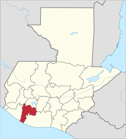
Suchitepéquez (Template:IPA-es) is one of the 22 departments of Guatemala. Its capital is Mazatenango. It is situated in the southwestern region of Guatemala, bordering Quetzaltenango, Sololá, and Chimaltenango to the north, the Pacific Ocean to the south, Escuintla to the east, and Retalhuleu to the west.
Municipalities
- Chicacao
- Cuyotenango
- Mazatenango
- Patulul
- Pueblo Nuevo
- Río Bravo
- Samayac
- San Antonio Suchitepéquez
- San Bernardino
- San Francisco Zapotitlán
- San Gabriel
- San José El Idolo
- San Juan Bautista
- San Lorenzo, Suchitepéquez
- San Miguel Panán
- San Pablo Jocopilas
- Santa Bárbara
- Santo Domingo Suchitepequez
- Santo Tomás La Unión
- Zunilito
References
- ^ Citypopulation.de Population of departments in Guatemala
Gall, Francis (1976). Diccionario Geográfico de Guatemala. 4 vols. Guatemala: Instituto Geográfico Nacional.
External links
14°32′02″N 91°30′11″W / 14.534°N 91.503°W


