University, Minneapolis: Difference between revisions
Appearance
Content deleted Content added
added distinguishing mark for the university of Minnesota - Twin Cities (the namesake of the community/located within) |
I can't see anything saying that Mid-City Industrial isn't a neighborhood -- it seems to be considered a neighborhood in recent communications by the city (ref added) |
||
| Line 68: | Line 68: | ||
|2020= 51922 |
|2020= 51922 |
||
}} |
}} |
||
'''University''' is a community in [[Minneapolis]]. It is composed of six smaller neighborhoods. It also contains the [[University of Minnesota]] campus |
'''University''' is a community in [[Minneapolis]]. It is composed of six smaller neighborhoods. It also contains the [[University of Minnesota]] campus. Most of the community is commonly referred to as '''Southeast Minneapolis''' due street names with a SE suffix.<ref>{{cite news |last1=Galioto |first1=Katie |title=Why is southeast Minneapolis located northeast of downtown? |url=https://www.startribune.com/why-is-southeast-minneapolis-located-northeast-of-downtown/511630951/ |access-date=17 April 2024 |work=Star Tribune |date=July 13, 2019}}</ref> |
||
==Official neighborhoods in the University community== |
==Official neighborhoods in the University community== |
||
| Line 77: | Line 77: | ||
*[[Prospect Park, Minneapolis|Prospect Park]] |
*[[Prospect Park, Minneapolis|Prospect Park]] |
||
*[[University (neighborhood), Minneapolis|University]] |
*[[University (neighborhood), Minneapolis|University]] |
||
*[[Mid-City Industrial, Minneapolis|Mid-City Industrial]]<ref>{{cite web |title=Mid-City Industrial reconstruction |url=https://www2.minneapolismn.gov/government/projects/public-works/completed-projects/complete-cip/mid-city-industrial/ |website=City of Minneapolis |access-date=17 April 2024}}</ref> |
|||
==References== |
==References== |
||
Revision as of 19:34, 17 April 2024
University | |
|---|---|
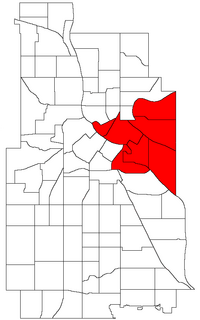
 Location of University within the U.S. city of Minneapolis | |
| Coordinates: 44°59′0″N 93°14′0″W / 44.98333°N 93.23333°W | |
| Country | United States |
| State | Minnesota |
| County | Hennepin |
| City | Minneapolis |
| Neighborhoods | |
| Area | |
• Total | 5.714 sq mi (14.80 km2) |
| Population (2020)[2] | |
• Total | 51,922 |
| • Density | 9,100/sq mi (3,500/km2) |
| Time zone | UTC-6 (CST) |
| • Summer (DST) | UTC-5 (CDT) |
| ZIP code | 55401, 55413, 55414, 55454, 55455 |
| Area code | 612 |
| Census | Pop. | Note | %± |
|---|---|---|---|
| 1980 | 29,818 | — | |
| 1990 | 30,464 | 2.2% | |
| 2000 | 33,440 | 9.8% | |
| 2010 | 38,785 | 16.0% | |
| 2020 | 51,922 | 33.9% |
University is a community in Minneapolis. It is composed of six smaller neighborhoods. It also contains the University of Minnesota campus. Most of the community is commonly referred to as Southeast Minneapolis due street names with a SE suffix.[3]
Official neighborhoods in the University community
- Cedar-Riverside, also known as the West Bank
- Como
- Marcy-Holmes part of this neighborhood contains an area more commonly known as Dinkytown.
- Nicollet Island/East Bank
- Prospect Park
- University
- Mid-City Industrial[4]
References
- ^ "University neighborhood in Minneapolis, Minnesota (MN), 55413, 55414, 55454, 55455 detailed profile". City-Data. 2011. Retrieved 2013-11-12.
- ^ "University community data". Minnesota Compass. Retrieved 2023-04-02.
- ^ Galioto, Katie (July 13, 2019). "Why is southeast Minneapolis located northeast of downtown?". Star Tribune. Retrieved 17 April 2024.
- ^ "Mid-City Industrial reconstruction". City of Minneapolis. Retrieved 17 April 2024.
