Santa Fé de Goiás: Difference between revisions
Appearance
Content deleted Content added
m →Political Information: Genfixes |
Phrasing |
||
| Line 51: | Line 51: | ||
| website = |
| website = |
||
}} |
}} |
||
'''Santa Fé de Goiás''' is a [[Municipalities of Brazil|municipality]] in west-central [[ |
'''Santa Fé de Goiás''' is a [[Municipalities of Brazil|municipality]] in the west-central [[Brazil|Brazilian]] state of [[Goiás]]. |
||
==Location== |
==Location== |
||
Latest revision as of 18:05, 31 May 2024
Santa Fé de Goiás | |
|---|---|
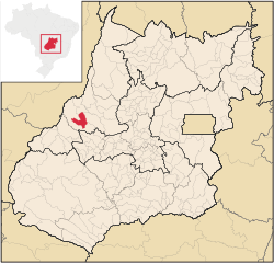
 Location in Goiás state | |
| Coordinates: 15°46′12″S 51°05′45″W / 15.77000°S 51.09583°W | |
| Country | Brazil |
| Region | Central-West |
| State | Goiás |
| Microregion | Rio Vermelho Microregion |
| Area | |
• Total | 1,160.8 km2 (448.2 sq mi) |
| Elevation | 362 m (1,188 ft) |
| Population (2010 [1]) | |
• Total | 4,762 |
| • Density | 4.1/km2 (11/sq mi) |
| Time zone | UTC−3 (BRT) |
| Postal code | 76265-000 |
Santa Fé de Goiás is a municipality in the west-central Brazilian state of Goiás.
Location
[edit]Santa Fé is located almost directly west of Brasília and northwest of Goiânia. The nearest town of any size is Jussara, which lies 34 km. to the southeast.
- Distance to regional center (Goiás Velho): 132 km.
- Highway connections: GO-060 / Trindade / GO-326 / Anicuns / Sanclerlândia / Novo Brasil / Jussara / BR-070 / Nova Trindade / GO-173.
Neighboring municipalities: Jussara, Britânia, Itapirapuã
Politics
[edit]- Mayor: Ademar Marques de Carvalho (January 2005)
- City council: 09
- Eligible voters: 3,885 (December 2007)
In 1957, Santa Fé de Goiás became a district belonging to Goiás. In 1958, it was dismembered to become a district in the municipality of Jussara. In 1988, it got its municipal autonomy.
Demographics
[edit]- Population density: 3.96 inhabitants/km2 (2007)
- Urban population: 3,514 (2007)
- Rural population: 1,080 (2007)
- Population growth: a gain of about 900 people since 1991
Economy
[edit]The economy is based on subsistence agriculture, cattle raising, services, public administration, and small transformation industries.
- Industrial units: 6 (2007)
- Commercial units: 57 (2007)
- Meat-packing plant: Frigorífico Arantes Ltda
- Cattle herd: 135,000 head
- Main crops: cotton, rice, sugarcane, bananas, sesame seeds, corn, and soybeans.
- Motor vehicles: 231 automobiles, 34 trucks, and 37 pickup trucks (2007)
Education (2006)
[edit]- Schools: 5
- Classrooms: 30
- Teachers: 60
- Students: 1,314
- Higher education: none
- Adult literacy rate: 83.7% (2000) (national average was 86.4%)
Health (2003)
[edit]- Hospitals: 0
- Hospital beds: 0
- Ambulatory clinics: 2
- Doctors, nurses, dentists: 3, 1, 1 (2002)
- Infant mortality rate: 26.34 (2000) (national average was 33.0)
- MHDI: 0.713
- State ranking: 190 (out of 242 municipalities)
- National ranking: 2,744 (out of 5,507 municipalities)


