Skakavac (Sarajevo): Difference between revisions
m Replacing equivalent expression in cvt/convert templates to avoid erroneous replacement (via WP:JWB) |
|||
| Line 77: | Line 77: | ||
==Gallery== |
==Gallery== |
||
<gallery mode=packed> |
<gallery mode="packed"> |
||
File:Vodopad Skakavac u Sarajeva, od paty.jpg|Waterfall |
|||
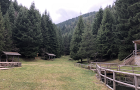
File:Rest area Skakavac.png|alt=Shelters and evergreen trees|Rest area above the waterfall |
File:Rest area Skakavac.png|alt=Shelters and evergreen trees|Rest area above the waterfall |
||
File:Bears paws on the trail to Motka.png|alt=Bear pawprints in soft ground|Bear pawprints on the trail to Motka |
File:Bears paws on the trail to Motka.png|alt=Bear pawprints in soft ground|Bear pawprints on the trail to Motka |
||
File:Trail up from Skakavac Waterfall.png|alt=Steep trail with steps and handrails|Trail from the waterfall |
File:Trail up from Skakavac Waterfall.png|alt=Steep trail with steps and handrails|Trail from the waterfall |
||
File:View down from the waterfall.png|alt=Trees and mountains in autumn|View from the waterfall |
File:View down from the waterfall.png|alt=Trees and mountains in autumn|View from the waterfall |
||
File: |
File:Entrance to Nature Preserve Skakavac.png|Entrance to Nature Preserve Skakavac |
||
</gallery> |
</gallery> |
||
Latest revision as of 22:32, 1 June 2024
This article needs additional citations for verification. (July 2020) |
| Skakavac | |||||||||||||||||||
|---|---|---|---|---|---|---|---|---|---|---|---|---|---|---|---|---|---|---|---|
 | |||||||||||||||||||
 | |||||||||||||||||||
| Location | Sarajevo Canton, Bosnia and Herzegovina | ||||||||||||||||||
| Coordinates | 43°56′55″N 18°26′56″E / 43.94861°N 18.44889°E | ||||||||||||||||||
| Elevation | 980 metres (3,220 ft) | ||||||||||||||||||
| Total height | 98 metres (322 ft) | ||||||||||||||||||
| Watercourse | Skakavac | ||||||||||||||||||
| |||||||||||||||||||
Skakavac (lit. "grasshopper") is a waterfall in Bosnia and Herzegovina. It is 12 kilometres (7.5 mi) northeast of Sarajevo, above the village of Nahorevo.[3] At 98 metres (322 ft), it is one of the tallest waterfalls in the Balkans[4] and traverses a vertical limestone face. The waterfall freezes in winter into a number of shapes.[5] Part of a stream of the same name, it flows below the peak of the 1,532-metre (5,026 ft) Bukovik into Perak Creek. Vegetation around the waterfall consists of endemic and relict plants. Nearby trails are frequented by mountain bikers and hikers. In 2002, the waterfall and its surroundings were declared a natural monument by the Sarajevo Canton government.[6]
Tourist attraction
[edit]The main tourist attraction of the park - Skakavac waterfall - can be reached by trail.[7] The trailhead is accessible by bus or car and by foot.[8] Visitors can travel to the waterfall trailhead from Nahorevo or hike from Sarajevo through Nahorevo and the Skakavac Nature Preserve.[7] The waterfall may also be reached by vehicle, with rest areas available along the trail.
Gallery
[edit]-
Waterfall
-
Rest area above the waterfall
-
Bear pawprints on the trail to Motka
-
Trail from the waterfall
-
View from the waterfall
-
Entrance to Nature Preserve Skakavac
See also
[edit]- Skakavac Waterfall, Perućica, another waterfall in Bosnia
References
[edit]- ^ Skakavac Waterfall -Vodopad Wikimapia
- ^ Skakavac Protected Planet
- ^ DestiMap.com. "Skakavac, Sarajevo Canton". DestiMap. Retrieved 2020-08-06.
- ^ "Chasing Famous Waterfalls in the Balkans | Balkans Travel Guide". Chasing the Donkey. 2017-03-07. Retrieved 2020-08-26.
- ^ "Skakavac". Sarajevo.travel. Retrieved 2020-08-26.
- ^ "Skakavac Waterfall". www.sarajevo-tourism.com. Retrieved 2020-08-26.
- ^ a b "Waterfall Skakavac". Feel Bosnia. Promo Tours. Retrieved 2020-08-06.
- ^ "Skakavac". www.outdooractive.com. Retrieved 2020-08-25.
- IUCN Category III
- Waterfalls of Bosnia and Herzegovina
- Landforms of the Federation of Bosnia and Herzegovina
- Tourist attractions in Bosnia and Herzegovina
- Sarajevo Canton
- Nature monuments of Bosnia and Herzegovina
- Protected areas of Bosnia and Herzegovina
- Protected areas established in 2002
- Sarajevo Canton geography stubs


