Jabkenice: Difference between revisions
m →Sights |
population |
||
| Line 36: | Line 36: | ||
| elevation_m = 230 |
| elevation_m = 230 |
||
<!-- population --> |
<!-- population --> |
||
| population_as_of = |
| population_as_of = 2024-01-01 |
||
| population_footnotes = <ref>{{cite web |title=Population of Municipalities – 1 January |
| population_footnotes = <ref>{{cite web |title=Population of Municipalities – 1 January 2024|url=https://www.czso.cz/csu/czso/population-of-municipalities-qexb0dqr2d|publisher=[[Czech Statistical Office]]|date=2024-05-17}}</ref> |
||
| population_total = |
| population_total = 488 |
||
| population_density_km2 = auto |
| population_density_km2 = auto |
||
<!-- time zone(s) --> |
<!-- time zone(s) --> |
||
| Line 57: | Line 57: | ||
==Etymology== |
==Etymology== |
||
The name was probably derived from the Czech words ''jablko'' ( |
The name was probably derived from the Czech words ''jablko'' ('apple') and ''jabloň'' ('apple tree').<ref name=history>{{cite web |title=Naše obec|url=http://www.jabkenice.cz/oficialni-stranky-obce-jabkenice|publisher=Obec Jabkenice|language=cs|access-date=2023-03-14}}</ref> |
||
==Geography== |
==Geography== |
||
Revision as of 10:15, 5 June 2024
Jabkenice | |
|---|---|
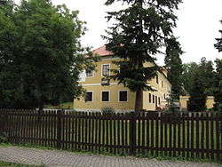
 Memorial of Bedřich Smetana | |
| Coordinates: 50°19′27″N 15°0′53″E / 50.32417°N 15.01472°E | |
| Country | |
| Region | Central Bohemian |
| District | Mladá Boleslav |
| First mentioned | 1352 |
| Area | |
• Total | 11.86 km2 (4.58 sq mi) |
| Elevation | 230 m (750 ft) |
| Population (2024-01-01)[1] | |
• Total | 488 |
| • Density | 41/km2 (110/sq mi) |
| Time zone | UTC+1 (CET) |
| • Summer (DST) | UTC+2 (CEST) |
| Postal code | 294 45 |
| Website | www |
Jabkenice is a municipality and village in Mladá Boleslav District in the Central Bohemian Region of the Czech Republic. It has about 500 inhabitants.
Etymology
The name was probably derived from the Czech words jablko ('apple') and jabloň ('apple tree').[2]
Geography
Jabkenice is located about 12 kilometres (7 mi) south of Mladá Boleslav and 41 km (25 mi) northeast of Prague. It lies in a flat landscape in the Jizera Table. The brook Jabkenický potok flows through the municipality and supplies a system of fishponds.
History
The first written mention of Jabkenice is from 1352. From 1924 to 1950, it was called Jablkynice.[2]
Demographics
|
|
| ||||||||||||||||||||||||||||||||||||||||||||||||||||||
| Source: Censuses[3][4] | ||||||||||||||||||||||||||||||||||||||||||||||||||||||||
Transport
There are no railways or major roads passing through the municipality.
Sights
The main landmark of Jabkenice is the Church of the Nativity of the Virgin Mary. It is a Gothic cemetery church from the 13th century. Next to the church is a separate wooden bell tower.[5]
Jabkenice Lodge next to a large game park was built for the Thurn und Taxis family as the seat of the forestry office. The building became known as the last residence of Bedřich Smetana, who wrote some of his most famous works here. Today, the Bedřich Smetana Memorial with a museum about his life and work is located here.[6]
Notable people
- Bedřich Smetana (1824–1884), composer; lived and worked here in 1875–1884
References
- ^ "Population of Municipalities – 1 January 2024". Czech Statistical Office. 2024-05-17.
- ^ a b "Naše obec" (in Czech). Obec Jabkenice. Retrieved 2023-03-14.
- ^ "Historický lexikon obcí České republiky 1869–2011 – Okres Mladá Boleslav" (in Czech). Czech Statistical Office. 2015-12-21. pp. 7–8.
- ^ "Population Census 2021: Population by sex". Public Database. Czech Statistical Office. 2021-03-27.
- ^ "Kostel Narození Panny Marie" (in Czech). National Heritage Institute. Retrieved 2023-03-14.
- ^ "Bedřich Smetana Memorial". National Museum. Retrieved 2023-03-14.
External links


