Lehavim: Difference between revisions
Filled in 1 bare reference(s) with reFill 2 |
ce |
||
| Line 33: | Line 33: | ||
[[File:Lehavim Synagogue.jpeg|thumb|200px|Lehavim [[synagogue]]|left]] |
[[File:Lehavim Synagogue.jpeg|thumb|200px|Lehavim [[synagogue]]|left]] |
||
Lehavim, originally called "Givat Lahav,"<ref name="muni"/> covers an area of 2,525 [[dunam]]s (2.5 km<sup>2</sup>). It is one of [[Beersheba]]'s three satellite towns (the others are [[Omer, Israel|Omer]] and [[Meitar]]). Most of the inhabitants commute to Beersheba for work. Lehavim is an upper-middle class community of detached homes surrounded by palm trees and gardens. As of 2017, it received the highest ranking on the Israeli Socio-Economic Index (10 out of 10)<ref>[https://www.cbs.gov.il/he/publications/doclib/2021/socio_eco17_1832/t01.pdf Socio Economy] cbs.gov.il {{dead link|date=December 2023}}</ref> according to the [[Israel Central Bureau of Statistics]] along with only three other municipalities ([[Omer, Israel|Omer]], [[Kfar Shmaryahu]] and [[Savyon]]). The town has a library, a country club, kindergartens, a school, two synagogues, and a commercial center. Lehavim achieved a municipal status in 1988.<ref name="muni">{{Cite web|url=http://www.lehavim.muni.il/About/|archiveurl=https://web.archive.org/web/20080415032302/http://www.lehavim.muni.il/About/|url-status=dead|title=מועצה מקומית להבים | Lehavim Local Council - About|archivedate=15 April 2008}}</ref> |
Lehavim, originally called "Givat Lahav,"<ref name="muni"/> covers an area of 2,525 [[dunam]]s (2.5 km<sup>2</sup>). It is one of [[Beersheba]]'s three satellite towns (the others are [[Omer, Israel|Omer]] and [[Meitar]]). Most of the inhabitants commute to Beersheba for work. Lehavim is an upper-middle class community of detached homes surrounded by palm trees and gardens. As of 2017, it received the highest ranking on the Israeli Socio-Economic Index (10 out of 10)<ref>[https://www.cbs.gov.il/he/publications/doclib/2021/socio_eco17_1832/t01.pdf Socio Economy] cbs.gov.il {{dead link|date=December 2023}}</ref> according to the [[Israel Central Bureau of Statistics]] along with only three other municipalities ([[Omer, Israel|Omer]], [[Kfar Shmaryahu]] and [[Savyon]]). The town has a library, a country club, kindergartens, a school, two synagogues, and a commercial center. Lehavim achieved a municipal status in 1988.<ref name="muni">{{Cite web|url=http://www.lehavim.muni.il/About/|archiveurl=https://web.archive.org/web/20080415032302/http://www.lehavim.muni.il/About/|url-status=dead|title=מועצה מקומית להבים | Lehavim Local Council - About|archivedate=15 April 2008}}</ref> |
||
| ⚫ | |||
==Transportation== |
==Transportation== |
||
| ⚫ | |||
Lehavim is located near the intersection of [[Highway 40 (Israel)|Highway 40]] ([[Beersheba]]–[[Tel Aviv]]) and [[Highway 31 (Israel)|Highway 31]] ([[Arad, Israel|Arad]]–[[Rahat]]), known as the Lehavim Junction. The [[Railway to Beersheba|Lod–Beersheba railway line]] passes through this crossing. The [[Lehavim Railway Station]], inaugurated in 2007 on the western side of Lehavim, and its proximity to [[Highway 6 (Israel)|Highway 6]], have served as an economic catalyst.<ref>[http://www.haaretz.com/print-edition/business/red-hot-times-in-the-desert-1.6666 Red-hot times in the desert], [[Haaretz]]</ref> |
Lehavim is located near the intersection of [[Highway 40 (Israel)|Highway 40]] ([[Beersheba]]–[[Tel Aviv]]) and [[Highway 31 (Israel)|Highway 31]] ([[Arad, Israel|Arad]]–[[Rahat]]), known as the Lehavim Junction. The [[Railway to Beersheba|Lod–Beersheba railway line]] passes through this crossing. The [[Lehavim Railway Station]], inaugurated in 2007 on the western side of Lehavim, and its proximity to [[Highway 6 (Israel)|Highway 6]], have served as an economic catalyst.<ref>[http://www.haaretz.com/print-edition/business/red-hot-times-in-the-desert-1.6666 Red-hot times in the desert], [[Haaretz]]</ref> |
||
Revision as of 19:16, 15 June 2024
Lehavim
לְהָבִים | |
|---|---|
 | |
| Coordinates: 31°22′08″N 34°48′47″E / 31.36889°N 34.81306°E | |
| District | Southern |
| Founded | 1983 |
| Government | |
| • Head of Municipality | Elad Arazi |
| Area | |
• Total | 2,525 dunams (2.525 km2 or 624 acres) |
| Population (2022)[1] | |
• Total | 7,219 |
| • Density | 2,900/km2 (7,400/sq mi) |
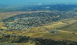
Lehavim (Template:Lang-he) is an affluent town in southern Israel. Founded in 1983 and located in the northern Negev around 15 km north of Beersheba, it is a local council. In 2022 it had a population of 7,219.[1]
History

Lehavim, originally called "Givat Lahav,"[2] covers an area of 2,525 dunams (2.5 km2). It is one of Beersheba's three satellite towns (the others are Omer and Meitar). Most of the inhabitants commute to Beersheba for work. Lehavim is an upper-middle class community of detached homes surrounded by palm trees and gardens. As of 2017, it received the highest ranking on the Israeli Socio-Economic Index (10 out of 10)[3] according to the Israel Central Bureau of Statistics along with only three other municipalities (Omer, Kfar Shmaryahu and Savyon). The town has a library, a country club, kindergartens, a school, two synagogues, and a commercial center. Lehavim achieved a municipal status in 1988.[2]
Transportation
Lehavim is located near the intersection of Highway 40 (Beersheba–Tel Aviv) and Highway 31 (Arad–Rahat), known as the Lehavim Junction. The Lod–Beersheba railway line passes through this crossing. The Lehavim Railway Station, inaugurated in 2007 on the western side of Lehavim, and its proximity to Highway 6, have served as an economic catalyst.[4]
Notable residents
- Ron Darmon (born 1992), Olympic triathlete[5]
References
- ^ a b "Regional Statistics". Israel Central Bureau of Statistics. Retrieved 21 March 2024.
- ^ a b "מועצה מקומית להבים | Lehavim Local Council - About". Archived from the original on 15 April 2008.
- ^ Socio Economy cbs.gov.il [dead link]
- ^ Red-hot times in the desert, Haaretz
- ^ "Israel to Debut First Olympic Triathlete | IFCJ". web.archive.org. 17 September 2016.


