Arkhangai Province: Difference between revisions
sourced content. |
there is another page for Otuken https://en.wikipedia.org/wiki/Otuken here is the page only about Arkhangai province |
||
| Line 76: | Line 76: | ||
'''Arkhangai Province''' ({{lang-mn|Архангай аймаг}}, {{IPA-mn|arχəɴˈɢæˑ ˈæˑməq|pron}}) is one of the 21 [[aimags of Mongolia]]. It is located slightly west of the country's center, on the northern slopes of the [[Khangai Mountains]]. It is composed of 19 sums. |
'''Arkhangai Province''' ({{lang-mn|Архангай аймаг}}, {{IPA-mn|arχəɴˈɢæˑ ˈæˑməq|pron}}) is one of the 21 [[aimags of Mongolia]]. It is located slightly west of the country's center, on the northern slopes of the [[Khangai Mountains]]. It is composed of 19 sums. |
||
It includes the present-day borders of [[Otuken]], the sacred capital of the [[Turkic peoples]] in [[Central Asia]] and considered sacred by the [[Mongols]].<ref>{{cite web | url=https://www.trtavaz.com.tr/haber/tur/avrasyadan/turklerin-tarihi-baskenti-otuken/617b88b501a30a10a4e18f84# | title=Türklerin tarihî başkenti: Ötüken - Avrasya'dan - Haber }}</ref> |
|||
== Climate == |
== Climate == |
||
In winter mean temperature is −30 °C to −38 °C (−22 °F to −36 °F) and in summer the highest temperature is between 25 °C and 36 °C (77 °F and 97 °F). |
In winter mean temperature is −30 °C to −38 °C (−22 °F to −36 °F) and in summer the highest temperature is between 25 °C and 36 °C (77 °F and 97 °F). |
||
Revision as of 17:41, 5 July 2024
Arkhangai Province
Архангай аймаг ᠠᠷᠤᠬᠠᠩᠭ᠋ᠠᠢᠠᠶᠢᠮᠠᠭ | |
|---|---|
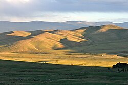
 Arkhangai in 2013 | |
 | |
| Coordinates: 47°23′N 101°30′E / 47.383°N 101.500°E | |
| Country | Mongolia |
| Established | 1931 |
| Capital | Tsetserleg |
| Area | |
• Total | 55,313.82 km2 (21,356.79 sq mi) |
| Elevation (average)[2] | 2,414 m (7,920 ft) |
| Population (2022) | |
• Total | 95,253[1] |
| GDP | |
| • Total | MNT 864 billion US$ 0.3 billion (2022) |
| • Per capita | MNT 9,042,820 US$ 2,895 (2022) |
| Time zone | UTC+8 |
| Area code | +976 133 |
| ISO 3166 code | MN-073 |
| Vehicle registration | АР_ |
| Website | arkhangai |

Arkhangai Province (Template:Lang-mn, pronounced [arχəɴˈɢæˑ ˈæˑməq]) is one of the 21 aimags of Mongolia. It is located slightly west of the country's center, on the northern slopes of the Khangai Mountains. It is composed of 19 sums.
Climate
In winter mean temperature is −30 °C to −38 °C (−22 °F to −36 °F) and in summer the highest temperature is between 25 °C and 36 °C (77 °F and 97 °F).
Economy
The main field of economy in the aimag is agriculture, predominantly animal husbandry. According to 2004 data, the aimag was home to 1,948,000 domestic animals: goats, sheep, cattle (incl. yaks and khainags), horses and camels. Camels are almost exclusively herded in the southeastern sums.[4]
Administrative subdivisions

Arkhangai province has 19 sums and 101 bags.[5] The aimag capital Tsetserleg is geographically located in the Erdenebulgan sum in the south of the aimag. It is not to be confused with the Tsetserleg sum in the north.
| Sum | Mongolian | Population (2005)[6] |
Population (2008)[7] |
Population (2009)[6] |
Area km² |
Density /km² |
Sum centre population |
|---|---|---|---|---|---|---|---|
| Battsengel | Батцэнгэл | 3,818 | 3,855 | 3,846 | 3,500 | 1.10 | 1,096 |
| Bulgan | Булган | 2,285 | 2,361 | 2,434 | 3,100 | 0.79 | 961 |
| Chuluut | Чулуут | 3,943 | 3,749 | 3,744 | 3,900 | 0.96 | 935 |
| Erdenebulgan* | Эрдэнэбулган | 17,790 | 18,022 | 17,770 | 536 | 33.15 | 17,770 |
| Erdenemandal | Эрдэнэмандал | 6,099 | 5,843 | 5,933 | 3,400 | 1.74 | 1,091 |
| Ikh-Tamir | Их тамир | 5,714 | 5,154 | 5,247 | 4,800 | 1.09 | 1,050 |
| Jargalant | Жаргалант | 4,089 | 4,114 | 4,111 | 3,832 | 1.07 | 1,035 |
| Khairkhan | Хайрхан | 3,756 | 3,558 | 3,656 | 2,500 | 1.46 | 739 |
| Khangai | Хангай | 3,054 | 2,805 | 2,926 | 4,400 | 0.66 | 795 |
| Khashaat | Хашаат | 3,594 | 3,305 | 3,344 | 2,600 | 1.29 | 802 |
| Khotont | Хотонт | 4,763 | 4,809 | 4,440 | 2,200 | 2.02 | 774 |
| Ögii nuur | Өгий нуур | 3,015 | 3,041 | 3,086 | n.a | n.a. | 622 |
| Ölziit | Өлзийт | 3,154 | 3,037 | 3,102 | 1,700 | 1.82 | 829 |
| Öndör-Ulaan | Өндөр-Улаан | 5,873 | 5,729 | 5,798 | 4,000 | 1.45 | 1,097 |
| Tariat | Тариат | 5,082 | 5,022 | 5,086 | 3,800 | 1.34 | 644 |
| Tüvshrüülekh | Түвшрүүлэх | 3,489 | 3,410 | 3,438 | 1,200 | 2.86 | 1,869 |
| Tsakhir | Цахир | 2,058 | 2,126 | 2,143 | 3,398 | 0.63 | 438 |
| Tsenkher | Цэнхэр | 5,480 | 5,387 | 5,414 | 3,200 | 1.69 | 997 |
| Tsetserleg | Цэцэрлэг | 2,058 | 3,955 | 3,813 | 2,500 | 1.53 | 848 |
* - The aimag capital Tsetserleg
External links
References
- ^ "Population dynamics". www.arkhangai.nso.mn Statistics Department of Arkhangai Province (in Mongolian). Retrieved 2024-05-25.
- ^ "Introduction to Province". www.arkhangai.khural.mn Citizens' Representatives Khural of the Arkhangai Province (in Mongolian). Retrieved 2024-05-25.
- ^ "GROSS DOMESTIC PRODUCT, by region, aimags and the Capital". www.1212.mn. Mongolian Statistical Information Service. Retrieved 2023-12-06.
- ^ National statistical office, Livestock count 2004, Khavsralt 44
- ^ MONGOLIAN STATISTICAL YEARBOOK 2022. National Statistics Office of Mongolia. pp. 24–25. ISBN 978-9919-9907-1-8.
- ^ a b Dec. 31 2009 estimation. Arkhangai Aimag Statistical Service Archived July 22, 2011, at the Wayback Machine
- ^ [1][permanent dead link]


