Gossas: Difference between revisions
Appearance
Content deleted Content added
No edit summary Tags: Mobile edit Mobile web edit |
No edit summary Tags: Mobile edit Mobile web edit |
||
| Line 63: | Line 63: | ||
|area_water_percent = |
|area_water_percent = |
||
<!-- Population -----------------------> |
<!-- Population -----------------------> |
||
|population_as_of = |
|population_as_of = 2023 census |
||
|population_footnotes = <ref name="pop">[https://www.citypopulation.de/en/senegal/mun/admin/fatick/SN03035100__gossas/ Citypopulation.de] Population and area of Gossas Commune</ref> |
|population_footnotes = <ref name="pop">[https://www.citypopulation.de/en/senegal/mun/admin/fatick/SN03035100__gossas/ Citypopulation.de] Population and area of Gossas Commune</ref> |
||
|population_note = |
|population_note = |
||
|population_total = |
|population_total = 15630 |
||
|population_density_km2 = auto |
|population_density_km2 = auto |
||
|population_density_sq_mi = |
|population_density_sq_mi = |
||
Revision as of 20:18, 20 July 2024
Gossas | |
|---|---|
Town | |
| Coordinates: 14°30′N 16°04′W / 14.500°N 16.067°W | |
| Country | |
| Region | Fatick Region |
| Department | Gossas |
| Elevation | 21 m (69 ft) |
| Population (2023 census)[1] | |
• Total | 15,630 |
| Time zone | UTC+0 (GMT) |
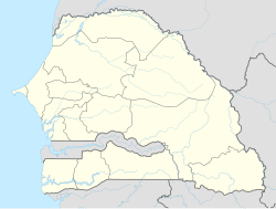
Gossas is a town and urban commune in Fatick Region in western Senegal, about 90 km from the capital.
Transport
The town is served by a station on the Dakar-Niger Railway.
See also
References
- ^ Citypopulation.de Population and area of Gossas Commune
14°30′00″N 16°04′00″W / 14.50000°N 16.06667°W

