Gautegiz Arteaga: Difference between revisions
Appearance
Content deleted Content added
No edit summary |
No edit summary |
||
| Line 10: | Line 10: | ||
| image_flag = |
| image_flag = |
||
| flag_alt = |
| flag_alt = |
||
| |
| image_shield = Escudo_de_Gautegiz_Arteaga.svg |
||
| seal_alt = |
|||
| image_shield = |
|||
| shield_alt = |
| shield_alt = |
||
| nickname = |
| nickname = |
||
Revision as of 04:14, 21 August 2024
Gautegiz Arteaga
Gautéguiz de Arteaga | |
|---|---|
 | |
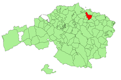
 Location in Biscay | |
| Coordinates: 43°22′5″N 2°39′8″W / 43.36806°N 2.65222°W | |
| Kintra | |
| Autonomous community | |
| Province | Biscay |
| Comarca | Busturialdea |
| Area | |
• Total | 13.57 km2 (5.24 sq mi) |
| Elevation | 45 m (148 ft) |
| Population (2018)[1] | |
• Total | 840 |
| • Density | 62/km2 (160/sq mi) |
Gautegiz Arteaga (Template:Lang-es) is a town in Biscay, in the northern Spanish autonomous community of the Basque Country.
It is located on the right bank of the Urdaibai estuary.
Its most emblematic building is the Arteaga Tower, a medieval castle rebuilt in the 19th century for the French empress Eugénie de Montijo.

References
- ^ Municipal Register of Spain 2018. National Statistics Institute.


