Arzon: Difference between revisions
mayor, reference |
RodRabelo7 (talk | contribs) |
||
| Line 24: | Line 24: | ||
|image flag=Flag of Arzon.gif}} |
|image flag=Flag of Arzon.gif}} |
||
'''Arzon''' ({{IPA |
'''Arzon''' ({{IPA|fr|aʁzɔ̃}}) or ''Arzhon-Rewiz'' in [[Breton language|Breton]] ({{IPA-br|aʁxɔ̃n rewis}}) is a [[Communes of France|commune]] located at the extremity of the [[Rhuys]] peninsula in the [[Morbihan]] [[Departments of France|department]] in the [[Brittany (administrative region)|Brittany]] [[Regions of France|region]] in northwestern [[France]]. |
||
==Geography== |
==Geography== |
||
Latest revision as of 12:26, 22 August 2024
Arzon
Arzhon-Rewiz | |
|---|---|
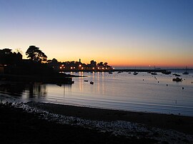
 Port-Navalo | |
| Coordinates: 47°32′55″N 2°53′25″W / 47.5486°N 2.8903°W | |
| Country | France |
| Region | Brittany |
| Department | Morbihan |
| Arrondissement | Vannes |
| Canton | Séné |
| Intercommunality | Golfe du Morbihan - Vannes Agglomération |
| Government | |
| • Mayor (2023–2026) | Frédérique Gauvain[1] |
Area 1 | 8.93 km2 (3.45 sq mi) |
| Population (2021)[2] | 2,269 |
| • Density | 250/km2 (660/sq mi) |
| Time zone | UTC+01:00 (CET) |
| • Summer (DST) | UTC+02:00 (CEST) |
| INSEE/Postal code | 56005 /56640 |
| Elevation | 0–36 m (0–118 ft) |
| 1 French Land Register data, which excludes lakes, ponds, glaciers > 1 km2 (0.386 sq mi or 247 acres) and river estuaries. | |
Arzon (French pronunciation: [aʁzɔ̃]) or Arzhon-Rewiz in Breton (Breton pronunciation: [aʁxɔ̃n rewis]) is a commune located at the extremity of the Rhuys peninsula in the Morbihan department in the Brittany region in northwestern France.
Geography
[edit]Arzon is said to be the French village with the longest coastal area in France (see map). Arzon marks the east entrance to the Gulf of Morbihan.
There are two seaside resorts in the commune:
- Port-Navalo (Porzh Noalou Breton pronunciation: [pɔʁx nœa'lœɥ]), dating from the nineteenth century
- Le Crouesty (Ar C'hroesti Breton pronunciation: [œr xʁœes'tɛj]), in constant development since the 1970s
Several hamlets are located on the territory of the commune: Monteno, Kerners, Béninze, Tumiac, Kerjouanno.
Tourism
[edit]Arzon is a popular summer resort. In winter, fall and spring, only two "gendarmes" (French military police) work in Arzon, but in the summer there are far more to cope with the influx of tourists.
Population
[edit]| Year | Pop. | ±% p.a. |
|---|---|---|
| 1968 | 1,308 | — |
| 1975 | 1,326 | +0.20% |
| 1982 | 1,476 | +1.54% |
| 1990 | 1,754 | +2.18% |
| 1999 | 2,056 | +1.78% |
| 2007 | 2,173 | +0.69% |
| 2012 | 2,103 | −0.65% |
| 2017 | 2,073 | −0.29% |
| Source: INSEE[3] | ||
Inhabitants of Arzon are called Arzonais in French.
International relations
[edit]Arzon is twinned with Lahinch, Ireland.
See also
[edit]References
[edit]- ^ "Répertoire national des élus: les maires" (in French). data.gouv.fr, Plateforme ouverte des données publiques françaises. 30 November 2023.
- ^ "Populations légales 2021" (in French). The National Institute of Statistics and Economic Studies. 28 December 2023.
- ^ Population en historique depuis 1968, INSEE
External links
[edit]- Arzon Town Hall
- Arzon Tourist Office
- Yacht Club Crouesty Arzon
- Base Mérimée: Search for heritage in the commune, Ministère français de la Culture. (in French)


