Cape Cà Mau: Difference between revisions
Appearance
Content deleted Content added
Loginnigol (talk | contribs) near |
minor fixes, replaced: Ca Mau → Cà Mau (2), province]] → Province]], Province → province (2), Ngọc Hiển District → Ngọc Hiển district |
||
| Line 11: | Line 11: | ||
| map_width = |
| map_width = |
||
| map_caption = |
| map_caption = |
||
| location = [[Đất Mũi]], [[Ngọc Hiển |
| location = [[Đất Mũi]], [[Ngọc Hiển district]], [[Cà Mau province]], [[Vietnam]] |
||
| water_bodies = [[South China Sea]] |
| water_bodies = [[South China Sea]] |
||
| coordinates = {{coord|8|37|23|N|104|42|36|E|source:kolossus-viwiki|display=inline,title}} |
| coordinates = {{coord|8|37|23|N|104|42|36|E|source:kolossus-viwiki|display=inline,title}} |
||
| Line 19: | Line 19: | ||
}} |
}} |
||
'''Cape Cà Mau''' (''Mũi Cà Mau'') is a cape on the [[Cà Mau Peninsula]] in [[Vietnam]]. It is near the southernmost tip of the [[Vietnam |
'''Cape Cà Mau''' (''Mũi Cà Mau'') is a cape on the [[Cà Mau Peninsula]] in [[Vietnam]]. It is near the southernmost tip of the [[Vietnam]]ese mainland. |
||
==Gallery== |
==Gallery== |
||
<gallery> |
<gallery> |
||
File:Tuongdaimuicamau.jpg|The ship-shaped monument marks the geographical location of Cape |
File:Tuongdaimuicamau.jpg|The ship-shaped monument marks the geographical location of Cape Cà Mau |
||
File:Mui Ca Mau 005.JPG|The cape at sunset |
File:Mui Ca Mau 005.JPG|The cape at sunset |
||
File:Satellite picture of Ca Mau 2020-12-21-00 00 2020-12-21-23 59 Sentinel-2 L2A.jpg|Satellite view |
File:Satellite picture of Ca Mau 2020-12-21-00 00 2020-12-21-23 59 Sentinel-2 L2A.jpg|Satellite view |
||
Latest revision as of 18:50, 5 September 2024
Cape Cà Mau
Mũi Cà Mau | |
|---|---|
 | |
| Coordinates: 8°37′23″N 104°42′36″E / 8.62306°N 104.71000°E | |
| Location | Đất Mũi, Ngọc Hiển district, Cà Mau province, Vietnam |
| Offshore water bodies | South China Sea |
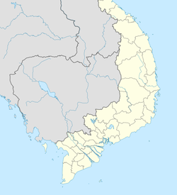
Cape Cà Mau (Mũi Cà Mau) is a cape on the Cà Mau Peninsula in Vietnam. It is near the southernmost tip of the Vietnamese mainland.
Gallery
[edit]-
The ship-shaped monument marks the geographical location of Cape Cà Mau
-
The cape at sunset
-
Satellite view
See also
[edit]References
[edit]


