Caldas Department: Difference between revisions
Untitledjuan (talk | contribs) No edit summary |
No edit summary |
||
| Line 65: | Line 65: | ||
| demographics1_info1 = [[Colombian peso|COP]] 23,953 billion<br />([[US$]] 5.6 billion) |
| demographics1_info1 = [[Colombian peso|COP]] 23,953 billion<br />([[US$]] 5.6 billion) |
||
| blank_name_sec2 = [[Human Development Index|HDI]] (2019) |
| blank_name_sec2 = [[Human Development Index|HDI]] (2019) |
||
| blank_info_sec2 = 0. |
| blank_info_sec2 = 0.769<ref name="GlobalDataLab">{{Cite web|url=https://hdi.globaldatalab.org/areadata/shdi/|title=Sub-national HDI - Area Database - Global Data Lab|website=hdi.globaldatalab.org|language=en|access-date=2018-09-13}}</ref><br/>{{color|#0c0|high}} · [[List of Colombian departments by Human Development Index|6th of 33]] |
||
| timezone1 = [[UTC-05]] |
| timezone1 = [[UTC-05]] |
||
| postal_code_type = |
| postal_code_type = |
||
Revision as of 22:32, 5 October 2024
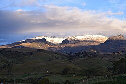
Department of Caldas
Departamento de Caldas | |
|---|---|
 | |
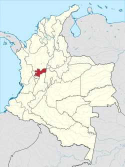
 Caldas shown in red | |
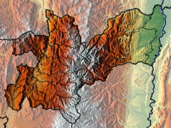
 Topography of the department | |
| Coordinates: 5°06′N 75°33′W / 5.100°N 75.550°W | |
| Country | |
| Region | Andean Region |
| Department | 1905 |
| Capital | Manizales |
| Government | |
| • Governor | Henry Gutiérrez Ángel (2024-2027) |
| Area | |
• Total | 7,888 km2 (3,046 sq mi) |
| • Rank | 28th |
| Population (2018)[1] | |
• Total | 998,255 |
| • Rank | 17th |
| • Density | 130/km2 (330/sq mi) |
| GDP | |
| • Total | COP 23,953 billion (US$ 5.6 billion) |
| Time zone | UTC-05 |
| ISO 3166 code | CO-CAL |
| Municipalities | 27 |
| HDI (2019) | 0.769[3] high · 6th of 33 |
| Website | gobernaciondecaldas.gov.co |
Caldas (Spanish pronunciation: [ˈkaldas]) is a department of Colombia named after Colombian patriotic figure Francisco José de Caldas. It is part of the Paisa Region and its capital is Manizales. The population of Caldas is 998,255, and its area is 7,291 km2. Caldas is also part of the Colombian Coffee-Growers Axis region along with the Risaralda and Quindio departments, which were politically separated from Caldas in 1966.
Subdivisions
Municipalities
Districts
Caldas has 6 districts.
Dams
The Miel I Dam is situated in Caldas.[4]
Demography
| Year | Pop. | ±% |
|---|---|---|
| 1938 | 769,968 | — |
| 1951 | 1,067,324 | +38.6% |
| 1964 | 712,916 | −33.2% |
| 1973 | 698,042 | −2.1% |
| 1985 | 883,024 | +26.5% |
| 1993 | 1,030,062 | +16.7% |
| 2005 | 968,740 | −6.0% |
| 2018 | 998,255 | +3.0% |
| Source:[5] | ||
The population of Caldas is 984,128 (2013), half of whom live in Manizales. The racial composition is:
- White / Mestizo (93.16%)
- Amerindian or Indigenous (4.29%)
- Black or Afro-Colombian (2.54%)
The local inhabitants of Caldas are known as caldenses. Of the five main regional groups in Colombia, the predominant group in Caldas are known as paisa, referring to those living in the Paisa region, which covers most of Antioquia, as well as the departments of Caldas, Risaralda and Quindío.
References
- ^ "DANE". Archived from the original on November 13, 2009. Retrieved February 13, 2013.
- ^ "Producto Interno Bruto por departamento", www.dane.gov.co
- ^ "Sub-national HDI - Area Database - Global Data Lab". hdi.globaldatalab.org. Retrieved 2018-09-13.
- ^ Ingetec.com.co Archived 2009-03-27 at the Wayback Machine
- ^ "Reloj de Población". DANE. Departamento Administrativo Nacional de Estadísitica. Archived from the original on 28 October 2016. Retrieved 6 July 2017.
External links
- Government of Caldas official website (in Spanish)


