Fraize: Difference between revisions
Appearance
Content deleted Content added
HagridLiving (talk | contribs) No edit summary |
HagridLiving (talk | contribs) |
||
| Line 26: | Line 26: | ||
== Geography == |
== Geography == |
||
Fraize is a municipality in the [[Vosges|Vosges Mountains]] located in the [[Ballons des Vosges Nature Park]],<ref>{{Cite web |title=Le Parc en chiffres {{!}} PnrBV |url=https://www.parc-ballons-vosges.fr/comprendre/parc-naturel-regional-ballons-vosges/le-parc-en-chiffres/ |access-date=2024-10-28 |website=Parc naturel régional des Ballons des Vosges}}</ref> to the east of the department, between [[Saint-Dié-des-Vosges]] (11.8 |
Fraize is a municipality in the [[Vosges|Vosges Mountains]] located in the [[Ballons des Vosges Nature Park]],<ref>{{Cite web |title=Le Parc en chiffres {{!}} PnrBV |url=https://www.parc-ballons-vosges.fr/comprendre/parc-naturel-regional-ballons-vosges/le-parc-en-chiffres/ |access-date=2024-10-28 |website=Parc naturel régional des Ballons des Vosges}}</ref> to the east of the department, between [[Saint-Dié-des-Vosges]] ({{convert|11.8|km|mi|abbr=on}}), [[Gérardmer]] ({{convert|15.3|km|mi|abbr=on}}), and [[Colmar]] ({{convert|28.9|km|mi|abbr=on}}). The neighboring municipalities are [[Plainfaing]], [[Ban-sur-Meurthe-Clefcy]], [[Anould]], [[Saint-Léonard, Vosges|Saint-Léonard]], [[Mandray]], and [[La Croix-aux-Mines]] in the Vosges, and [[Le Bonhomme]] in the [[Haut-Rhin]]. |
||
==Population== |
==Population== |
||
Latest revision as of 19:20, 28 October 2024
Fraize | |
|---|---|
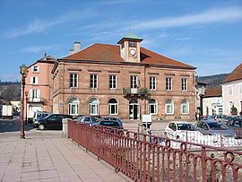
 Town hall | |
| Coordinates: 48°11′11″N 7°00′08″E / 48.1864°N 7.0022°E | |
| Country | France |
| Region | Grand Est |
| Department | Vosges |
| Arrondissement | Saint-Dié-des-Vosges |
| Canton | Gérardmer |
| Intercommunality | CA Saint-Dié-des-Vosges |
| Government | |
| • Mayor (2020–2026) | Caroline Lerognon[1] |
Area 1 | 15.59 km2 (6.02 sq mi) |
| Population (2021)[2] | 2,846 |
| • Density | 180/km2 (470/sq mi) |
| Time zone | UTC+01:00 (CET) |
| • Summer (DST) | UTC+02:00 (CEST) |
| INSEE/Postal code | 88181 /88230 |
| Elevation | 468–1,131 m (1,535–3,711 ft) (avg. 507 m or 1,663 ft) |
| 1 French Land Register data, which excludes lakes, ponds, glaciers > 1 km2 (0.386 sq mi or 247 acres) and river estuaries. | |
Fraize (French pronunciation: [fʁɛz] ) is a commune in the Vosges department in Grand Est in northeastern France about 25 miles from Colmar.
Geography
[edit]Fraize is a municipality in the Vosges Mountains located in the Ballons des Vosges Nature Park,[3] to the east of the department, between Saint-Dié-des-Vosges (11.8 km (7.3 mi)), Gérardmer (15.3 km (9.5 mi)), and Colmar (28.9 km (18.0 mi)). The neighboring municipalities are Plainfaing, Ban-sur-Meurthe-Clefcy, Anould, Saint-Léonard, Mandray, and La Croix-aux-Mines in the Vosges, and Le Bonhomme in the Haut-Rhin.
Population
[edit]| Year | Pop. | ±% p.a. |
|---|---|---|
| 1968 | 3,486 | — |
| 1975 | 3,367 | −0.49% |
| 1982 | 3,357 | −0.04% |
| 1990 | 3,049 | −1.20% |
| 1999 | 2,990 | −0.22% |
| 2007 | 3,058 | +0.28% |
| 2012 | 3,069 | +0.07% |
| 2017 | 2,871 | −1.32% |
| Source: INSEE[4] | ||
Twin communes
[edit]Since 1998 Fierzë, Albania is a twin commune of Fraize.
See also
[edit]References
[edit]- ^ "Répertoire national des élus: les maires" (in French). data.gouv.fr, Plateforme ouverte des données publiques françaises. 13 September 2022.
- ^ "Populations légales 2021" (in French). The National Institute of Statistics and Economic Studies. 28 December 2023.
- ^ "Le Parc en chiffres | PnrBV". Parc naturel régional des Ballons des Vosges. Retrieved 2024-10-28.
- ^ Population en historique depuis 1968, INSEE
External links
[edit]Wikimedia Commons has media related to Fraize.
- Town website (in French)


