Ölziit, Arkhangai: Difference between revisions
Appearance
Content deleted Content added
m →References: remove Category:Populated places in Mongolia; excessive |
add map per WP:MAPS |
||
| Line 18: | Line 18: | ||
| image_blank_emblem = |
| image_blank_emblem = |
||
| blank_emblem_size = |
| blank_emblem_size = |
||
| image_map = |
| image_map = Архангайн Өлзийт.PNG |
||
| mapsize = |
| mapsize = 220px |
||
| map_caption = |
| map_caption = Ölziit Disrict in Arkhangai Province |
||
| image_map1 = |
| image_map1 = |
||
| mapsize1 = 150px |
| mapsize1 = 150px |
||
Revision as of 05:43, 31 October 2024
Ölziit District
Өлзийт сум ᠥᠯᠵᠡᠶᠢᠲᠦᠰᠤᠮᠤ | |
|---|---|
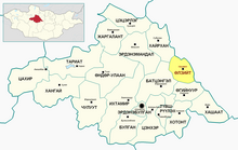
 Ölziit Disrict in Arkhangai Province | |
| Country | Mongolia |
| Province | Arkhangai Province |
| Area | |
• Total | 1,700 km2 (700 sq mi) |
| Time zone | UTC+8 (UTC + 8) |
Ölziit (Template:Lang-mn, Blessed) is a sum (district) of Arkhangai Province in central Mongolia. There is a concrete bridge over the Orkhon River just east of the sum center. In 2009, its population was 3,102.[1]
References
- ^ Dec. 31 2009 estimation. Arkhangai Aimag Statistical Service Archived July 22, 2011, at the Wayback Machine
48°06′02″N 102°33′30″E / 48.10056°N 102.55833°E

