Nesvík: Difference between revisions
Appearance
Content deleted Content added
Fixed type from 'de facto abandaned' to 'de facto abandoned' Tags: Mobile edit Mobile web edit |
mNo edit summary |
||
| Line 29: | Line 29: | ||
|subdivision_name2 = [[Streymoy]] |
|subdivision_name2 = [[Streymoy]] |
||
|subdivision_type3 = Municipality |
|subdivision_type3 = Municipality |
||
|subdivision_name3 = [[Sunda, Faroe Islands|Sunda |
|subdivision_name3 = [[Sunda, Faroe Islands|Sunda]] |
||
|<!-- Politics -----------------> |
|<!-- Politics -----------------> |
||
|government_footnotes = |
|government_footnotes = |
||
| Line 49: | Line 49: | ||
|population_footnotes = |
|population_footnotes = |
||
|population_note = |
|population_note = |
||
|population_total = |
|population_total = 0 |
||
|population_density_km2 = |
|population_density_km2 = |
||
|population_density_sq_mi = |
|population_density_sq_mi = |
||
Latest revision as of 00:35, 4 November 2024
Nesvík | |
|---|---|
Village | |
 | |
| Coordinates: 62°12′35″N 7°0′30″W / 62.20972°N 7.00833°W | |
| State | |
| Constituent country | |
| Island | Streymoy |
| Municipality | Sunda |
| Population (1 May 2023[1]) | |
• Total | 0 |
| Time zone | GMT |
| • Summer (DST) | UTC+1 (EST) |
| Postal code | FO 437 |
| Climate | Cfc |
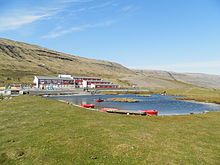
Nesvík is a village on the east coast of the Faroese island of Streymoy, located in the Sunda municipality.

In 2023 its population was 0 with the last inhabitants leaving in 2016. Nesvík is home to a religious camp of the conservative Inner Mission of the national church, and a conference center called Leguhusið í Nesvík. Its name is derived from the Faroese words for cape and bay.
See also
[edit]References
[edit]External links
[edit]- Evangeliihúsið in Torshavn, sponsors of activities in Nesvík
- Danish website with photos of Nesvík

