Peltuinum: Difference between revisions
No edit summary |
Randy Kryn (talk | contribs) uppercased first letter of caption, uppercase per direct link (Apennine Mountains) |
||
| Line 35: | Line 35: | ||
}} |
}} |
||
[[File:Via Claudia Nova.jpg|thumb|300px|Via Claudia Nova (in yellow)]] |
[[File:Via Claudia Nova.jpg|thumb|300px|Via Claudia Nova (in yellow)]] |
||
[[File:AbrPeltuinum3.jpg|thumb|350px| |
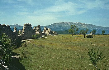
[[File:AbrPeltuinum3.jpg|thumb|350px|City walls]] |
||
'''Peltuinum''' was a [[Roman Empire|Roman]] town of the [[Vestini]], on the ancient [[Via Claudia Nova]], 20 km east of [[L'Aquila]], [[Italy]],<ref name="Chisholm 1911, p. 77">{{EB1911 |inline=1 |wstitle=Peltuinum |volume=21| page=77}}</ref> between the modern-day settlements of [[Prata d'Ansidonia]] and [[Castelnuovo, San Pio delle Camere|Castelnuovo]].<ref>{{cite web|title=The Ancient Town of Peltuinum|url=http://santatatiana.wordpress.com/2010/06/26/the-ancient-town-of-peltuinum/|accessdate=23 December 2013}}</ref> |
'''Peltuinum''' was a [[Roman Empire|Roman]] town of the [[Vestini]], on the ancient [[Via Claudia Nova]], 20 km east of [[L'Aquila]], [[Italy]],<ref name="Chisholm 1911, p. 77">{{EB1911 |inline=1 |wstitle=Peltuinum |volume=21| page=77}}</ref> between the modern-day settlements of [[Prata d'Ansidonia]] and [[Castelnuovo, San Pio delle Camere|Castelnuovo]].<ref>{{cite web|title=The Ancient Town of Peltuinum|url=http://santatatiana.wordpress.com/2010/06/26/the-ancient-town-of-peltuinum/|accessdate=23 December 2013}}</ref> |
||
It was apparently the chief town of that portion of the Vestini who dwelt west of the main [[Apennine |
It was apparently the chief town of that portion of the Vestini who dwelt west of the main [[Apennine Mountains|Apennine chain]]. Remains of the town walls, of an [[amphitheatre]], of a temple and of other buildings still exist.<ref name="Chisholm 1911, p. 77"/> The city was the birthplace of [[Gnaeus Domitius Corbulo]], a Roman general from the age of [[Nero]]. |
||
== History == |
== History == |
||
Revision as of 15:40, 19 November 2024
 Part of the remaining town wall. | |
| Location | Prata d'Ansidonia, Province of L'Aquila, Abruzzo, Italy |
|---|---|
| Type | Settlement |
| History | |
| Periods | Roman Republic - Byzantine Empire |
| Cultures | Ancient Rome |
| Site notes | |
| Public access | yes |
| Website | https://www.peltuinum.org |


Peltuinum was a Roman town of the Vestini, on the ancient Via Claudia Nova, 20 km east of L'Aquila, Italy,[1] between the modern-day settlements of Prata d'Ansidonia and Castelnuovo.[2]
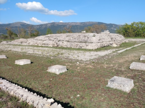
It was apparently the chief town of that portion of the Vestini who dwelt west of the main Apennine chain. Remains of the town walls, of an amphitheatre, of a temple and of other buildings still exist.[1] The city was the birthplace of Gnaeus Domitius Corbulo, a Roman general from the age of Nero.
History
Roman age
The foundation of Peltuinum was in the middle of the 1st century BC. At the turn of the first century AD the city wall and a monumental sanctuary area were built of which excavations have brought to light a temple and a theatre.
In 47 AD the L'Aquila-Foggia road from Sabina towards the market centres of Arpi and Lucera was structured as via Claudia Nova with the consequent monumentalisation of the stretch that crossed the town.
Late Antiquity and Middle Ages
Ancient sources mention a strong earthquake in the 5th century that affected Rome as well as a large part of central Italy, and the earthquake of 443 damaged Peltuinum. The population began to abandon the city, also due to the wars that increasingly marked the weakness of the Empire. The community moved towards more defensible areas and the main buildings of the city were used as quarries.
During the Greek-Gothic war the territory of Peltuinum, like that of nearby Alba Fucens, were the sites of Byzantine camps of general Belisarius.
The site

Peltuinum stands on a plateau over 100 m above the surroundings. The walled area has an area of about 26 hectares. The centre is crossed east to west by the via Claudia Nova.
The walls
The walls are along the edge of a slope with a plinth in opus incertum. The double-arched west gate is the only one that is preserved. After the Romans it was used as a control gate for the passage of livestock and between the towers is a space for the customs offices. The customs function was maintained for centuries.
Sanctuary
The temple overlooked the square and was a Corinthian hexastyle prostyle, with three columns on the extension of the doors and a cella with a colonnade of perhaps two orders, with the base for the cult statue on the back wall.
The cella of the temple was built above a spring which must have been a sacred element in the Vestine period.
The discovery of a fragmentary votive table with the dedication APELLUNE (= Apollini), reused as the threshold of one of the shops facing via Claudia Nova, in the central area of the city, has led to the hypothesis that the temple was dedicated to Apollo.
The temple is framed by a U-shaped portico, on a single level and with a double nave with a spine colonnade. The fourth side, the northern one, is enclosed by walls which join the portico to the temple at the level of the pronaos. There were two entrances on the northern side of the portico (the side facing the forum square) and two at the southernmost point of the east and west arms.
Theatre
The theatre used the hillside for part of the seating and only the southern sector was supported by radial walls. The theatre was damaged by minor earthquakes.
References
- ^ a b One or more of the preceding sentences incorporates text from a publication now in the public domain: Chisholm, Hugh, ed. (1911). "Peltuinum". Encyclopædia Britannica. Vol. 21 (11th ed.). Cambridge University Press. p. 77.
- ^ "The Ancient Town of Peltuinum". Retrieved 23 December 2013.
42°17′09″N 13°37′13″E / 42.28583°N 13.62028°E
