Tutuila: Difference between revisions
Appearance
Content deleted Content added
No edit summary |
No edit summary |
||
| Line 26: | Line 26: | ||
|} |
|} |
||
<!-- END WikiProject Mountains infobox --> |
<!-- END WikiProject Mountains infobox --> |
||
==Sources== |
|||
{{Global Volcanism Program}} |
|||
[[Category:Islands]] |
|||
[[Category:Volcanoes of American Samoa]] |
|||
[[Category:Mountains of the United States]] |
|||
Revision as of 00:47, 1 May 2005
| Tutuila | |
|---|---|
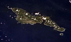
 Tutuila from Space Shuttle. | |
| Elevation: | 653 m (2,142 feet) |
| Latitude: | 14.295° S |
| Longitude: | 14.295° S |
| Location: | United States |
| Range: | Samoa Islands |
| Type: | Tuff cones |
| Last eruption: | Unknown |
| First ascent: | |
| Easiest route: | |
Tutuila is an island in the main island of American Samoa. The capitol of American Samoa, Pago Pago is also located on the island. The island is 135 square killometers with an estimated population in 1990 of 45,043. The highest point on the island is Matafao peak. The island is also host to the Tutuila island volcano.
Sources
- Siebert L, Simkin T (2002–present). Volcanoes of the World: an Illustrated Catalog of Holocene Volcanoes and their Eruptions. Smithsonian Institution, Global Volcanism Program Digital Information Series, GVP-3 (http://www.volcano.si.edu).
Ľ
