Daet: Difference between revisions
Appearance
Content deleted Content added
| Line 25: | Line 25: | ||
* Mancruz |
* Mancruz |
||
* Pamorangon |
* Pamorangon |
||
* Barangay I/Ilaod(Pob.) |
* Barangay I/Ilaod (Pob.) |
||
* Barangay II/Pasig(Pob.) |
* Barangay II/Pasig (Pob.) |
||
* Barangay III/Iraya(Pob.) |
* Barangay III/Iraya (Pob.) |
||
* Barangay IV/Mantagbac(Pob.) |
* Barangay IV/Mantagbac (Pob.) |
||
* Barangay V/Pandan(Pob.) |
* Barangay V/Pandan (Pob.) |
||
* Barangay VI (Pob.) |
* Barangay VI (Pob.) |
||
* Barangay VII (Pob.) |
* Barangay VII (Pob.) |
||
* Barangay VIII/Salcedo(Pob.) |
* Barangay VIII/Salcedo (Pob.) |
||
* San Isidro |
* San Isidro |
||
</td></tr></table> |
</td></tr></table> |
||
Revision as of 09:40, 3 June 2007

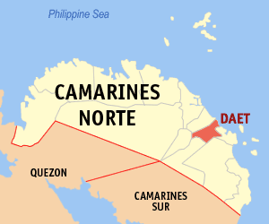
Daet is a 1st class municipality in the province of Camarines Norte, Philippines. It is the capital municipality of Camarines Norte. According to the 2000 census, it has a population of 80,632 people in 16,267 households.
Barangays
Daet is politically subdivided into 25 barangays.
|
|
