Mid Devon: Difference between revisions
mNo edit summary |
|||
| Line 55: | Line 55: | ||
---- |
---- |
||
==References== |
|||
<references/> |
|||
{{SW_England}} |
{{SW_England}} |
||
Revision as of 10:14, 16 September 2007
| Mid Devon District | |
|---|---|
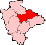
 Shown within Devon | |
| Geography | |
| Status: | District |
| Region: | South West England |
| Admin. County: | Devon |
| Area: - Total |
Ranked 33rd 912.94 km² |
| Admin. HQ: | Tiverton |
| ONS code: | 18UD |
| Demographics | |
| Population: - Total (2022) - Density |
Ranked / km² |
| Ethnicity: | 99.2% White |
| Politics | |
| Mid Devon District Council http://www.middevon.gov.uk/ | |
| Leadership: | Alternative - Sec.31 |
| Control: | |
| MPs: | Angela Browning, Nick Harvey |
Mid Devon is a local government district in Devon, England. Its council is based in Tiverton.
The district was formed under the Local Government Act 1972, on April 1, 1974 by the merger of the borough of Tiverton and Crediton urban district together with Tiverton Rural District, and Crediton Rural District. It was originally called the Tiverton district, and was renamed in 1978 (the first year that this was allowed under section 74 of the LGA).
Geography
Mid Devon shares borders with several other Devon districts as well as the county of Somerset. Neighbouring districts include Exeter, East Devon, North Devon, Teignbridge, West Devon and Torridge.
Rivers running through Mid Devon
Several rivers run through the district of Mid Devon, including the Exe, the Culm and the Yeo.
Grand Western Canal
The Grand Western Canal stretches from Canal Hill in Tiverton to just outside Greenham in Somerset.
Raddon Top
Raddon Top (772ft.) is a landmark for 20 miles around. Westcote tells us that there was an earthwork on the summit, practically ploughed down even in his day. The views from here are superb, even for Devon.[1]
Major Settlements
Several towns and large villages exist in Mid Devon. The major towns include Tiverton, Cullompton and Crediton.
