Iténez Province: Difference between revisions
Appearance
Content deleted Content added
Dr. Blofeld (talk | contribs) |
MJCdetroit (talk | contribs) Started Infobox and imported some data from Español wiki |
||
| Line 1: | Line 1: | ||
{{Infobox Settlement |
|||
|name =Iténez |
|||
|settlement_type =Province <!--For Town or Village (Leave blank for the default City)--> |
|||
|official_name = |
|||
|other_name = |
|||
|native_name = |
|||
|nickname = |
|||
|motto = |
|||
|image_skyline = |
|||
|imagesize = |
|||
|image_caption = |
|||
|image_flag = |
|||
|flag_size = |
|||
|image_seal = |
|||
|seal_size = |
|||
|image_shield = |
|||
|shield_size = |
|||
|image_blank_emblem = |
|||
|blank_emblem_size = |
|||
|image_map = Bolivia Beni Iténez.png<!-- Bolivia department of beni.png --> |
|||
|mapsize = 200px |
|||
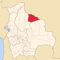
|map_caption = Map of Bolivia highlighting the province of Iténez within the Beni Department. |
|||
|image_map1 = <!-- Bolivia-Beni.png --> |
|||
|mapsize1 = 150px |
|||
|map_caption1 =<!-- Map of Bolivia highlighting the Beni Deptment --> |
|||
|pushpin_map = |
|||
|pushpin_label_position = |
|||
|subdivision_type = [[Countries of the world|Country]] |
|||
|subdivision_name = {{BOL}} |
|||
|subdivision_type1 = [[Departments of Bolivia|Departament]] |
|||
|subdivision_name1 = [[Beni Department|Beni]] |
|||
|subdivision_type2 = |
|||
|subdivision_name2 = |
|||
|seat_type = |
|||
|seat = |
|||
|parts_type =Settlements |
|||
|parts_style = <!-- =list (for list), coll (for collapsed list), para (for paragraph format) |
|||
Default is list if up to 5 items, coll if more than 5--> |
|||
|parts =List <!-- parts text, or header for parts list --> |
|||
|p1 =Magdalena |
|||
|p2 =Baures |
|||
|p3 =Huacaraje <!-- etc. up to p50: for separate parts to be listed--> |
|||
|government_type = |
|||
|leader_title = |
|||
|leader_name = |
|||
|leader_title1 = <!-- for places with, say, both a mayor and a city manager --> |
|||
|leader_name1 = |
|||
|established_title = |
|||
|established_date = |
|||
|area_magnitude = |
|||
|unit_pref =Imperial<!--Enter: Imperial, if Imperial (metric) is desired--> |
|||
|area_footnotes = |
|||
|area_total_km2 = 36576 |
|||
|area_land_km2 = |
|||
|area_water_km2 = |
|||
|area_total_sq_mi = 14122 |
|||
|area_land_sq_mi = |
|||
|area_water_sq_mi = |
|||
|area_water_percent = |
|||
|area_urban_km2 = |
|||
|area_urban_sq_mi = |
|||
|area_metro_km2 = |
|||
|area_metro_sq_mi = |
|||
|population_as_of = 2006 |
|||
|population_footnotes = <ref>[[Instituto Nacional de Estadística de Bolivia]]</ref> |
|||
|population_note = |
|||
|population_total = 20190 |
|||
|population_density_km2 = 0.55 |
|||
|population_density_sq_mi = |
|||
|population_metro = |
|||
|population_density_metro_km2 = |
|||
|population_density_metro_sq_mi = |
|||
|population_urban = |
|||
|population_density_urban_km2 = |
|||
|population_density_urban_mi2 = |
|||
|timezone = GMT -4 |
|||
|utc_offset = -4 |
|||
|timezone_DST = |
|||
|utc_offset_DST = |
|||
|latd=|latm=|lats=|latNS= |
|||
|longd=|longm=|longs= |longEW= |
|||
|elevation_footnotes = <!--for references: use <ref> </ref> tags--> |
|||
|elevation_m = |
|||
|elevation_ft = |
|||
|postal_code_type = <!-- enter ZIP code, Postcode, Post code, Postal code... --> |
|||
|postal_code = |
|||
|area_code = |
|||
|website = |
|||
|footnotes = |
|||
}} |
|||
'''Iténez''' is a [[province]] in the [[Beni Department]], [[Bolivia]]. |
'''Iténez''' is a [[province]] in the [[Beni Department]], [[Bolivia]]. |
||
Revision as of 02:06, 24 January 2008
Iténez | |
|---|---|
Province | |
 Map of Bolivia highlighting the province of Iténez within the Beni Department. | |
| Country | |
| Departament | Beni |
| Settlements | List
|
| Area | |
• Total | 14,122 sq mi (36,576 km2) |
| Population (2006)[1] | |
• Total | 20,190 |
| • Density | 1.4/sq mi (0.55/km2) |
| Time zone | UTC-4 (GMT -4) |
Iténez is a province in the Beni Department, Bolivia.

