Madison River: Difference between revisions
m Added hyperlink for Gibbon River |
m Adjusted the Gibbon river hyperlink |
||
| Line 6: | Line 6: | ||
The '''Madison River''' is a headwater [[tributary]] of the [[Missouri River]], approximately 183 miles (295 km) long, in the [[U.S. state]]s of [[Wyoming]] and [[Montana]]. Its [[confluence]] with the [[Jefferson River|Jefferson]] and [[Gallatin River|Gallatin]] rivers near [[Three Forks, Montana]] form the Missouri River. |
The '''Madison River''' is a headwater [[tributary]] of the [[Missouri River]], approximately 183 miles (295 km) long, in the [[U.S. state]]s of [[Wyoming]] and [[Montana]]. Its [[confluence]] with the [[Jefferson River|Jefferson]] and [[Gallatin River|Gallatin]] rivers near [[Three Forks, Montana]] form the Missouri River. |
||
The Madison rises in [[Park County, Wyoming|Park County]] in northwestern Wyoming at the confluence of the [[Firehole River|Firehole]] and [[Gibbon River]], a location known as Madison Junction in [[Yellowstone National Park]]. It flows west then north through the mountains of southwestern Montana to join the Jefferson and Gallatin rivers at Three Forks. The Missouri River Headwaters State Park is located on the Madison at Three Forks.<ref>[http://fwp.mt.gov/lands/site_281910.aspx Montana Fish and Wildlife and Parks]</ref> In its upper reaches in [[Gallatin County, Montana]], the Hebgen Dam forms [[Hebgen Lake]]. In its middle reaches in [[Madison County, Montana]], the Madison Dam forms [[Ennis Lake]] and provides [[hydroelectric power]]. In 1959, an [[earthquake]] formed [[Quake Lake]] just downstream from Hebgen Dam. |
The Madison rises in [[Park County, Wyoming|Park County]] in northwestern Wyoming at the confluence of the [[Firehole River|Firehole]] and [[Gibbon River|Gibbon]] rivers, a location known as Madison Junction in [[Yellowstone National Park]]. It flows west then north through the mountains of southwestern Montana to join the Jefferson and Gallatin rivers at Three Forks. The Missouri River Headwaters State Park is located on the Madison at Three Forks.<ref>[http://fwp.mt.gov/lands/site_281910.aspx Montana Fish and Wildlife and Parks]</ref> In its upper reaches in [[Gallatin County, Montana]], the Hebgen Dam forms [[Hebgen Lake]]. In its middle reaches in [[Madison County, Montana]], the Madison Dam forms [[Ennis Lake]] and provides [[hydroelectric power]]. In 1959, an [[earthquake]] formed [[Quake Lake]] just downstream from Hebgen Dam. |
||
The river was named by [[Lewis and Clark]] in July 1805, for US Secretary of State [[James Madison]]. |
The river was named by [[Lewis and Clark]] in July 1805, for US Secretary of State [[James Madison]]. |
||
Revision as of 17:33, 2 February 2008


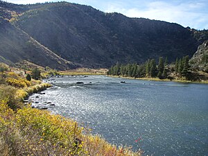
The Madison River is a headwater tributary of the Missouri River, approximately 183 miles (295 km) long, in the U.S. states of Wyoming and Montana. Its confluence with the Jefferson and Gallatin rivers near Three Forks, Montana form the Missouri River.
The Madison rises in Park County in northwestern Wyoming at the confluence of the Firehole and Gibbon rivers, a location known as Madison Junction in Yellowstone National Park. It flows west then north through the mountains of southwestern Montana to join the Jefferson and Gallatin rivers at Three Forks. The Missouri River Headwaters State Park is located on the Madison at Three Forks.[1] In its upper reaches in Gallatin County, Montana, the Hebgen Dam forms Hebgen Lake. In its middle reaches in Madison County, Montana, the Madison Dam forms Ennis Lake and provides hydroelectric power. In 1959, an earthquake formed Quake Lake just downstream from Hebgen Dam.
The river was named by Lewis and Clark in July 1805, for US Secretary of State James Madison.
Angling The Madison
The Madison River from Madison Junction in Yellowstone to Three Forks, Montana is a fly-fishing mecca for serious anglers.

See also
References
- Back, Howard (1938). The Waters of the Yellowstone with Rod and Fly. New York: Dodd & Mead.
{{cite book}}: Cite has empty unknown parameter:|coauthors=(help)
- Parks, Richard (1998). Fishing Yellowstone National Park. Helena, MT: Falcon Press. ISBN 1560446250.
- Brooks, Charles E. (1979). The Living River-A Fisherman's Intimate Profile of the Madison River Watershed--Its History, Ecology, Lore and Angling Opportunities. Garden City, NJ: Nick Lyons Books. ISBN 0385156553.
- Mathews, Craig (1997). The Yellowstone Fly-Fishing Guide-A authoritative guide to the waters of Yellowstone National Park. Guilford, CT: The Lyons Press. ISBN 155821545X.
{{cite book}}: Unknown parameter|coauthors=ignored (|author=suggested) (help)
- Brooks, Charles E. (1984). Fishing Yellowstone Waters. Clinton, NJ: New Win Publishing Inc. ISBN 0832903531.
- Holt, John (1996). Montana Fly-Fishing Guide-East. Guilford, CT: The Lyons Press. ISBN 1585745294.
{{cite book}}: Cite has empty unknown parameter:|coauthors=(help)
- Holt, John (1993). River Journal - Madison. Frank Amato Publications. ISBN 1878175270.
{{cite book}}: Text "Portland, OR" ignored (help)
